File:Map of Lydia ancient times-en.svg.png
Jump to navigation
Jump to search
No higher resolution available.
Map_of_Lydia_ancient_times-en.svg.png (400 × 277 pixels, file size: 28 KB, MIME type: image/png)
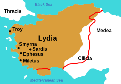
By Original: User:RokeSVG: User:NektoEnglish: User:WillemBK - Original picture:File:Map of Lydia ancient times.jpgInfo from these maps:Map 1 (brown):"middle of the 6th century at the time of King Croesus"http://i-cias.com/e.o/lydia.htmMap 2 (red line):"7th C. BCE roughly from 690 to 546 BCE"http://www.ancientanatolia.com/map07.htmSVG picture:File:Map of Lydia ancient times rus.svg, CC BY-SA 3.0, https://commons.wikimedia.org/w/index.php?curid=25815473
File history
Click on a date/time to view the file as it appeared at that time.
| Date/Time | Thumbnail | Dimensions | User | Comment | |
|---|---|---|---|---|---|
| current | 20:08, 9 August 2018 | | 400 × 277 (28 KB) | Lrburdak (talk | contribs) |
- You cannot overwrite this file.