Arabian Sea

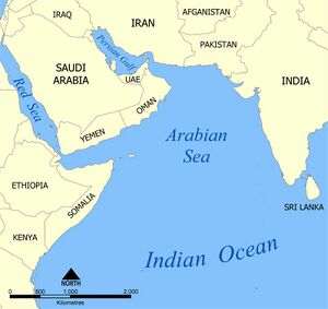
The Arabian Sea (अरब सागर) is a region of the northern Indian Ocean bounded on the east by India, on the north by Iran and on the west by northeastern Somalia and the Arabian Peninsula. Historically the sea has been known by other names including the Erythraean Sea and the Persian Sea. Its total area is 3,862,000 km2 (1,491,000 sq mi) and its maximum depth is 4,652 metres (15,262 ft). The Gulf of Aden is in the southwest, connecting the Arabian Sea to the Red Sea through the strait of Bab-el-Mandeb, and the Gulf of Oman is in the northwest, connecting it to the Persian Gulf.
The Arabian Sea has been crossed by important marine trade routes since the third or second millennium BCE. Major seaports include Jawaharlal Nehru Port in Mumbai, the Port of Karachi and the Gwadar Port in Pakistan and the Port of Salalah in Oman. Other important ports include in India, Kandla Port, and Mormugao in Goa.
संक्षिप्त जानकारी
अरब सागर जिसका भारतीय नाम सिंधु सागर है, भारतीय उपमहाद्वीप और अरब क्षेत्र के बीच स्थित हिंद महासागर का हिस्सा है। अरब सागर लगभग 38,62,000 कि.मी.2 सतही क्षेत्र घेरते हुए स्थित है तथा इसकी अधिकतम चौड़ाई लगभग 2,400 किमी (1,500 मील) है। सिन्धु नदी सबसे महत्वपूर्ण नदी है जो अरब सागर में गिरती है, इसके आलावा भारत की नर्मदा और ताप्ती नदियाँ अरब सागर में गिरती हैं। यह एक त्रिभुजाकार सागर है जो दक्षिण से उत्तर की ओर क्रमश: संकरा होता जाता है और फ़ारस की खाड़ी से जाकर मिलता है। अरब सागर के तट पर भारत के अलावा जो महत्वपूर्ण देश स्थित हैं उनमें ईरान, ओमान, पाकिस्तान, यमन और संयुक्त अरब अमीरात सबसे प्रमुख हैं।
इसका प्राचीन भारतीय नाम "सिन्धु सागर" इसमें गिरने वाली सिन्धु नदी के नाम पर पड़ा माना जाता है। उर्दू और फ़ारसी में इसे बह्र-अल्-अरब कहते हैं। यूनानी भूगोलवेत्ता और यात्री इसे इरीथ्रियन सागर के नाम से भी संबोधित करते थे।[1]
External links
Author
| Dayanand Deswal दयानन्द देसवाल |

