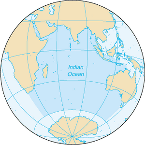
Indian Ocean
| Author:Laxman Burdak, IFS (R) |

Indian Ocean (हिन्द महासागर) is the third-largest of the world's oceanic divisions, covering 70,560,000 km2 (27,240,000 sq mi) or 19.8% of the water on the Earth's surface.[1]
Variants
- Indian Ocean (हिन्द महासागर)
- Mahodadhi महोदधि (AS, p.731)
- Ratnakara रत्नाकर (AS, p.776)
Location
It is bounded by Asia to the north, Africa to the west, and Australia to the east. To the south it is bounded by the Southern Ocean or Antarctica, depending on the definition in use.[2] Along its core, the Indian Ocean has some large marginal or regional seas such as the Arabian Sea, the Laccadive Sea, the Somali Sea, Bay of Bengal, and the Andaman Sea.
Rivers
The Indian Ocean drainage basin covers 21,100,000 km2 (8,100,000 sq mi), virtually identical to that of the Pacific Ocean and half that of the Atlantic basin, or 30% of its ocean surface (compared to 15% for the Pacific). The Indian Ocean drainage basin is divided into roughly 800 individual basins, half that of the Pacific, of which 50% are located in Asia, 30% in Africa, and 20% in Australasia. The rivers of the Indian Ocean are shorter in average (740 km) than those of the other major oceans. The largest rivers are (order 5) the Zambezi, Ganges-Brahmaputra, Indus, Jubba, and Murray rivers and (order 4) the Shatt al-Arab, Wadi Ad Dawasir (a dried-out river system on the Arabian Peninsula) and Limpopo rivers.[14]
हिन्द महासागर
हिन्द महासागर दुनिया का तीसरा सबसे बड़ा समुद्र है और पृथ्वी की सतह पर उपस्थित पानी का लगभग 20% भाग इसमें समाहित है। उत्तर में यह भारतीय उपमहाद्वीप से, पश्चिम में पूर्व अफ्रीका; पूर्व में हिन्दचीन, सुंदा द्वीप समूह और ऑस्ट्रेलिया, तथा दक्षिण में दक्षिणध्रुवीय महासागर से घिरा है। विश्व में केवल यही एक महासागर है जिसका नाम किसी देश के नाम यानी, हिन्दुस्तान (भारत) के नाम है। संस्कृत में इसे रत्नाकर यानि रत्न उत्पन्न करने वाला कहते हैं, जबकि प्राचीन हिन्दू ग्रंथों में इसे हिन्द महासागर कहा गया है।
रत्नाकर समुद्र
रत्नाकर (AS, p.776) : रत्नाकर भारत और लंका के बीच का समुद्र, जो प्राचीन काल से ही सुंदर रत्नों विशेषतः मोतियों के लिए प्रसिद्ध है। 'रघुवंश' 13,1 में महाकवि कालिदास ने भारत-लंका के मध्य स्थित समुद्र के लिए 'रत्नाकर' शब्द का प्रयोग किया है- 'रत्नाकरं वीक्ष्य मिथः स जायां रामाभिधानो हरिरित्युवाच।' कालीदास के 'रघुवंश' 13, 17 में इस समुद्र के तट पर सीपियों से भिन्न हुए मोतियों (पर्यस्तमूक्तापटल) का वर्णन है।[3]
महोदधि
महोदधि (AS, p.731):भारत के दक्षिण में स्थित समुद्र जिसे 'इंडियन ओशन' (Indian Ocean) कहा जाता है--'सेतुर्येन महोदधौ विरचित: क्वासौदशस्यांतक:' से स्पष्ट है कि राम ने इसी समुद्र पर पुल बांधकर लंका पर चढ़ाई की थी.[4]
प्रभास=प्रभासपाटन=प्रभासपट्टन
विजयेन्द्र कुमार माथुर[5] ने लेख किया है ...1. प्रभास (AS, p.584): प्रभास अथवा 'प्रभासपाटन' अथवा 'प्रभासपट्टन' काठियावाड़ के समुद्र तट पर स्थित बीराबल बंदरगाह की वर्तमान बस्ती का प्राचीन नाम है। यह एक प्रमुख तीर्थ स्थान है। किंवदंती के अनुसार जरा नामक व्याघ का बाण लगने से भगवान श्रीकृष्ण इसी स्थान पर परम धाम सिधारे थे। महाभारत के अनुसार यह सरस्वती-समुद्र संगम पर स्थित प्रसिद्ध तीर्थ था- 'समुद्रं पश्चिमं गत्वा सरस्वत्यब्धि संगमम्' महाभारत 35, 77.
यह विशिष्ट स्थल या देहोत्सर्ग तीर्थ नगर के पूर्व में हिरण्या, सरस्वती तथा कपिला के संगम पर बताया जाता है। इसे प्राची त्रिवेणी भी कहते हैं। युधिष्ठिर तथा अन्य पांडवों ने अपने वनवास काल में अन्य तीर्थों के साथ प्रभास की भी यात्रा की थी- 'द्विजै: पृथिव्यां प्रथितं महद्भिस्तीर्थ प्रभासं समुषजगाम' महाभारत, वनपर्व 118, 15. इस तीर्थ को महोदधि (समुद्र) का तीर्थ कहा गया है- 'प्रभासतीर्थ संप्राप्य पुण्यं तीर्थ महोदवे:-वनपर्व 19, 3.
External links
References
- ↑ Eakins, B.W.; Sharman, G.F. (2010). "Volumes of the World's Oceans from ETOPO1". Boulder, CO: NOAA National Geophysical Data Center.
- ↑ 'Indian Ocean' — Merriam-Webster Dictionary Online". Retrieved 7 July 2012. "ocean E of Africa, S of Asia, W of Australia, & N of Antarctica area ab 73,427,795 square kilometres (28,350,630 sq mi)"
- ↑ Aitihasik Sthanavali by Vijayendra Kumar Mathur, p. 776
- ↑ Aitihasik Sthanavali by Vijayendra Kumar Mathur, p.731
- ↑ Aitihasik Sthanavali by Vijayendra Kumar Mathur, p.584

