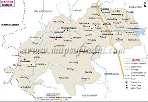
Andi Kanker
| Author:Laxman Burdak, IFS (R) |

Andi () is a village in Kanker tahsil of Kanker district in Chhattisgarh.
Variants
- Andali (mentioned in Kanker Copper Plates Of Pamparajadeva (Kalachuri) Samvat 965 And 966 = 12.08.1213 and 06.10.1214)
Jat Gotras Namesake
- Andi = Andi = Andali, a village in Kanker tahsil of Kanker district in Chhattisgarh, mentioned in Kanker Copper Plates Of Pamparajadeva (Kalachuri) Samvat 965 And 966 = 12.08.1213 and 06.10.1214
- Andi (Jat clan = Andi = Andali (आण्डलि) (L.10). Andali (आण्डलि) (L.10) is mentioned in Tahankapar Plate Of Pamparajadeva - (Kalachuri) Year 966 (=1214 AD). [1] Andali = Andi is a village in Kanker tahsil of Kanker district in Chhattisgarh.
Origin
Location
It is situated 30km away from Kanker. According to Census 2011 information the location code or village code of Andi village is 447799. Andi village is located in Kanker tehsil of Uttar Bastar Kanker district in Chhattisgarh, India. As per 2009 stats, Aandi is the gram panchayat of Andi village.The total geographical area of village is 571.11 hectares. [2]
History
No. 20.- Kanker Copper Plates Of Pamparajadeva (Kalachuri) Samvat 965 And 966 = 12.08.1213 and 06.10.1214 By Hira Lal, B.A., Nagpur.[3] mention the towns and villages Kakaira, Padi, Kogara, Andali, Jaipara, Chikhali and Vanikotta.
Andali is probably represented by the present Andni (Anjni), 10 miles east of [[Kanker.
Population
Andi has a total population of 1,291 peoples, out of which male population is 619 while female population is 672. Literacy rate of andi village is 69.56% out of which 80.61% males and 59.38% females are literate. There are about 287 houses in andi village. Pincode of andi village locality is 493558.[4]
References
- ↑ Corpus Inscriptionium Indicarium Vol IV Part 2 Inscriptions of the Kalachuri-Chedi Era, Vasudev Vishnu Mirashi, 1905, p.599-602
- ↑ https://villageinfo.in/chhattisgarh/uttar-bastar-kanker/kanker/andi.html
- ↑ Epigraphia Indica Vol. IX (1907-08): A S I, Edited by E. Hultzsoh, Ph.D. & Sten Konow, Ph.D., p.167
- ↑ https://villageinfo.in/chhattisgarh/uttar-bastar-kanker/kanker/andi.html

