Haveli
| Author:Laxman Burdak, IFS (R) |

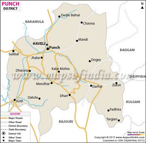
Haveli (हवेली) is a tahsil town in Poonch district in the union territory of Jammu and Kashmir, India. It is headquartered at the Poonch Town.
Variants
Location
Jat Gotras
History
The History of Poonch District of the princely state of Jammu and Kashmir had four tehsils: Haveli and Mendhar in the east, and Bagh and Sudhanoti in the west.[1]
As a result of the First Kashmir War of 1947, the Haveli tehsil got bifurcated, with the northern half passing into Pakistani control and the southern half remaining in Indian-administered Kashmir. The Pakistani half of the tehsil has now been made into a district.
The Haveli tehsil of the Indian-administered Kashmir was further bifurcated into the present Haveli tehsil and the Mandi tehsil based at Mandi.
Villages in Haveli tahsil
Town: 1 Punch,
Villages 1 Ajot, 2 Aslam Abad, 3 Bachian Wali, 4 Bandi Checkiyan, 5 Banpat, 6 Bhenchh, 7 Chaktroo, 8 Chandak, 9 Dalan, 10 Danadoyian, 11 Dara Dullian, 12 Darah Bagyal, 13 Degwar Maldayalan, 14 Degwar Tarwan, 15 Dharam Sal Khari, 16 Dhokri, 17 Dingla, 18 Forest Block Haveli, 19 Gulpur, 20 Hari Budha , 21 Janyar, 22 Jhulas, 23 Kalai, 24 Kankote , 25 Kanuian, 26 Karmara, 27 Khanetar, 28 Kirni, 29 Kolian, 30 Kosalian, 31 Maidan, 32 Mandhar, 33 Mangnar, 34 Nabana, 35 Nakarkote , 36 Nangli, 37 Naraian , 38 Nona Bandi , 39 Noorkote, 40 Polas, 41 Qasbah, 42 Salotri, 43 Saral, 44 Seri Chowan, 45 Serian, 46 Serikhawaja, 47 Shahpur, 48 Shindhra, 49 Timira,
Source - https://www.census2011.co.in/data/subdistrict/16-haveli-punch-jammu-and-kashmir.html
Tourism
External links
References
- ↑ Snedden, Christopher (2015), Understanding Kashmir and Kashmiris, Oxford University Press, Appendix V, ISBN 978-1-84904-342-7

