Kunlun Mountains
| Author:Laxman Burdak, IFS (R) |


Kunlun Mountains (कुनलुन पर्वत) are one of the longest mountain chains in Asia, extending more than 3,000 kilometres.
Variants
Location
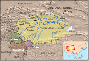
In the broadest sense, it forms the northern edge of the Tibetan Plateau south of the Tarim Basin and the Gansu Corridor and continues east south of the Wei River to end at the North China Plain.
Extent
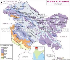
From the Pamirs of Tajikistan, it runs east along the border between Xinjiang and Tibet autonomous regions to the Sino-Tibetan ranges in Qinghai province.[1] It stretches along the southern edge of what is now called the Tarim Basin, the infamous Takla Makan or "sand-buried houses" desert, and the Gobi Desert. A number of important rivers flow from it including the Karakash River ('Black Jade River') and the Yurungkash River ('White Jade River'), which flow through the Khotan Oasis into the Taklamakan Desert.
Altyn-Tagh or Altun Range is one of the chief northern ranges of the Kunlun. Its eastern extension Qilian Shan is another main northern range of the Kunlun. In the south main extension is the Min Shan. Bayan Har Mountains, a southern branch of the Kunlun Mountains, forms the watershed between the catchment basins of China's two longest rivers, the Yangtze River and the Huang He.
The highest mountain of the Kunlun Shan is the Kunlun Goddess (7,167 m) in the Keriya area. The Arka Tagh (Arch Mountain) is in the center of the Kunlun Shan; its highest point is Ulugh Muztagh (6,973 m). Some authorities claim that the Kunlun extends northwest-wards as far as Kongur Tagh (7,649 m) and the famous Muztagh Ata (7,546 m). But these mountains are physically much more closely linked to the Pamir group (ancient Mount Imeon).
The mountain range formed at the northern edges of the Cimmerian Plate during its collision, in the Late Triassic, with Siberia, which resulted in the closing of the Paleo-Tethys Ocean.
The range has very few roads and in its 3,000 km length is crossed by only two. In the west, Highway 219 traverses the range en route from Yecheng, Xinjiang to Lhatse, Tibet. Further east, Highway 109 crosses between Lhasa and Golmud.
In popular culture
The Kunlun mountains (spelled "Kuen-Lun" in the book) are described as the location of the Shangri-La monastery in the 1933 novel Lost Horizon by English writer James Hilton.
The mountains are the site of the fictional city of K'un Lun in the Marvel Comics Iron Fist series and the TV show of the same name.[2]
कुनलुन पर्वत
कुनलुन पर्वत शृंखला (चीनी: 昆仑山, कुनलुन शान; मंगोलियाई: Хөндлөн Уулс, ख़ोन्दलोन ऊल्स) मध्य एशिया में स्थित एक पर्वत शृंखला है। 30000 किलोमीटर से अधिक चलने वाली यह शृंखला एशिया की सब से लम्बी पर्वतमालाओं में से एक गिनी जाती है। कुनलुन पर्वत तिब्बत के पठार के उत्तर में स्थित हैं और उसके और तारिम द्रोणी के बीच एक दीवार बनकर खड़े हैं। पूर्व में यह उत्तर चीन के मैदानों में वेई नदी के दक्षिण-पूर्व में जाकर ख़त्म हो जाते हैं। कुनलुन पर्वत भारत के अक्साई चिन इलाक़े को भी तारिम द्रोणी से अलग करते हैं, हालांकि वर्तमान में अक्साई चिन क्षेत्र चीन के क़ब्ज़े में है। इस पर्वतमाला में कुछ ज्वालामुखी भी स्थित हैं।[3]
भूगोल: कुनलुन पर्वत ताजिकिस्तान की पामीर पर्वतमाला से शुरू होकर पूर्व को चलते हैं, जहाँ यह चीन द्वारा नियंत्रित तिब्बत और शिञियांग के क्षेत्रों की सीमा के साथ-साथ चलकर पूर्व में चिंग हई प्रांत में अंत होते हैं। यह तारिम द्रोणी, टकलामकान रेगिस्तान और गोबी रेगिस्तान की दक्षिणी सीमा भी बनाते हैं। कुनलुन पहाड़ों से कुछ महत्वपूर्ण नदियाँ शुरू होती हैं, जैसे कि काराकाश नदी और युरुंगकाश नदी, जो ख़ोतान के मरुद्यान (ओएसिस) से होकर टकलामकान रेगिस्तान की रेतों में ग़ायब हो जाती हैं।
कुनलुन शृंखला की सब से ऊँची छोटी ७,१६७ मीटर ऊँचा कुनलुन देवी (Kunlun Goddess, कुनलुन गॉडॅस) पर्वत है। पश्चिम की ओर दो इस से भी ऊँचे पहाड़ हैं - कोन्गुर ताग़ (7649 मीटर) और मुज़ताग़ अता (7546 मीटर) - हालांकि बहुत से भूवैज्ञानिक इन्हें कुनलुन की बजाए पामीर पर्वतों का हिस्सा मानते हैं।
कुनलुन पर्वतों से बहुत ही कम सड़कें निकलती हैं - एक तो राजमार्ग 219 है जो शिञियांग के येचेंग शहर से तिब्बत के ल्हात्से शहर तक जाता है। उस से पूर्व में राजमार्ग 109 है जो तिब्बत की राजधानी ल्हासा से चिंग हई प्रांत के गोलमुद शहर तक जाता है।
External links
References
- ↑ "Kunlun Mountains". Encyclopædia Britannica
- ↑ Young, Sage (March 16, 2017). "What Is K'un-Lun In 'Iron Fist'? The "Lost City" Has A Mystical History". www.bustle.com. Bustle Digital Group.
- ↑ Huadong Guo. "Radar remote sensing applications in China". CRC Press, 2001. ISBN 9780415256766. "... A group of volcanoes northeast of Aksayqin Lake in the western Kunlun Mountains have been identified on SIR-C/X-SAR imagery acquired on April 17, 1994. The volcanoes are at an elevation over 5300m ..."

