Manda Jammu
| Author:Laxman Burdak, IFS (R) |


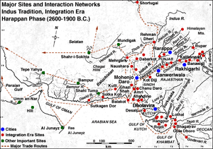
Manda is a village near Akhnoor in Jammu district of Jammu and Kashmir, India. It is considered to be the most northern site belonging to the Indus Valley Civilisation.
Location
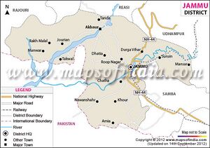
Manda is situated near Akhnoor on the right bank of Chenab River in the foot hills of Pir Panjal range, 28 km northwest of Jammu. Coordinates: 32°56′00″N 74°48′00″E
History
For History see Akhnoor
Excavation
It was excavated by Archaeological Survey of India during 1976-77 by J. P. Joshi.[1] Excavation at Manda revealed a 9.20 m deposit with threefold sequence with two sub periods in Period I. Period II has early historical pottery of types comparable with those of same period from Northern part of India and period III is represented by Kushan antiquaries and house walls with 3 m wide street.[2] After the Kushan period, the site seems to have been deserted.[3]
Historical significance
Manda is situated on the right bank of Chenab River in the foot hills of Pir Panjal range, 28 km northwest of Jammu, and considered as northern most limit of Indus Valley or Harappan Civilisation.[4]
It is considered as a site established to procure wood from Himalayan Sub hills and send downriver to other towns of Indus Valley Civilisation.[5] As this site is situated at Himalayan foot hills, it gets significance by establishing northern most limit of geological boundary of Indus Valley Civilisation.
See also
External links
References
- ↑ Indian Archaeology 1976-77, A Review. Archeologival Survey of India, New Delhi.1980. Page 19-21. ASI
- ↑ Archaeological Survey of India
- ↑ Indian Archaeology 1976-77, A Review. Archeologival Survey of India, New Delhi.1980. Page 19-21.
- ↑ Archaeological Survey of India
- ↑ McIntosh, Jane.(2008) The Ancient Indus Valley, New Perspectives. ABC-CLIO.Page 209,412
Back to Indus Valley Civilization/ Ancient Villages in Jammu and Kashmir

