Mandi Poonch
| Author:Laxman Burdak, IFS (R) |

Mandi (मंडी) is a tahsil town in Poonch district in the union territory of Jammu and Kashmir, India.
Variants
Location
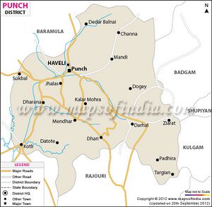
The town is located 20 km from the district headquarters Poonch. Mandi is about 171 km from Srinagar and 1 km south of the Line of Control with Pakistan. The Ancient Hindu temple Baba Budha Amernath is located here.
Jat Gotras
History
Mandi - It is a small village in a narrow valley enclosed by steep and grassy hills of no great elevation, situated near the confluence of two streams namely Gagri and Pulsta. Mandir Swami Budha Amar Nath Ji is situated in this village. Mandi is about 20 kms. from Poonch town. Due to cool climate and proximity to the poonch town, Mandi has become a favourable place for tourists to visit, in summer.[1]
Villages in Mandi tahsil
1 Arai, 2 Atoli, 3 Azamabad, 4 Baila, 5 Bandikama Khan, 6 Brachhar, 7 Chak Rara, 8 Chhambar Kanaria, 9 Chikri Ban, 10 Chilla, 11 Dana Dhakran, 12 Danugam, 13 Dedar Balnai, 14 Dhangri, 15 Dhara, 16 Fatehpur, 17 Gagrian, 18 Gali, 19 Gali Nag, 20 Jalian, 21 Jandrola, 22 Kalani, 23 Kehnu, 24 Lohelbelah, 25 Loran, 26 Mandi, 27 Markote, 28 Marnote, 29 Pindi, 30 Plera, 31 Raj Pur, 32 Salunian, 33 Sathra, 34 Sawajian, 35 Seikhlu , 36 Seroi, 37 Trichal,
Source - https://www.census2011.co.in/data/subdistrict/17-mandi-punch-jammu-and-kashmir.html

