
Mexico
| Author: Dayanand Deswal दयानन्द देसवाल |

Mexico (Spanish: México), (हिन्दी उच्चारण - मेहिको ), officially the United Mexican States (Spanish: Estados Unidos Mexicanos), is a federal republic in the southern half of North American continent. It is bordered to the north by the United States; to the south and west by the Pacific Ocean; to the southeast by Guatemala, Belize, and the Caribbean Sea; and to the east, by the Gulf of Mexico.
Covering almost two million square kilometers (over 760,000 sq mi), Mexico is the sixth largest country in the Americas by total area and the 13th largest independent nation in the world. With an estimated population of over 120 million, it is the eleventh most populous country and the most populous Spanish-speaking country in the world while being the second most populous country in Latin America.
Short History
Before 1521, when the Spanish Empire conquered and colonized the territory, Mexico was home to many advanced Mesoamerican civilizations, such as the Olmec, Toltec, Teotihuacan, Zapotec, Maya and Aztec. Three centuries later, this territory became Mexico, following recognition in 1821 after the colony's Mexican War of Independence. The Mexican–American War (1846–48) led to the territorial cession of the extensive northern borderlands, one-third of its territory, to the United States. The Pastry War, the Franco-Mexican War, a civil war, two empires and a domestic dictatorship occurred through the 19th century. The dictatorship was overthrown in the Mexican Revolution of 1910, which culminated with the promulgation of the 1917 Constitution and the emergence of the country's current political system.
Fact-sheet on Mexico
Official Name: United Mexican States (Estados Unidos Mexicanos)
Area: 1,964,375 sq km (World’s 14th largest)
Location: South of USA (common border 3,153 km), North of Guatemala (956 km) & Belize (193 km); between Pacific Ocean, and Gulf of Mexico (and Atlantic Ocean)
Population: 123.8 million (December 2014 estimate) (World’s 12th largest)
Administrative Divisions: 31 States (Provincias) and 1 Federal District (Distrito Federal)
Capital: Mexico City (Ciudad de México / México D.F.); Population: 23 million (DF proper: 9 Million, Rest of Metropolitan area: 14 Million)
Other Main Cities: Guadalajara, Monterrey, León, Tijuana, Cancún, Acapulco, Puebla
Climate: Mexico has a most diverse climate. Mexico City has a pleasant ‘subtropical highland climate with a moderate winter and comfortably cool rest of the year.
Currency: (Mexican) Peso or MXN; freely convertible;1 US$=MXN 15.25 (31.03.2015)
Time Zone: Mexico City, and most of the country, UTC (-) 6 hrs, with clocks advanced by 1 hour between April-October as Daylight Saving Time.
Languages: Spanish (92.7%); 66 other indigenous languages; English very limited use.
Religions: Vast majority Roman Catholic; rest follow indigenous beliefs or are agnostics.
Life expectancy: Overall: 75.43; Male: 72.67; Female: 78.32 (2014 est. CIA World book)
Literacy: 94% (Males: 94.8%, Females: 92.3%) (2014 figures)[1]
Mexico's cultural similarity with India
लेखक - स्वामी ओमानन्द सरस्वती
(विस्तार से यहां पढिये - Haryana Ke Vir Youdheya/तृतीय अध्याय (पृष्ठ 103-105)
अमेरिका में परम्परागत जनश्रुति -
प्राचीन मैक्सिकन या एजटेक लोगों में यह अनुश्रुति विद्यमान थी कि उनकी सभ्यता का मूल पश्चिम या उत्तर-पश्चिम में है । सम्पूर्ण अमेरिका महाद्वीप में निवास करने वाली जातियों में यह अनुश्रुति किसी न किसी रूप में विद्यमान थी । एजटेक लोगों में तो यह लिखित रूप में पाई जाती है । यहां ध्यान रखना चाहिये कि अमेरिकन लोगों के लिये पश्चिम या उत्तर-पश्चिम एशियाटिक देश वा प्राच्य देश ही होंगे । अमेरिकन अनुश्रुति के अनुसार क्वेटसालकटल नाम का एक शुभ्र व्यक्ति प्राच्य देशों से उनके देश में आया था । इसकी दाढ़ी बहुत लम्बी थी, कद उंचा, बाल काले और रंग शुभ्र था । इसने अमेरिका निवासियों को कृषि की शिक्षा दी, धातुओं का प्रयोग सिखलाया और शासन व्यवस्था की कला में निपुणता प्राप्त कराई ।
क्वेटसालकटल अमेरिकन लोगों के लिये इतना अधिक लाभकारक और उपयोगी सिद्ध हुआ कि पीछे से उसकी देवता की तरह पूजा होने लगी । इस रहस्यमय व्यक्ति ने अमेरिका में सतयुग का प्रारम्भ किया । इसके प्रभाव से पृथ्वी पुष्पों और फलों से परिपूर्ण हो गई । इतना बड़ा अनाज होने लगा कि एक व्यक्ति एक सिट्टे से अधिक न उठा सकता था । नानाविध रंगों की कपास उगने लगी । अभिप्राय यह है कि उस दैवी पुरुष के प्रभाव से अमेरिका में नवीन युग प्रारम्भ हो गया ।
परन्तु यह क्वेटसालकटल बहुत समय तक अमेरिका में न रह सका । किसी देवता के प्रकोप से - क्या कारण था, इसका हमें पता नहीं है, इसे देश छोड़कर जाना पड़ा । जब वह मैक्सिकन खाड़ी के समीप पहुँच गया, तब उसने अपने अनुयायियों से विदा ली और समुद्र पार करके वापिस चला गया ।
यह क्वेटसालकटल कौन था ? इसमें सन्देह नहीं कि यह प्राच्य देश का रहने वाला था और इसका वर्णन सूचित करता है कि यह आर्य जाति का था । हम केवल अनुमान नहीं कर रहे हैं । हमारे पास इसके लिये दृढ़प्रमाण विद्यमान हैं । यह क्वेटसालकटल कौन था, इसे स्पष्ट करने के लिए रामायण के उत्तरकाण्ड में एक बड़ी मनोरंजक और उपयोगी कथा मिलती है । उसमें राक्षसों की उत्पत्ति की कथा लिखते हुये सालकटंकट वंश के राक्षसों की उत्पत्ति का वर्णन किया है । इनका विनाश विष्णु ने किया और उससे पराजित होकर सालकटंकट वंश के राक्षस लोग, जिनका मूल निवास-स्थान लंकाद्वीप था, पाताल देश में चले गये । इनका नेता “सुमाली” था ।
इस प्रकार यह स्पष्ट सिद्ध है कि विष्णु द्वारा पराजित सालकटंकट राक्षस पाताल वा अमेरिका देश में जा बसे थे और उन्हीं में से सुमाली, जो उनका नेता था, उसकी कन्या कैकसी के साथ देवर्षि विश्रवा का विवाह हुआ । आदि सृष्टि से ही पातालादि देशों के साथ हमारे पूर्वजों का विवाहादि सम्बन्ध प्रचलित था क्योंकि हमारा महाभारत पर्यन्त सारे संसार में चक्रवर्ती राज्य रहा ।
अमेरिका के “मैक्सिकन” क्वेटसालकटल और भारतीय सालकटंकट ये दोनों ही एक शब्द के रूपान्तर हैं । इन दोनों शब्दों का जनश्रुति एवं रामायण के वर्णन की इतिहास में पूर्ण समानता है । मैक्सिकन इतिवृत्त के अनुसार जो क्वेटसालकटल प्राच्य देशों का देवता उस देश के निवासियों को कृषि, धातुविद्या तथा शासन व्यवस्था सिखाने में समर्थ हुआ था, वह सालकटंकट सुमाली के अतिरिक्त अन्य कोई नहीं था ।
Also see
Teotihuacan - the famous place near Mexico City where great pyramids of Aztec civilisation are located.
Note by Author of this page
I have lived in Mexico City from 2000 to 2004 on official assignment. The two photos of Teotihuacan archaeological site in the photo gallery below, were snapped by me in 2002, by an ordinary photo camera. - User:Dndeswal
Photo Gallery
-

Pyramids at Teotihucan - photo snapped by Dayanand Deswal in 2002 AD
-
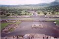
Overview of Teotihuacan - photo snapped by Dayanand Deswal in 2002 AD


External Links
References
Back to Places