Nandaprayag
| Author:Laxman Burdak, IFS (R) |


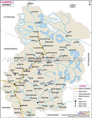
Nandaprayag (नंदप्रयाग) is a town in Chamoli district in the Indian state of Uttarakhand. Nandaprayag is one of the Panch Prayag (five confluences) of Alaknanda River, and lies at the confluence of Alaknanda River and Nandakini River.[1]
Location
Nandaprayag is located at 30.33°N 79.33°E. It has an average elevation of 1,358 metres (4,455 feet). The 538 km long NH 58, connecting NCR with the holy shrine Badrinath and the Mana pass near Indo-Tibet border, pass through this quaint town. The town is nestled in the mountainous terrain overlooking the confluence or holy "prayag".
Variants
- Nandaprayaga (नंदप्रयाग) (जिला चमोली, उ.प्र.) (AS, p.470)
History
Nandaprayag was once the capital of Yadu kingdom.
नंदप्रयाग
विजयेन्द्र कुमार माथुर[2] ने लेख किया है ...नंदप्रयाग (AS, p.470) गढ़वाल, उत्तराखंड का एक प्राचीन तीर्थ स्थान है। नंदाकिनी नदी, नंदा देवी पर्वत से निकल कर नंदप्रयाग में ही आकर अलकनंदा में मिल जाती है। जनश्रुति है कि प्राचीन काल में कण्व ऋषि का आश्रम तथा शकुंतला का जन्म स्थान नंदप्रयाग में ही था। अलकनंदा और नंदाकिनी नदियों के संगम स्थल के लिए भी नंदप्रयाग प्रसिद्ध है, जिससे इसका नाम नंदप्रयाग हुआ है। (टि.गढ़वाल में संगम स्थानों का नाम प्राय: प्रयाग पर है, जैसे- देवप्रयाग, कर्णप्रयाग, रुद्रप्रयाग आदि।)
External links
References
- ↑ Uttaranchal. Rupa & Co. 2006. ISBN 81-291-0861-5. Page 12
- ↑ Aitihasik Sthanavali by Vijayendra Kumar Mathur, p.470

