Arctic Ocean
| Author: Laxman Burdak, IFS (R). |

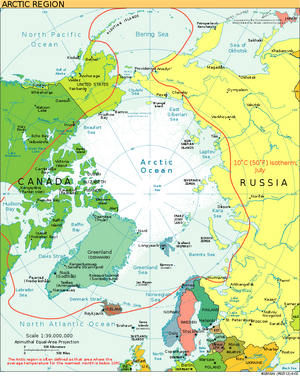
Arctic Ocean is the smallest and shallowest of the world's five major oceans, centring approximately on the North Pole. It has been described approximately as an estuary of the Atlantic Ocean.[1][2] It is also seen as the northernmost part of the all-encompassing World Ocean.
Variants
Location
The Arctic Ocean includes the North Pole region in the middle of the Northern Hemisphere and extends south to about 60°N. The Arctic Ocean is surrounded by Eurasia and North America, and the borders follow topographic features: the Bering Strait on the Pacific side and the Greenland Scotland Ridge on the Atlantic side. It is mostly covered by sea ice throughout the year and almost completely in winter. The Arctic Ocean's surface temperature and salinity vary seasonally as the ice cover melts and freezes; its salinity is the lowest on average of the five major oceans, due to low evaporation, heavy fresh water inflow from rivers and streams, and limited connection and outflow to surrounding oceanic waters with higher salinities.
History
North America
Human habitation in the North American polar region goes back at least 17,000–50,000 years, during the Wisconsin glaciation. At this time, falling sea levels allowed people to move across the Bering land bridge that joined Siberia to northwestern North America (Alaska), leading to the Settlement of the Americas.[3]
Early Paleo-Eskimo groups included the Pre-Dorset (c. 3200–850 BC); the Saqqaq culture of Greenland (2500–800 BC); the Independence I and Independence II cultures of northeastern Canada and Greenland (c. 2400–1800 BC and c. 800–1 BC); and the Groswater of Labrador and Nunavik. The Dorset culture spread across Arctic North America between 500 BC and AD 1500. The Dorset were the last major Paleo-Eskimo culture in the Arctic before the migration east from present-day Alaska of the Thule, the ancestors of the modern Inuit.[4]
The Thule Tradition lasted from about 200 BC to AD 1600, arising around the Bering Strait and later encompassing almost the entire Arctic region of North America. The Thule people were the ancestors of the Inuit, who now live in Alaska, Northwest Territories, Nunavut, northern Quebec, Labrador and Greenland.[5]
Europe
For much of European history, the north polar regions remained largely unexplored and their geography conjectural. Pytheas of Massilia recorded an account of a journey northward in 325 BC, to a land he called "Eschate Thule", where the Sun only set for three hours each day and the water was replaced by a congealed substance "on which one can neither walk nor sail". He was probably describing loose sea ice known today as "growlers" or "bergy bits"; his "Thule" was probably Norway, though the Faroe Islands or Shetland have also been suggested.[6]
Early cartographers were unsure whether to draw the region around the North Pole as land (as in Johannes Ruysch's map of 1507, or Gerardus Mercator's map of 1595) or water (as with Martin Waldseemüller's world map of 1507). The fervent desire of European merchants for a northern passage, the Northern Sea Route or the Northwest Passage, to "Cathay" (China) caused water to win out, and by 1723 mapmakers such as Johann Homann featured an extensive "Oceanus Septentrionalis" at the northern edge of their charts.
The few expeditions to penetrate much beyond the Arctic Circle in that era added only small islands, such as Novaya Zemlya (11th century) and Spitzbergen (1596), though, since these were often surrounded by pack-ice, their northern limits were not so clear. The makers of navigational charts, more conservative than some of the more fanciful cartographers, tended to leave the region blank, with only fragments of known coastline sketched in.
उत्तरध्रुवीय महासागर
पृथ्वी के उत्तरी गोलार्ध में स्थित उत्तरीध्रुवीय महासागर या आर्कटिक महासागर, जिसका विस्तार अधिकतर आर्कटिक उत्तर ध्रुवीय क्षेत्र में है। विश्व के पांच प्रमुख समुद्री प्रभागों (पांच महासागरों) में से यह सबसे छोटा और उथला महासागर है। अंतरराष्ट्रीय जल सर्वेक्षण संगठन (upc) इसको एक महासागर स्वीकार करता है जबकि, कुछ महासागरविज्ञानी इसे आर्कटिक भूमध्य सागर या केवल आर्कटिक सागर कहते हैं और इसे अन्ध महासागर के भूमध्य सागरों में से एक मानते हैं।
लगभग पूरी तरह से यूरेशिया और उत्तरी अमेरिका से घिरा, आर्कटिक महासागर आंशिक रूप से साल भर में समुद्री बर्फ के ढका रहता है (और सर्दियों में लगभग पूर्ण रूप से). आर्कटिक महासागर का तापमान और लवणता, मौसम के अनुसार बदलती रहती है क्योंकि इसकी बर्फ पिघलती और जमती रहती है। पांच प्रमुख महासागरों में से इसकी औसत लवणता सबसे कम है, जिसका कारण कम वाष्पीकरण, नदियों और धाराओं से भारी मात्रा में आने वाला मीठा पानी और उच्च लवणता वाले महासागरों से सीमित जुड़ाव जिसके कारण यहां का पानी बहुत कम मात्रा में इन उच्च लवणता वाले महासागरों बह कर जाता है। ग्रीष्म काल में यहां की लगभग 50% बर्फ पिघल जाती है। राष्ट्रीय हिम और बर्फ आँकड़ा केन्द्र, उपग्रह आँकड़ों का प्रयोग कर आर्कटिक समुद्री बर्फ आवरण और इसके पिघलने की दर के पिछले सालों के आंकड़ों के आधार पर एक तुलनात्मक दैनिक रिकॉर्ड प्रदान करता है।
References
- ↑ Tomczak, Matthias; Godfrey, J. Stuart (2003). Regional Oceanography: an Introduction (2nd ed.). Delhi: Daya Publishing House. ISBN 978-81-7035-306-5. Archived from the original on 30 June 2007.
- ↑ [1]
- ↑ Goebel T, Waters MR, O'Rourke DH (2008). "The Late Pleistocene Dispersal of Modern Humans in the Americas" (PDF). Science. 319 (5869): 1497–502.
- ↑ "The Prehistory of Greenland" Archived 16 May 2008 at the Wayback Machine, Greenland Research Centre, National Museum of Denmark, accessed 14 April 2010.
- ↑ Park, Robert W. "Thule Tradition". Arctic Archaeology. Department of Anthropology, University of Waterloo.
- ↑ Pytheas Archived 18 September 2008 at the Wayback Machine Andre Engels.

