Berenice
| Author:Laxman Burdak, IFS (R) |

Berenice was an ancient city mentioned by Pliny.
Variants
- Arabic: برنيس, Barnīs
- Ancient Greek: Βερενίκη, Bereníkē
Origin
Berenice (Ancient Greek: Βερενίκη, Bereníkē) is the Ancient Macedonian form of the Attic Greek name Φερενίκη Pherenikē, which means "bearer of victory" from Ancient Greek φέρω (pherō) 'to bear', and νίκη (nikē) 'victory'.[1]
Jat Gotras Namesake
- Bera = Berenice (Pliny.vi.26, Pliny.vi.32, Pliny.vi.33)
- Beriya = Berenice (Pliny.vi.26, Pliny.vi.32, Pliny.vi.33)
History
Mention by Pliny
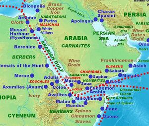
Pliny[2] writes.... Two miles distant from Alexandria is the town of Juliopolis.24 The distance thence to Coptos, up the Nile, is three hundred and eight miles; the voyage is performed, when the Etesian winds are blowing, in twelve days. From Coptos the journey is made with the aid of camels, stations being arranged at intervals for the supply of fresh water. The first of these stations is called Hydreuma25 and is distant26 twenty-two miles; the second is situate on a mountain, at a distance of one day's journey from the last; the third is at a second Hydreuma, distant from Coptos ninety-five miles; the fourth is on a mountain; the next to that is at another Hydreuma, that of Apollo, and is distant from Coptos one hundred and eighty-four miles; after which, there is another on a mountain. There is then another station at a place called the New Hydreuma, distant from Coptos two hundred and thirty miles: and next to it there is another, called the Old Hydreuma, or the Troglodytic, where a detachment is always on guard, with a caravansary that affords lodging for two thousand persons. This last is distant from the New Hydreuma seven miles. After leaving it we come to the city of Berenice27, situate upon a harbour of the Red Sea, and distant from Coptos two hundred and fifty-seven miles. The greater part of this distance is generally travelled by night, on account of the extreme heat, the day being spent at the stations; in consequence of which it takes twelve days to perform the whole journey from Coptos to Berenice.
24 Pliny is the only writer that mentions this place among the towns of Lower Egypt. Some suppose it to have been Nicopolis, or the City of Victory, founded by Augustus B.C. 29, partly to commemorate the reduction of Egypt to a Roman province, and partly to punish the Alexandrians for their adhesion to the cause of Antony and Cleopatra. Mannert, however, looks upon it as having been merely that suburb of Alexandria which Strabo (B. xvii.) calls Eleusis.
25 From the Greek ὕδρευμα, a "watering-place."
26 From Coptos, the modern Kouft or Keft. Ptolemy Philadelphus, when he constructed the port of Berenice, erected several caravansaries or watering-places between the new city and Coptos. Coptos was greatly enriched by the commerce between Lybia and Egypt on the one hand, and Arabia and India on the other.
27 Belzoni found traces of several of the stations here mentioned. The site of Berenice, as ascertained by Moresby and Carless, 1830–3, was nearly at the bottom of the inlet known as the Sinus Immundus, or Foul Bay. Its ruins still exist.
Mention by Pliny
Pliny[3] mentions 'The Gulfs Of The Red Sea'....The localities of this region are as follow: Berenice also, is here situate, so called after the name of the mother of Philadelphus, and to which there is a road from Coptos, as we have previously stated;10 then the Arabian Autei, and the Zebadei.
10 In c. 26 of the present Book.
Mention by Pliny
Pliny[4] mentions Troglodytice....Beyond this are forests, in which is Ptolemais8, built by Philadelphus for the chase of the elephant, and thence called Epitheras9, situate near Lake Monoleus. This is the same region that has been already mentioned by us in the Second Book,10 and in which, during forty-five days before the summer solstice and for as many after, there is no shadow at the sixth hour, and during the other hours of the day it falls to the south; while at other times it falls to the north; whereas at the Berenice of which we first11 made mention, on the day of the summer solstice the shadow totally disappears at the sixth hour, but no other unusual phænomenon is observed. That place is situate at a distance of six hundred and two miles from Ptolemais, which has thus become the subject of a remarkable theory, and has promoted the exercise of a spirit of the most profound investigation; for it was at this spot that the extent of the earth was first ascertained, it being the fact that Erastosthenes, beginning at this place by the accurate calculation of the length of the shadow, was enabled to determine with exactness the dimensions of the earth.
8 Called Theron, as well as Epitheras. It was an emporium on the coast of the Red Sea for the trade with India and Arabia. It was chiefly remarkable for its position in mathematical geography, as, the sun having been observed to be directly over it forty-five days before and after the summer solstice, the place was taken as one of the points for determining the length of a degree of a great circle on the earth's surface.
9 From the Greek ἐπὶ θήρας, "for hunting."
10 In B. ii. c. 75.
11 In the same Chapter.
Sinus Immundus or Foul Bay
Foul Bay (Greek: Akathartos Kolpos, "uncleaned bay"; Latin: Sinus Immundus) is a bay on the Egyptian side of the Red Sea, in the Red Sea Governorate. Foul Bay is located slightly north of the Tropic of Cancer. The town which lies at the most inland section of the bay is Berenice (Arabic: برنيس, Barnīs). The northern part of Foul Bay is a peninsula called Ras Banas. The ancient ruins of Berenice Troglodytica are located on the bay.

