Bihat State
| Author:Laxman Burdak, IFS (R) |

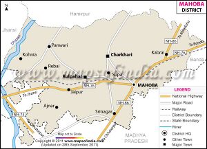
Bihat (बीहट) was a princely state in India during the British Raj, controlled by the Bundelkhand Agency.[1] Bihat is a small Village in Panwari Block in Mahoba District of Uttar Pradesh State, India.
Origin
Variants
- Bihat State (बीहट), बुंदेलखंड, (AS, p.639)
Location
Bihat is a small Village in Panwari Block in Mahoba District of Uttar Pradesh State, India. It belongs to Chitrakoot Division . It is located 63 KM towards west from District head quarters Mahoba. 12 KM from Panwari. 262 KM from State capital Lucknow. Bihat Pin code is 210429 and postal head office is Panwari.[2]
History
Raos of Bihat State: The rulers of Bihat State were called Raos.[3]
- Diwan Aparbal Singh, before 1807-1807
- Rao Bankat Rao, 1807-1828
- Rao Kamod Singh, 1828-1846
- Hardi Sah 1846-1859
- Govind Das 1859-1872
- Rao Mahum Singh 1872-after 1892
बीहट (बुंदेलखंड)
विजयेन्द्र कुमार माथुर[4] ने लेख किया है ...बीहट (AS, p.639) बुंदेलखंड में यमुना नदी के पश्चिम में 60 मील दूर स्थित है. इस स्थान पर यौधेय गणराज्य के [p.640]: सिक्के मिले हैं जो इस स्थान की प्राचीनता के सूचक हैं।
External links
References
- ↑ Imperial Gazetteer of India: Provincial Series, Volume 12. Superintendent of Government Print. 1908. p. 397.
- ↑ http://www.onefivenine.com/india/villages/Mahoba/Panwari/Bihat
- ↑ India Foreign and Political Department (1892). A Collection of Treaties, Engagements, and Sunnuds, Relating to India and Neighbouring Countries: Central India Agency, pt. 1-2. G.A. Savielle and P.M. Cranenburgh, Bengal Print. Company. p. 38-39.
- ↑ Aitihasik Sthanavali by Vijayendra Kumar Mathur, p.639-640

