Birbhum


Birbhum is the northernmost district of Burdwan division—one of the three administrative divisions of West Bengal. The district headquarters is located at Suri.[1]
Etymology
- Bir in Santali language means forests, and therefore, Birbhum could also mean a land of forests.[6][7]
Jat clans
Location
Situated between 23° 32' 30" (right above the tropic of cancer) and 24° 35' 0" north latitude and 87° 5' 25" and 88° 1' 40" east longitudes, and about 4,545 square kilometres (1,755 sq mi) in area.
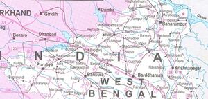
Jamtara, Dumka and Pakur districts of the state of Jharkhand lie at the western border of this district, whereas the border in other directions is covered by the districts of Bardhaman and Murshidabad of West Bengal.
Birbhum district is triangular in shape. River Ajay forms the southern base whereas the apex of the triangle points to the north. The river forms the boundary between the districts of Birbhum and Bardhaman. The state of Jharkhand is located at the northern and the western border of Birbhum and Murshidabad is located at the east.[8][9][10]
Rivers
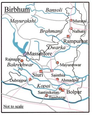
Several rivers flow across Birbhum. Some of these are Ajay, Mayurakshi (Mor), Kopai, Bakreshwar, Brahmani, Dwarka, Hinglo, Chapala, Bansloi, Pagla etc.[11][12]
Almost all the rivers originate higher up on the Chota Nagpur plateau and flow across Birbhum in a west–east direction. These rivers are furious during the monsoons but shrink during the dry summer months. The cyclical rotation of drought and floods of the rivers destroy lives and property, and adds to the difficulties of life in the district.
History
Birbhum is often called "The land of red soil",[13]
Birbhum is noted for its topography and its cultural heritage which is unique and is somewhat different from that of the other districts in West Bengal. The western part of Birbhum is a bushy region, a part of the Chhota Nagpur Plateau. This region gradually merges with the fertile alluvial farmlands in the east.
This district saw many cultural and religious movements in history. The Visva Bharati University at Santiniketan, established by Rabindranath Tagore, is one of the places Birbhum is internationally renowned for. Many festivals are celebrated in this culturally rich district, including the notable Poush Mela.[14]
The western portion of the district is historically known as Vajjabhumi or Bajrabhumi.[15][16] It is an undulating upland that is generally barren. The comparatively more fertile eastern portion, constituting the northeastern Rarh region, merges with the Gangetic plain. Vajjabhumi is also included in the Rarh region, and rest of Rarh is called Suhma to differentiate it from Vajjabhumi.[17][18]
The area now known as Birbhum was inhabited from pre-historic times. Some of the archaeological sites related to Pandu Rajar Dhibi of chalcolithic remains are located in Birbhum.[19] Stone age implements have been found at several places in the district.[20]
According to the old Jain book Acaranga Sutra, the last (24th) great Tirthankara Mahavira had wandered through this land, referred to as the "pathless country of Ladha in Vajjabhumi and Subbhabhumi (probably Suhma)" in the 5th century, B.C.[21][22][23]
According to some historians, the spread of Jainism and Buddhism in the Rarh region was part of the process of Aryanisation of the area.[24] Based on Divyabdan, a Buddhist text, Dr. Atul Sur has inferred that Gautam Buddha probably traversed this area to go to Pundravardhana and Samatata.[25]
The Rarh region, once a part of the Maurya empire was later included in the empires of the imperial Guptas, Shashanka and Harshavardhana. After dismemberment of Harshavardhana’s empire, the region was ruled by the Palas till 12th century AD, when overlordship of the area passed into the hands of the Senas.[26] During the rule of the Pala dynasty Buddhism, particularly the Vajrayana cult, flourished here.[27]
In 7th century A.D., the Chinese traveller Xuanzang described some of the monasteries he visited.[28][29]
References
- ↑ "Birbhum District". District Administration.
- ↑ O'Malley, L.S.S., "Bengal District Gazeteers - Birbhum", 1996 reprint, pp. 1-9, Govt. of West Bengal
- ↑ Maiti, Prakash Chandra, Birbhum in the Backdrop of Pre-history, Paschim Banga, Birbhum Special Issue, pp. 15–28
- ↑ O'Malley, L.S.S., "Bengal District Gazeteers - Birbhum", 1996 reprint, pp. 1-9, Govt. of West Bengal
- ↑ Maiti, Prakash Chandra, Birbhum in the Backdrop of Pre-history, Paschim Banga, Birbhum Special Issue, pp. 15–28
- ↑ O'Malley, L.S.S., "Bengal District Gazeteers - Birbhum", 1996 reprint, pp. 1-9, Govt. of West Bengal
- ↑ Maiti, Prakash Chandra, Birbhum in the Backdrop of Pre-history, Paschim Banga, Birbhum Special Issue, pp. 15–28
- ↑ Official Website of Birbhum district
- ↑ Mondal, Dipanwita, Ek Najare Birbhum Jela, Paschim Banga, Birbhum Special issue (in Bengali),February 2006, pp. 7–10
- ↑ O'Malley, L.S.S., "Bengal District Gazeteers - Birbhum", 1996 reprint, pp. 1-9, Govt. of West Bengal
- ↑ "Birbhum District". District Administration.
- ↑ Mondal, Dipanwita, Ek Najare Birbhum Jela, Paschim Banga, Birbhum Special issue (in Bengali),February 2006, pp. 7–10
- ↑ Rahim, Kazi MB, and Sarkar, Debasish, Agriculture, Technology, Products and Markets of Birbhum District, Paschim Banga, Birbhum Special Issue, pp. 157–166, Information and Cultural Department, Government of West Bengal
- ↑ Halim, Abdul, Birbhumer Sech Byabastha O Samaj Unnayan Parikalpana Samparke, Paschim Banga, Birbhum Special issue (in Bengali), February 2006, pp. 149–155
- ↑ Mukhopadhyay, Malay, Birbhum Jelar Bhougolik Parichiti, Paschim Banga, Birbhum Special issue (in Bengali), February 2006, pp. 29–32
- ↑ O'Malley, pp. 10-31
- ↑ Mukhopadhyay, Malay, Birbhum Jelar Bhougolik Parichiti, Paschim Banga, Birbhum Special issue (in Bengali), February 2006, pp. 29–32
- ↑ O'Malley, pp. 10-31
- ↑ Amalananda Ghosh (1990). An Encyclopaedia of Indian Archaeology: Volume 1: Subjects. Volume 2: A Gazetteer of Explored and Excavated Sites in India. BRILL. p. 237. ISBN 90-04-09264-1.
- ↑ "Prehistoric tools unearthed in Bengal". Stone Pages Archaeo News. 2005-12-24
- ↑ http://birbhum.gov.in/
- ↑ O'Malley, pp. 10-31,
- ↑ "Prehistoric tools unearthed in Bengal". Stone Pages Archaeo News. 2005-12-24.
- ↑ Ray, Nihar Ranajan, p.283
- ↑ Bangla O Bangalir Bibartan, (An Ethno-Cultural History of Bengal) by Dr. Atul Sur, (Published by Sahityalok, Kolkata, 1986, 1994)
- ↑ "Birbhum District". District Administration.
- ↑ Ghosh, Binoy, Paschim Banger Sanskriti, 1976 edition, Vol I, p. 287, Prakash Bhawan
- ↑ O'Malley, pp. 10-31,
- ↑ Bangla O Bangalir Bibartan, (An Ethno-Cultural History of Bengal) by Dr. Atul Sur, (Published by Sahityalok, Kolkata, 1986, 1994)
Back to West Bengal/Jat Villages

