Musandam
| Author:Laxman Burdak, IFS (R) |


Musandam is a governorate of Oman.
Variants
- Musandam (Arabic: مُحَافَظَة مُسَنْدَم, romanized: Muḥāfaẓat Musandam)
- Musandam Peninsula
- Cape Mussendom
- Mussendom
- Musanda
Jat Gotras Namesake
- Musa = Musandam (Pliny.vi.32)
Location
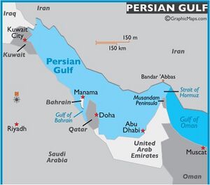
With the exception of the exclave of Madha,[1] it is located on the Musandam Peninsula, which juts into the Strait of Hormuz, the narrow entry into the Persian Gulf, from the Arabian Peninsula. The Governorate is also an exclave, separated from the rest of Oman by the United Arab Emirates. Its location gives Oman partial control, shared with Iran, of the strategic strait. In the northern section of Musandam, around Kumzar, the language is Kumzari, which is a southwestern Iranian language closely related to Larestani and Luri. The Musandam Peninsula has an area of 1,800 km2 and a population of 31,425 people.
Access to the peninsula was formerly difficult, with the only options being limited flights or a ten-hour drive through four immigration posts. The Shinas fast ferry service between Muscat and Musandam was launched in August 2008 to alleviate this problem and make the region more accessible.[2] The governorate is accessible by land only from the United Arab Emirates. Mainland Musandam can be accessed by Ras al-Khaimah near Al-Jeer, and an exclave of Sharjah, Dibba Al-Hisn. Oman Air provides an air link between the capital of the country, Muscat, and the main administrative town of the governorate, Khasab.
The area became part of Oman after a British invasion in 1971 to bring it under the control of the Oman regime of Sultan Qaboos, who took power after a British-backed coup against his father.[3]
Provinces
Musandam Governorate consists of four provinces:[4]
- Khasab, the regional centre of the Governorate
- Bukha
- Dibba Al-Bay'ah
- Madha, itself an exclave, located half-way between the rest of Musandam and Oman proper
The area has great strategic importance owing to its proximity to the Strait of Hormuz. The administrative head of Governorate is governor and minister of state.
Geography
The rugged coastline resembles the glacier-carved coasts of polar regions, but in this case, the coast was shaped by the movement of Earth's crust. The Arabian plate is slowly pushing under the Eurasian plate, creating the earthquake-prone mountains of Iran. On the leading edge of the Arabian plate, the Musandam Peninsula is sinking. The higher elevation mountains remain above the water, but the sea has rushed in to fill the valleys with fingers of water.[5]
Mention by Pliny
Pliny [6] mentions Arabia.....Beyond this (Catharrei = Qatar), the navigation is impracticable on that side,21 according to Juba, on account of the rocks; and he has omitted all mention of Batrasave22, a town of the Omani, and of the city of Omana23, which former writers have made out to be a famous port of Carmania24; as also of Homna and Attana, towns which at the present day, our merchants say, are by far the most famous ones in the Persian Sea.
22 Considered by modern geographers to be identical in situation with the Black Mountains and the Cape of Asabi, and still marked by a town and district named Sabee, close to Cape Mussendom.
23 In the modern district still called Oman.
24 On the opposite coast.
History
References
- ↑ Lancaster, Fidelity; Lancaster, William (2011). Honour is in Contentment: Life Before Oil in Ras Al-Khaimah (UAE) and Some Neighbouring Regions. Berlin, New York: Walter de Gruyter. pp. 3–265. ISBN 978-3-1102-2339-2.
- ↑ "Oman launches high-speed ferry". Gulf News. 26 July 2008.
- ↑ "Stealing a nation – the secret SAS mission to capture the Middle East's oil artery • Declassified UK". Declassified UK. 22 October 2021.
- ↑ Lancaster, Fidelity; Lancaster, William (2011). Honour is in Contentment: Life Before Oil in Ras Al-Khaimah (UAE) and Some Neighbouring Regions. Berlin, New York: Walter de Gruyter. pp. 3–265. ISBN 978-3-1102-2339-2.
- ↑ "Musandam Peninsula, Oman". NASA Earth Observatory. 15 April 2009.
- ↑ Pliny.vi.32

