Chandil
| Author:Laxman Burdak, IFS (R) |

Chandil (चांडिल) is a town and block in Saraikela Kharsawan District of Jharkhand State, India. Chandil is “part of the southern fringe of the Chhotanagpur Plateau and is a hilly upland tract”.
Variants
Location
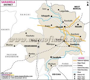
Chandil is a Town in Chandil Block in Saraikela Kharsawan District of Jharkhand State, India. It is located 37 KM towards North from District head quarters Seraikela. It is a Block head quarter. Chandil Pin code is 832401 and postal head office is Chandil. Lupungdih ( 4 KM ) , Gunda ( 5 KM ) , Tilla ( 8 KM ) , Bhadudih ( 8 KM ) , Tengadih ( 9 KM ) are the nearby Villages to Chandil. Chandil is surrounded by Chandil Block towards west , Gamarhia Block towards South , Ichagarh Block towards west , Balarampur Block towards East . Chandil , Jamshedpur , Purulia , Barughutu are the nearby Cities to Chandil. [1]
History
Jat clans
Following Jat clans have similarity with places shown in bold in this tahsil/block. There is need to further research this correlation.
Villages in Chandil block
Asanbani, Bhadudih, Chandil, Chawlibasa, Chilku, Couka, Dhunaburu, Ghoranagi, Hensakocha, Jhabri, Kapali E.n., Kapali E.s, Kapali W.n , Kapali W.s, Khunti, Matamdih , Rasuniya, Ruchap, Rudiya, Tamulia, Urmal,

