Chandrapur Chhattisgarh
| Author: Laxman Burdak IFS (R) |

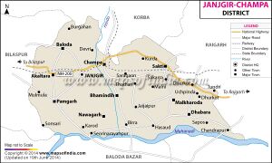
Chandrapur (चंद्रपुर) is a town in Dabhara tahsil of Janjgir-Champa district in Chhattisgarh. Chandrapur is part of newly formed Sakti district on 15 August 2021. Mand River meets Mahanadi near Chandrapur.
Variants
Location
Chandrapur is a Village in Dabhara Tehsil in Janjgir-Champa District of Chattisgarh State, India. It is located 61 KM towards East from District head quarters Janjgir, 17 KM from Dhabhara, 203 KM from State capital Raipur Chandrapur Pin code is 495692 and postal head office is Chandrapur (Janjgir-champa). Chandali ( 3 KM ) , Palsada ( 4 KM ) , Latesara ( 6 KM ) , Balpur ( 7 KM ) , Amalipali ( 8 KM ) are the nearby Villages to Chandrapur. Chandrapur is surrounded by Pussore Tehsil towards East , Sarangarh Tehsil towards west , Baramkela Tehsil towards South , Raigarh Tehsil towards North . Raigarh , Sakti , Bargarh , Basna are the near by Cities to Chandrapur.[1]
Jat Gotras Namesake
History
माँड नदी
माँड नदी: सरगुजा जिले के मैनपाट से निकलकर यह रायगढ़, सरगुजा, जांजगीर जिलों में बहती हुई चन्द्रपुर (जिला सक्ती, छत्तीसगढ़) के निकट महानदी में मिल जाती है । रायगढ़ जिले में इसकी लम्बाई 174 किमी. तथा अपवाह क्षेत्र 4.033 वर्ग किमी. है।[2]
Notable persons
External links
References
Back to Chhattisgarh

