Dhanbad

Dhanbad (धनबाद) is a city and district in the Indian state of Jharkhand. It is the largest city in Jharkhand.
Dhanbad - the Coal Capital of India
Dhanbad is famous for its coal mining, has some of the largest mines in India and is called Coal Capital of India. Tata Steel, Bharat Coking Coal Limited (BCCL), Eastern Coalfields Limited (ECL) and Indian Iron And Steel Company (IISCO) are some of the companies who operate coal mines in the district.
Origin of name
Originally the name of Dhanbad was Dhanbaid which seems to have been derived from the word Dhan (paddy) and baid, i.e., the paddy land. However, some claim that the name 'Dhanbad' is derived from "Dhan (धन) + Abad (आबाद)" meaning prospered with wealth. The Dhanbad originated from the district of Manbhum occupied by Mundari or Kolarian races in the wilderness of South undivided Bihar. In the seventh century A.D. some information is available from the account of the travels of Hieun Tsang. These accounts narrate existence of a powerful kingdom which comprised the district and adjoining areas, ruled by Sasanka.[1]
Location
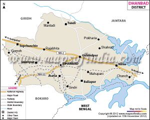
It shares its boundaries with West Bengal in the Eastern and southern part, Dumka & Giridih in the North and Bokaro in the west. Dhanbad comes under the Chota Nagpur Plateau.
Rivers : Damodar River is the main river flowing through the district. Katri, Jamunia, Gobai, Khudia and Irji are the other rivers flowing through the district.
History
There are records of settlements in the area from the 7th century.
The present district used to be a part of Manbhum. In the Settlement Report for Manbhum (1928) it was stated that no rock inscriptions, copper plates or old coins were discovered and not a single document of copper plate or palm leaf was found, during the Survey and Settlement operations. The oldest authentic documents produced were all on paper and barely even a hundred years old.[5]
Administrative Divisions
Administrative set-up of the district includes eight (8) development blocks, twelve (12) police stations and 1370 villages. Dhanbad , Jharia, Katras, Sindri, Gomoh, Gobindpur, Baliapur, Nirsa, Kumardubi, Chirkunda, Dumarkunda, Panchet and Mython are the urban centre of the district. [2]
Dhanbad district forms a part of Chhotanagpur plateau and has two physical divisions - Southern and Northern. The landscape of the southern portion is the area of the isolated hills and villages. The natural slope of the district have an easterly and southeasterly direction. The district drained by the rivers Damodar, Barakar, Khudia and Katri Nadi. [3]

