Dharmapuri
| Author:Laxman Burdak, IFS (R) |


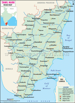
Dharmapuri (धर्मपुरी) is a city and district in the western part of Tamil Nadu, India. It is located on Ram Van Gaman Path.
Location
The city is located at 126 km from Bangalore, 200 km from Coimbatore, 260 km from Mysore, and 300 km from Chennai. It is located between latitudes N 11 47’ and 12 33’ and longitudes E 77 02’ and 78 40’.
Origin
Variants
- Dharmapuri (धर्मपुरी) (AS, p.464)
History
The region is believed to have been controlled by the Pallava dynasty in the 8th century. The Rashtrakutas took over in the 9th century. They were defeated by the Cholas in the 11th century, and subsequently the district came under the Chola sphere of governance.
During 18th century present day Dharmapuri district was part of the Kingdom of Mysore and was called Baramahal. As part of the Treaty of Seringapatam (signed on 18 March 1792) after the Third Anglo-Mysore War, Tipu Sultan agreed to give part of his territories including present-day Dharmapuri district to the British East India Company which was then merged into the Madras Presidency an administrative subdivision of British India.
It was part of the Salem District under British rule, until the founding of Dharmapuri district on 2 October 1965. The Dharmapuri district was split into Dharmapuri and Krishnagiri districts in 2004.[1] Many historical rock sculptures are found in this district. Modhur, a village near Dharmapuri has remains that date back to the Neolithic age. A government museum in Dharmapuri city displays some of these significant sculptures.
धर्मपुरी
विजयेन्द्र कुमार माथुर[2] ने लेख किया है ...1. Dharmapuri (धर्मपुरी) (AS, p.464) = धरमपुरी (मध्य प्रदेश) इस स्थान से पूर्व मध्यकालीन इमारतों के अवशेष मिले हैं.
2. धर्मपुरी (AS, p.464) = जिला करीमाबाद आंध्र प्रदेश गोदावरी के दाहिने तट पर प्राचीन तीर्थ है जहां वार्षिक यात्रा होती है. मुख्य स्मारक एक प्राचीन काल का मंदिर है.

