Jagatsinghpur
| Author: Laxman Burdak IFS (R) |

Jagatsinghpur (जगतसिंहपुर) is a town and a District in the state of Orissa, India.
Location
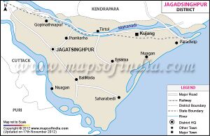
Jagatsinghpur is situated on an elevation of 15 metres (49 feet). It is the smallest district in the state and covers a landmass of 1759 km2. The place lies between 86°3' to 86°45' East Longitude and between 19°58' to 20°23' North latitude. It is bounded by Kendrapara district in North, Puri district in the South, Bay of Bengal in the East and Cuttack district in the West. Four major rivers of Odisha irrigate the mainland of Jagatsinghpur. These are the Mahanadi, Kathajodi, Devi and Biluakhai. Mahanadi is the longest river in Jagatsinghpur.
History
History of Jagatsinghpur comprises the conglomeration of Hindu, Muslim, Maratha and British realms. The Maratha administration kept the place under their jurisdiction and appointed Jagat Singh in 1748 to collect revenue. He collected the peshkush and Nazrana and remained an unchallenged and uninterrupted administrator for a pretty long period. The place was converted from Hariharpur to Jagatsinghpur after the name of Jagat Singh since 1786.
Administration
This district was subdivided into 8 Tehsils, they are Jagatsinghpur, Kujang, Tirtol, Balikuda, Biridi, Naugaon, Ersama and Raghunathpur.
External links
References
Back to Jat Kingdoms in Ancient India/Jats in Buddhism
Back to Orissa

