Khuzdar
Khuzdar (Balochi: خضدار ) is a city and also name of a district located in the centre of Balochistan province of Pakistan. Khuzdar is the capital of Khuzdar district. The area was originally part of Kalat District until Khuzdar was established on 1 March 1974.
Origin of name
Location
The city of Khuzdar is situated on National Highway linking Pakistan, Iran and Turkey. It is at a distance of about 400 km from Karachi and 300 km from Quetta, both of them being main cities of the country.
Tahsils
The district is administratively subdivided into four tehsils, which include 40 union councils:
- Khuzdar
- Nall Khuzdar Balochistan
- Wadh
- Zehri
History
During the Arab rule this region formed the province of Turan and Khuzdar was the capital. It was an important cantonment and was the headquarters of the Arab General Commanding the Indian frontier. Later Khuzdar became a part of the Kalat State. It was the scene of a battle between the people of Jhalawan and the Khan of Kalat in 1869. The Khan of Kalat Mir Khuda Khan was victorious and built here a fort of painted pottery. Close to the town are the ruins of an old fort built by the Arabs. Khuzdar is the capital of Khuzdar district. It is a district and divisional headquarters town in Balochistan. Previously party of the Kalat district, Khuzdar was upgraded as a separate district on 1 March 1974. The district is subdivided into three tehsils: Khuzdar, Naal and Wadh. It is at the apex of a narrow valley at an elevation of 1,237 m (4.000 feet). Over 99% of the people of the area are Muslims. The population of Khuzdar district is estimated to be over 525,000 in 2005.
The major tribes in the district are Bizenjo, Mardoi Jattak, Hasni, Nausherwani, Zehri, Mengal, Zarakzai, Ahmadzai. A large military complex is near completion near Khuzdar, which would make it the second largest Cantonment in Balochistan after Quetta. A university is established at the outskirts of Khuzdar, known as the heart of Balochistan. The city of Khuzdar is situated on National Highway linking Pakistan, Iran and Turkey. It is at a distance of about 400 km from Karachi and 300 km from Quetta, both of them being main cities of the country. The city is facilitated with an airport, near the university. The former college, now university is constructed on the foot-hills and is spread over an area of 200 acres (0.81 km2).
Heritage: The Ruined Forts Of Khuzdar

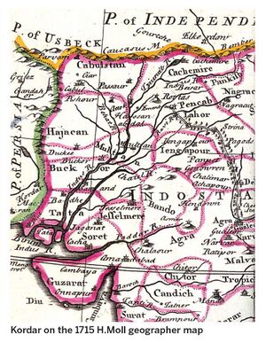
Sheikh Javed Ali Sindhi[1]writes....Described as Choarene by Greek historians, Khuzdar has played a significant role in the history of Balochistan. The city of Khuzdar is situated in a narrow, fertile, well-watered and highly cultivated valley in the Jhalawan area of Balochistan. The original inhabitants of Jhalawan known as Jats called it Kohiar. Khuzdar appears as Chiryan on the 1680 William Baffin and the 1740 Seutter maps of India and as Kordar on the 1715 H. Moll geographer map of India.
In the seventh century AD, when Arab troops conquered the region, Khuzdar came under the influence of Islam. The word Khuzdar has been derived from two Persian words qaz and dar meaning the place of silk. However, according to Sultan Ahmed Shahwani, the station director of Radio Pakistan Khuzdar, Khuz is an Arabic word which means ‘take firmly’ or ‘retain forever’ while dar means place. According to research by the late Maulana Muhammad Din Mareez Hijazi, a local religious scholar, Arabs renamed the city from Qazdar to Khuzdar for its beauty. Shah Abdul Latif Bhitai who travelled through Nal, Khuzdar and Qalat, praises the beauty of Jhau Valley, Khuzdar, in Shah Jo Risalo.
Arab geographer Ibn-i-Hawqal Al Baghdadi (979 AD) writes that “The city of Khuzdar was the capital of Tooran. It was located near the bank of a river. The fort was in the middle of the city, and the surrounding areas were beautiful, with gardens, orchards and other agricultural locations.” (Ancient Pakistan: Vol XXVI, 2015). In 986 AD, Mueen Bin Ahmed, an Arab by origin was the governor of Khuzdar. The city was divided into two parts. One part was used for the governor’s residence while the other part was allocated for general public and merchants. A route from Iran through north-west Balochistan connected Kalat, Khuzdar, Qandabil and Multan. A caravan route also connected Khuzdar with Sehwan in Sindh. When the Arab dynasty declined, Abu Mansoor Nasir-ul-Din Sabuktigin, the founder of the Ghaznavid dynasty (977-997) conquered Khuzdar from the Arabs.
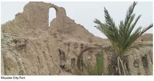
There are ruins of four forts in Khuzdar, namely the Kohiar Fort, the Halwai Peak Fort, the Shahi Bagh Fort and Khan Khudadad Khan Fort.
The Kohiar Fort of Khuzdar, located on the Meeri Buth hilltop in Union Council Obhan, was constructed by the Sassanid governors of Sindh with stone and mud, and covered an area of approximately 10 acres, from where the entire city of Khuzdar was clearly visible. The walls were three feet wide which can still be seen. The fort was repaired under the patronage of the Arab governors.
With the passage of time, the fort was destroyed to protect the area, according to the ‘Balochistan District Gazetteer Series, Jhalawan, (1907)’, and a new strong fort was built on Halwai, a mountain peak in the neighbourhood of the city. It later came to be known as the Halwai Peak Fort as it overlooked the valley now known as Halwai. This fort was destroyed by an earthquake and a new fort was built to protect the city walls in the present day Shahi Bagh area.

In ‘A Gazetteer of the Countries Adjacent to India, (Vol: 1, London, 1844)’ Edward Thornton writes, “It is enclosed by a mud wall, and close to it is a ruinous mud fortress.” Captain Charles Masson, an East India Company soldier and explorer, found only 60 to 70 mud houses in this place just before the fall of Kalat to the British. Masson was the first European to discover the ruins of Harappa, an archaeological site in district Sahiwal, Punjab. He also excavated 50 Buddhist sites around Kabul in Afghanistan.
After the death of Mir Nasir Khan II, in November 1857, Mir Khudadad Khan, the brother of the deceased ruler succeeded him to the Khanship of Kalat. Khuzdar decayed in 1860. Dr H. Cook visited Balochistan and studied its antiquities while he was employed in the British government. Masson referred to Cook’s work when he compiled his book The Country of Balochistan published in London in 1877. According to Cook, there were only 200 houses with about 900 people.
In the past, the Shahi Bagh Fort with its gardens stood on 20 acres of land. Now, only two parts of the fort, including the 20-feet high towers and five-feet-high walls exist in ruins, which can presently be seen from the Khuzdar-Karachi road. Some Hindu temples still lie in the neighbourhood of the fort area. Pieces of pottery have been found from the surface of the site. Many government buildings have been constructed on the site of Shahi Bagh Fort, located in Lizo Union Council, tehsil Khuzdar. Findings from the site suggest that this fort is at least 300 years old.

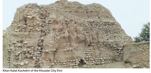
The Khan Khudadad Khan Fort of Khuzdar is located in the heart of the city on Muhammad Ali Jinnah Road. It was built by Khan-i-Qalat, Mir Khudadad Khan Ahmedzai. In 1872, when Dr Bellew from the Bengal Medical Service passed through the area, he saw a small collection of inhabited huts, among many uninhabited ones. There is a fort at a short distance from Khuzdar town, about which Bellew says in his diary: “... is an oblong with the bastions at the angles, and a fortified gateway in the west face. It was built in 1871 to protect the caravan routes converging at this spot. The garrison consists of 50 regular infantry, and 60 Brahui levies, with a few artillerymen and two guns.” This description of Khuzdar Fort is also given by Masson in his book The Country of Balochistan, (1877).
Captain P. J. Maitland also visited this fort in 1881-82 during his journey from Jacobabad to Panjgur. He described a well in the fort which was 10 to 50 feet deep. The fort contained residences of his deputy, servants and the infantry. The total area of the Khuzdar City Fort is four acres. The walls constructed with mud and stone are six feet wide and 12 feet high. Presently, the fort area is divided into four parts where government buildings, including the tehsildar’s office, police station, Levies headquarters and the Balochistan Constabulary are housed. The fort has bastions, a kachehri (court) and a mosque. There are some trees and shrubs inside the fort. Mostly the forts have been destroyed by rains, the land mafia and antique dealers and neglected by the department of archaeology of the government of Balochistan. There is an urgent need to investigate, document and preserve these sites of historic significance that would bring tourism to this part of Balochistan.
Published in Dawn, EOS, October 6th, 2019
Notable persons
External links
References
Back to Jat Places in Pakistan

