
Kiriburu
| Author:Laxman Burdak, IFS (R) |

Kiriburu(किरीबुरु) is a census town in Jharkhand in West Singhbhum district of Jharkhand. But Kiriburu hills stand aloof in Odisha’s district of greenery, Keonjhar. Kiriburu is famous for its Iron-ore mine governed by the Steel Authority of India Limited (SAIL). The towns of Kiriburu and Meghahatuburu are contiguous, sharing many local facilities. It is also a famous hill station situated in the core of Saranda forest. Author visited the place on 19.1.1981.
Variants
Location
Kiriburu lies adjacent to Jharkhand’s Meghatuburu hills. Kiriburu is a paradise less known. Know more about Keonjhar’s Cherrapunji!
Kiriburu - At a height of 2800 feet Kiriburu is a lovely place in Saranda. Giving the picture of a hill station it provides an opportunity to witness the vast tract of Saranda and its hills from a single point. One such point is the ‘view point’ of the SAIL Guest house.[1]
Origin
The word ‘Kiri’ means ‘Elephant’ and ‘Buru’ means ‘Hill’ which rightfully describes Kiriburu as the ‘Hill of Elephants’ as it provides shelter to an enormous number of wild elephants.
History
Kiriburu and Meghahatuburu, the twin hills that spreads across the two states of Jharkhand and Odisha are the most underrated and undiscovered places.
Kiriburu hill is located at Kiriburu, a town in West Singhbhum district of Jharkhand but also stretches a little in the Kendujhar district of Odisha, and therefore, most of the tourist places to visit in Kiriburu lies in Odisha.[2]
Meghahatuburu hill on the other hand is located at Meghahatuburu, a town in West Singhbhum district of Jharkhand.[3]
The word ‘Kiri’ means ‘Elephant’ and ‘Buru’ means ‘Hill’ which rightfully describes Kiriburu as the ‘Hill of Elephants’ as it provides shelter to an enormous number of wild elephants.
Meghahatuburu derives its name from the word ‘Meghata’ which means ‘Clouds’ thus citing it as a ‘Hill of Clouds’, as it remains covered under layers of clouds most time of the year. Meghahatuburu is also often addressed to as ‘Cherrapunji of Jharkhand’. [4]
Due to the presence of iron ore in excess, the twin hills are also referred to as the ‘Iron Hills’. Kiriburu and Meghahatuburu both lie within the belt of the Saranda Forest and both the township are developed by the Steel Authority of India Limited (SAIL).
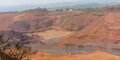
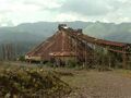
Kiriburu is a census town in Jharkhand. The town is mainly known for having big Iron-ore Mines KIOM (Kiriburu Iron-Ore Mine) & MIOM (Meghahatuburu Iron-Ore Mine) both governed by Steel Authority of India Limited (SAIL). The road connecting the township to the mines is divided by the border of Odisha and Jharkhand. It is also a famous hill station situated in the core of Saranda forest. Saranda forest is land of seven hundred hills. The name of the forest Saranda is due to the large number of elephants found in this forest (saranda means elephants). The forest has some good water falls and hill views. Kiriburu Iron ore Mines(KIOM) is one of the captive Iron ore Mines of Steel Authority of India Limited(SAIL). Iron ore is being mined and processed at the rate of 4.25 MT/Annum to meet the internal requirement of Bokaro Steel Plant and other Sister integrated Steel Plants operating under SAIL.
The towns of Kiriburu and Meghahatuburu are contiguous, sharing many local facilities. The official pin codes of Kiriburu and Meghahatuburu is 833222 And 833223 Most of the People work in SAIL Iron Ore Mines.
Meghahatuburu is a Forest village in West Singhbhum district of the Indian state of Jharkhand.

किरीबुरू भारत के झारखंड राज्य के पश्चिमी सिंहभूम ज़िले में स्थित एक हिलस्टेशन है। परंतु किरीबुरू की पहाड़ियाँ उड़ीसा प्रदेश के केओंझर जिले में पड़ती हैं। किरीबुरू के सनराइज और सनसेट पॉइंट प्रसिद्ध हैं। यहाँ छोटे झरने तथा पहाड़ियों का मनोरम दृश्य पर्यटकों के लिए काफी आकर्षण का केंद्र है। किरीबुरु और मेघाहातुबुरु दोनों जुड़वाँ शहर हैं। किरीबुरु को ऐसा स्वर्ग मानते हैं जिसके बारे में बाहरी दुनिया को बहुत कम जानकारी है। इसको केंवझर (उड़ीसा) जिले की चेरापूंजी भी बोलते हैं। 'किरु' का अर्थ होता है 'हाथी' और 'बुरु' का अर्थ होता है 'पहाड़'। हाथियों की बहुलता के कारण ही इसका नाम किरीबुरू पड़ा है। मेघाहातुबुरु का अर्थ है 'बादलों वाले पहाड़' क्योंकि अधिकांश समय यहाँ बादल छाए रहते हैं। इस स्थान को झारखंड का चेरापूंजी भी कहा जाता है। यहां पर आयरन खनिज की अधिकता होने के कारण इन दोनों को 'आयरन हिल' भी बोलते हैं। इनका विकास स्टील अथॉरिटी ऑफ इंडिया लिमिटेड (SAIL) द्वारा किया गया है।
-

किरीबुरू लौह अयस्क खदान
-

किरीबुरू लौह अयस्क खदान, सारंडा सुवन छात्रावास
-
किरीबुरू लौह अयस्क खदान
-
किरीबुरू लौह अयस्क खदान


Tourist Places in Kiriburu and Meghahatuburu
Kiriburu and Meghahatuburu are the hidden jewels of nature. The place is packed with greenery and has many waterfalls, adding to its scenic beauty. It is a perfect place for adventurers and explorers.
Here is the list of places to visit in Kiriburu and Meghahatuburu:
Saranda Forest: Saranda, the largest Sal (Shorea robusta) forest in Asia, stands proudly in the West Singhbhum district of Jharkhand and also stretches a little into the state of Odisha. The forest covers an area of 820 sq km and is home to a huge variety of wild animals. A large part of the forest is under the iron ore mining project. Saranda forest remained out of the tourist limelight for long, irrespective of nurturing many amazing places of tourist interest within its belt. Saranda is said to be the land of seven hundred hills.[5]
Saranda Forest is located in the border Odisha and Jharkhand covering both states. Saranda meaning Elephants derived its name due to presence of a large number of elephants within these thick forests. Kiriburu and Meghahatuburu, situated in Jharkhand are the most well-known destinations along Saranda Forest due to the presence of Iron Ore Mines governed by SAIL (Steel Authority of India Limited).[6]
Some of the wild animals found here are Wild Elephants, Sambar, Chital, Beers, Bison, Tigers, and Leopards. Although the forest is stuffed with a huge number of Sal (Shorea robusta) trees, some of the other trees which are also found in large numbers are Mangoes, Jamun, Jackfruit, Guava, Mahua, Kusum, Tilai, Harin Hara (Armossa Rohitulea), Gular (Ficus Glomerata), and Asan. River Karo and Koina flow through the forest, contributing to a variety of flora and fauna. Due to the presence of a high amount of iron ore, the soil in the entire forest is red in color. [7]
Pundul Waterfall: Pundul Falls is located in Kiriburu and is surrounded by the dense Saranda forest. The Karo River originates from the Pundul Falls. The path that leads to the fall is small and is fenced with Sal trees on both sides, hence, one has to walk their way to the falls. Walking down the beautiful path covered with sal trees will surely take away all your anxieties.[8]
Swapneswar Temple: Swapneswar Temple is located on the way to Pundul Falls. The temple has an idol of goddess Durga and also a shiva lingam. The mesmerizing sound of the Pundul falls can be heard from the temple. It is from this place, one has to start their on-foot journey for Pundul Falls.[9]
Khandadhar Waterfall: Khandadhar Waterfalls located at Sundergarh district of Odisha is the 12th highest waterfall in India. The waterfall falls from a height of 244 meters, giving it a shape of a sword, hence, the name Khandadhar. It derives its name from the word ‘Khanda’ which means a ‘sword’ and ‘Dhar’ means ‘Sharp’. The most breathtaking sight of the place is that the water, falls from a great height thus creating a cloudy appearance that sometimes gives birth to rainbows at the base of the falls. Khandadhar is 95.7 Kms from Kiriburu via Koida Rd and takes almost 3 to 3 and a half hours to reach. It is a perfect picnic spot as well so what can be better than packing some food on the way to have a mini picnic at Khandadhar.[10]
Sanaghagara Waterfall: Sanaghagara Waterfall is a small waterfall located in the Kendujhar district of Odisha. The fall got its name from the word ‘Sana’ which means ‘small’ and ghagra which means ‘waterfall’. True to its name, the small waterfall lies in the Keonjhar to Sambalpur National Highway, 5 km from the Kendujhar town. A small river named San Machakandana swiftly flows down the hill creating the natural waterfall.
Badaghahara Waterfall: Badaghahara Waterfall is also located at Kendujhar district of Odisha, 9 km from the town of Kendujhar and 3 km from Sanaghagara Waterfall. River Machha Kandana makes a single drop from the height of 200 feet, hence creating the waterfall. A dam has been constructed on the waterfall as it a perennial waterfall. The place is untouched for any commercial purpose hence one can enjoy nature here at its raw form. [11]
Handibhanga another waterfall located in Bahalda village of the Mayurbhanja district of Odisha is located at a distance of 45 km from the town of Kendujhar. The best time to visit Handibhanga is between the months of October to March. The height of the fall is almost 100 feet and is one of the best picnic spots in the region.
Jhikra waterfal: Jhikra waterfal is also known as the rainbow waterfall as the water creates a rainbow effect while dropping from a great height. The fall is in the middle of the sal forest which makes it look divine. The path leading to the waterfall is rocky with streams of water flowing which one has to cross to reach the spot.
Pachri falls: Pachri falls is another beautiful fall that should be on the list while on a Kiriburu Meghahatuburu trip. The falls lie between the dense forest and it is a 30 minutes walk through the rocky forest to reach the amazingly beautiful Pachri fall.
External links
References
- ↑ https://jharkhandstatenews.com/section/tourism/
- ↑ https://tripinfi.com/kiriburu-meghataburu-travel-guide/
- ↑ https://tripinfi.com/kiriburu-meghataburu-travel-guide/
- ↑ https://tripinfi.com/kiriburu-meghataburu-travel-guide/
- ↑ https://tripinfi.com/kiriburu-meghataburu-travel-guide/#Saranda-forest
- ↑ https://wotweb.com/wot-article/saranda-forest-light-shade-part-1/
- ↑ https://tripinfi.com/kiriburu-meghataburu-travel-guide/#Saranda-forest
- ↑ https://tripinfi.com/kiriburu-meghataburu-travel-guide/#Saranda-forest
- ↑ https://tripinfi.com/kiriburu-meghataburu-travel-guide/#Saranda-forest
- ↑ https://tripinfi.com/kiriburu-meghataburu-travel-guide/#Saranda-forest
- ↑ https://tripinfi.com/kiriburu-meghataburu-travel-guide/#Saranda-forest