Kurnool
| Author:Laxman Burdak, IFS (R) |

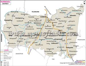
Kurnool (कुर्नूल) is a district and city in the Indian state of Andhra Pradesh. The city is often referred as The Gateway of Rayalaseema.[1] It was the capital of Andhra State from 1 October 1953 to 31 October 1956.
Variants
- Kanadelavolu (कनडेलावोलु) (कुरुनूल) (आ.प्र.) (AS, p.130)
- Kuranula कुरनूल (आ.प्र.) (AS,p.205)
- Kurunool (कुरुनूल)
- Kurnula (कुर्नूल)
- Kandanavooru
- Kandanavolu
Origin
Palaeolithic era: The name Kurnool is derived from Kandanavooru or Kandanavolu. The name Kandanavolu is combination of Kandana and volu. Kandana means grease. During the days when Bullock Cart is a form of transport, bullock cart riders used to stop on the banks of Tungabhadra River to apply grease to the bullock cart wheels before crossing the river. Hence the name 'Kandanavolu'.[2] Later the name formerly Kandanavolu changed to Kandanavooru, and then gradually to Kurnool.
History
The Ketavaram rock paintings from the Paleolithic era and are (18 kilometres from Kurnool). Also the Jurreru Valley, Katavani Kunta[3] and Yaganti in Kurnool District have some important rock art and paintings in the vicinity, may be dated from 35,000 to 40,000 years ago.
Belum Caves are geologically and historically important caves in the district. There are indications that Jain and Buddhist monks were occupying these caves centuries ago. Many Buddhists relics were found inside the caves. These relics are now housed in Museum at Ananthapur. Archaeological survey of India (ASI) found remnants of vessels and other artifacts of pre-Buddhist era and has dated the remnants of vessels found in the caves to 4500 BC.[4]
Vijayanagara era: Little was known about Kurnool town before the 11th century. The earliest knowledge of this settlement dates from the 11th century. It has developed as transit place on the southern banks of the river Tungabhadra.
Ruled by the Cholas in 12th Century and later taken over by the Kakatiya dynasty in 13th century. Kurnool developed into a transit point on the southern banks of the Tungabhadra River. It eventually fell under the rule of a jaghirdar before becoming a part of the Vijayanagar dynasty. King Achyuta Raya constructed the Kurnool Fort during the 16th century.
Mughals Rule: The Abyssinian, Abdul Wahab Khan, defeated King Gopal Raja of the Vijayanagar Kingdom in the 17th century and went on to rule the land for 16 years until his death.
In 1686, Kurnool fell under the influence of the Mughals who were ruled by Emperor Aurangzeb. Later on in Kurnool’s history, it was ruled by the Nawabs until the British Government took over in 1839. Kurnool was the capital of Andhra Pradesh between 1953 and 1956 until the modern day Telangana region was joined with the Andhra State to form Andhra Pradesh. Hyderabad was then made the state’s capital. After Andhra Pradesh once again became a separate state from Telangana, Kurnool remained a part of Andhra Pradesh.
The town became a vassal princely state of the Mughal empire under Aurangazeb, who took control in 1686. The town was the capital and seat of ruling Muslim princes, styled Nawabs.
कुरनूल
विजयेन्द्र कुमार माथुर[5] ने लेख किया है ... कुरनूल (आ.प्र.) (AS,p.205) - आन्ध्र प्रदेश में स्थित एक नगर है। इस नगर की स्थापना 11वीं शती में की गई थी। इसका प्राचीन नाम 'कनडेलाबोलू' है।
16वीं शती के पूर्वार्घ में विजयनगर साम्राज्य के अतंर्गत रहने के पश्चात् इसका पतन होने पर राजा रामराय के प्रपौत्र गोपालराय का यहाँ कुछ दिन तक अधिकार रहा था। बीजापुर के सुल्तान ने गोपालराय को हराने के लिए अपने अब्दुल बहाब नामक सेनापति को भेजा, जिसने कुरनूल पर अधिकार करके अपनी धर्मिक कट्टरता का परिचय दिया। उसने यहाँ के अनेक मंदिर तुड़वा कर मसजिदें बनवाईं। उसकी क़ब्र हंदल के मक़बरे में है, जो कुरनूल के पास ही है।
बीजापुर के सुल्तान के शासन काल में मराठा प्रमुख शिवाजी ने इस इलाके में चौथ वसूल की। मुग़ल बादशाह औरंगज़ेब के जमाने में बीजापुर राज्य की समाप्ति पर कुरनूल पर मुग़लों का अधिकार हो गया। बाद में मुग़ल साम्राज्य के शिथिल होने पर जब हैदराबाद की नई रियासत दक्षिण में बनी तो निज़ाम हैदराबाद ने कुरनूल को 18वीं शती के मध्य में अपने राज्य में सम्मिलत कर लिया। कुरनूल तुंगभद्रा और हांद्री नदियों के तट पर स्थित हैं। नगर के चारों ओर प्राचीन परकोटा है।
कनडेलावोलु
विजयेन्द्र कुमार माथुर[6] ने लेख किया है ... कनडेलावोलु (AS, p.130) आंध्र प्रदेश में है। कनडेलावोलु का प्राचीन नाम कुरुनूल, कुर्नूल है। कनडेलावोलु का अर्थ है, गाड़ी के पहिये में तेल डालने का स्थान। किंवदंती है कि कुरुनूल से आठ मील (लगभग 12.8 कि.मी.) दूर एक विशाल मंदिर बनाया जा रहा था; पत्थर ढोने वाली गाड़ियों के पहियों में तुंगभद्रा के इस पार ठहर कर गाड़ी वाले तेल डालते थे जिससे इस स्थान का नाम कनडेलावोलु पड़ गया। कालांतर में कनडेलावोलु बस्ती बन गई जिसका कनडेलावोलु का अपभ्रंश रूप कुरुनूल नाम पड़ गया।
External links
References
- ↑ Sarkar, Siddhartha (2011). International Journal of Economic and Political Integration: Vol.1, No.1. Universal-Publishers. p. 15. ISBN 978-1-61233-544-5.
- ↑ "Heritage in Kurnool". AP Tourism Department.
- ↑ Petraglia, Michael. "New rock art discoveries in the Kurnool District, Andhra Pradesh, India". academia.edu.
- ↑ Show Caves of India: Belum Caves
- ↑ Aitihasik Sthanavali by Vijayendra Kumar Mathur, p.205
- ↑ Aitihasik Sthanavali by Vijayendra Kumar Mathur, p. 130

