Lancashire
| Author:Laxman Burdak, IFS (R) |

.

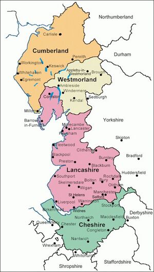
Lancashire (लैंकाशायर) is a county in North West England. Lancashire is a historic, ceremonial and non-metropolitan county and the county boundaries differ between these different forms. Its county town is Lancaster.
Variants
Location
Today, the county borders Cumbria to the north, Greater Manchester and Merseyside to the south, and North and West Yorkshire to the east; with a coastline on the Irish Sea to the west. The historic county's boundaries remain the same as those of the county palatine with Lancaster serving as the county town, and the Duke of Lancaster (i.e. the Queen) exercising sovereignty rights,[1] including the appointment of lords lieutenant in Greater Manchester and Merseyside.
History
During Roman times the area was part of the Brigantes tribal area in the military zone of Roman Britain. The towns of Manchester, Lancaster, Ribchester, Burrow, Elslack and Castleshaw grew around Roman forts. In the centuries after the Roman withdrawal in 410 AD the northern parts of the county probably formed part of the Brythonic kingdom of Rheged, a successor entity to the Brigantes tribe. During the mid-8th century, the area was incorporated into the Anglo-Saxon Kingdom of Northumbria from the north of the River Ribble and the Kingdom of Mercia from the south, which both became parts of England in the 10th century.
The historic County Palatine of Lancashire is still recognised today and includes the large cities of Manchester and Liverpool as well as the Furness and Cartmel peninsulas in the Lake District, and an area of 1,909 square miles (4,940 km2). Many of these places still identify strongly with the county, with Lancashire still being used as part of the postal address. The historic county was subject to a significant boundary reform for administrative purposes in 1974. This created the current ceremonial county and removed Liverpool and Manchester, and most of their surrounding conurbations, to form the metropolitan and ceremonial counties of Merseyside and Greater Manchester. The detached northern part of Lancashire in the Lake District, including the Furness Peninsula and Cartmel, was merged with Cumberland and Westmorland to form Cumbria. Administratively, Lancashire lost 709 square miles of land to other counties – about two fifths of its original area – although it did gain some land from the West Riding of Yorkshire. The historic county is celebrated in November on Lancashire Day.
The history of Lancashire begins with its founding in the 12th century. In the Domesday Book of 1086, some of its lands were treated as part of Yorkshire. The land that lay between the Ribble and Mersey, Inter Ripam et Mersam, was included in the returns for Cheshire. Lancashire emerged as a major commercial and industrial region during the Industrial Revolution. Liverpool and Manchester grew into its largest cities, with economies built around the docks and the cotton mills respectively.[2] These cities dominated global trade and the birth of modern industrial capitalism. The county contained several mill towns and the collieries of the Lancashire Coalfield. By the 1830s, approximately 85% of all cotton manufactured worldwide was processed in Lancashire.[3]A number of towns and cities were major cotton mill towns during this time. Blackpool was a centre for tourism for the inhabitants of Lancashire's mill towns, particularly during wakes week.
Rural Life

Britain’s diverse rural landscape has always offered itself to wide variety of uses including cereal growing, livestock, touring, hunting and forestry. Dry stone walled fields and moors near Chitheroe, Lankashire reflect age-old farming practices.[5]
लैंकाशायर
लैंकाशायर इंग्लैंड के उत्तर-पश्चिमी किनारे पर स्थित काउंटी है, जिसका क्षेत्रफल 1,866 वर्ग मील है। यह पश्चिम में आइरिश सागर से, पूर्व में यॉर्कशिर से, दक्षिण में चेशिर (Cheshire) काउंटी से तथा उत्तर में कंबरलैंड एवं वेस्टमरलैंड (Westmorland) काउंटी से घिरा हुआ है। इस काउंटी की तटरेखा अनियमित है। यहाँ के मुख्य प्रवेशद्वार मोरकैम बे (Morecambe Bay) और मर्ज़ि (Mersey) एवं रिब्ल (Ribble) नदियों के ज्वारनदमुख हैं। काउंटी का उत्तरी तथा पश्चिमी भाग पहाड़ी है।
लंकाशिर के कोयले का क्षेत्र मर्ज़ि तथा रिब्ल नदियों के मध्य के भूभाग में 400 वर्ग मील में फैला हुआ है। जहाज निर्माण करने के लिए प्रसिद्ध फर्नेंस (Furness) क्षेत्र में पर्याप्त लोहा मिलता है। लैंकाशिर सूती वस्त्र के लिए विश्वविख्यात है तथा अन्य प्रकार के भी वस्त्र यहाँ बनते हैं। यहाँ सभी प्रकार की मशीनों का भी निर्माण होता है। यहाँ सभी प्रकार की मशीनों का भी निर्माण होता है। स्लेट तथा फर्शबंदी के लिए पत्थरों का खनन यहाँ की खानों में होता है। कांउटी के प्रशासनिक नगर का नाम भी लैंकाशिर है, जहाँ नॉर्मन काल का ऐतिहासिक किला है। लैंकाशिर काउंटी में साबुन, मोमबत्ती, क्षार तथा काँच निर्माण करने के कारखाने हैं। दक्षिणी लैकाशिर में सूती वस्त्र उत्पादन करनेवाला प्रमुख जिला मैंचेस्टर है, जो संसार में सबसे, घना बसा हुआ क्षेत्र है।
14वीं शताब्दी में ऊनी तथा लिनेन वस्त्रों की बुनाई प्रारंभ होने पर, मैंचेस्टर का विकास प्रारंभ हुआ और 18वीं शताब्दी के मध्य में सूती वस्त्र के उद्योग का विकास आरंभ हुआ। इंग्लैड का दूसरा बंदरगाह तथा लिवरपूल में प्रथम डॉक 1700 ई. में खुला। यह डॉक मर्ज़ि नदी के साथ साथ सात मील तक चला गया है। लंदन के बाद लैकाशिर इंग्लैंड की सबसे घनी बसी हुई काउंटी है।
External links
References
- ↑ "County Palatine". Duchy of Lancaster.
- ↑ "Rivals: Liverpool v Manchester". BBC Liverpool. 13 May 2010.
- ↑ Gibb, Robert (2005). Greater Manchester: A panorama of people and places in Manchester and its surrounding towns. Myriad. p. 13. ISBN 1-904736-86-6.
- ↑ Rural Britain Then and Now : A Celebration of the British Countryside Featuring Photographs from the Francis Frith Collection by Roger Hunt, Forward by Sir Simon Jenkins, 2009, by Bounty Books, isbn:978-0-753719-53-4, p.109
- ↑ Rural Britain Then and Now : A Celebration of the British Countryside Featuring Photographs from the Francis Frith Collection by Roger Hunt, Forward by Sir Simon Jenkins, 2009, by Bounty Books, isbn:978-0-753719-53-4 ,p.21

