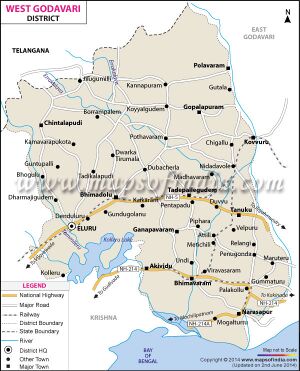
Narsapur
| Author:Laxman Burdak, IFS (R) |

Narsapur (नरसापुर) is a town in West Godavari district of the Indian state of Andhra Pradesh, India.
Origin
Narsapur was also known as "Nrisimhapuri", named after the Lord Narasimha.[1] Gradually it changed into Narasimhapuram and now to Narasapuram.
Variants
- Narasapura (नरसापुर) (जिला राजमहेन्द्री, आंध्रा प्रदेश) (AS, p.479)
- Narasapuram (नरसापुरम)
Location
The town is situated on the banks of the Vasista Godavari River. Narsapur is located at 16.4361°N 81.7016°E and on the right bank of Vasista Godavari River at an altitude of 0 m (0 ft). The River Godavari empties into Bay of Bengal near Antarvedi, at 9.6 km from Narsapur.[2]
History
The existence of Narsapur dates back to 1173 AD. Dutch people landed in Narsapur in 1626. Narsapur was used as a port by the Dutch and ships and boats were built here. It was noted for its ship building activity and some of the Europeans also were customers at this place; small boats are still built in Narsapur. In the 16th century, Portuguese established their own factory which remained as a trading centre for a few years. In the 18th century, Narsapur became an important trading port. From this port, teak was exported to other regions. The ports at Kakinada and Narsapuram became famous for manufacturing ships. At present there is no port handling at Narsapur.
नरसापुर
विजयेन्द्र कुमार माथुर[3] ने लेख किया है ...नरसापुर (AS, p.479) राजमहेन्द्री, आंध्र प्रदेश राज्य के निकट बसा हुआ एक नगर है। गोदावरी की सात धाराओं में से अंतिम वशिष्ठ धारा इस स्थान के निकट [p.480]:बहती हुई मानी जाती है इसका प्राचीन नाम अंतर्वेदी कहा जाता है. (टि. अंतर्वेदी शब्द दोआबे का पर्याय है).
यह पश्चिमी गोदावरी ज़िले में, गोदावरी नदी के 'वशिष्ट' नामक मुहाने पर नदी के डेल्टा प्रदेश में एलूरू से 45 मील (लगभग 72 कि.मी.) पूर्व-दक्षिण-पूर्व की ओर स्थित है। नरसापुर रेलवे का अंतिम स्टेशन है. (दे.गोदावरी)
External links
References
- ↑ "Layout page". areaprofiler.gov.in
- ↑ "Guntur District Mandals" (PDF). Census of India. pp. 460, 470.
- ↑ Aitihasik Sthanavali by Vijayendra Kumar Mathur, p.479-480

