Pachangi
| Author:Laxman Burdak, IFS (R) |

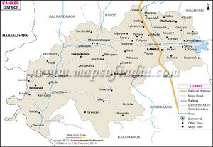
Pachangi (पचांगी) is a village Bhanupratappur (now Durgkondal) tahsil of Kanker district in Chhattisgarh. Author (Laxman Burdak) visited it on 18.04.1986, 11.12.1986, 23.02.1987.
Variants
Jat Gotras Namesake
- Pachan = Pachangi, a village Bhanupratappur (now Durgkondal) tahsil of Kanker district in Chhattisgarh.
Origin
Location
It is situated 32km away from sub-district headquarter Durgkondal (tehsildar office) and 97km away from district headquarter Kanker. According to Census 2011 information the location code or village code of Pachangi village is 447724. Pachangi village is located in Durgkondal tehsil of Uttar Bastar Kanker district in Chhattisgarh, India. As per 2009 stats, Pachangi village is also a gram panchayat. The total geographical area of village is 1000 hectares. [1]
History
Notable persons
Population
Pachangi has a total population of 819 peoples, out of which male population is 424 while female population is 395. Literacy rate of pachangi village is 44.32% out of which 51.42% males and 36.71% females are literate. There are about 186 houses in pachangi village. Pincode of pachangi village locality is 494771. When it comes to administration, Pachangi village is administrated by a sarpanch who is elected representative of the village by the local elections. As per 2019 stats, Pachangi village comes under Bhanupratappur assembly constituency & Kanker parliamentary constituency. Bhanupratappur is nearest town to pachangi for all major economic activities, which is approximately 60km away.[2]

