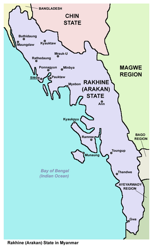
Rakhine
| Author: Laxman Burdak IFS (R) |

Rakhine (Hindi:रखाइण, /rəˈkaɪn/; Burmese: ရခိုင်ပြည်နယ်), formerly Arakan, is a state in Myanmar (Burma). Its capital is Sittwe.
Variants of name
- Rakhine State
- Rakkhapura (Pali)
- Rakshapura (Sanskrit)
- MLCTS: ra.hkuing pranynay
- Rakhine pronunciation [ɹəkʰàiɴ pɹènè];
- Burmese pronunciation: [jəkʰàiɴ pjìnɛ̀];
Location
Situated on the western coast, it is bordered by Chin State to the north, Magway Region, Bago Region and Ayeyarwady Region to the east, the Bay of Bengal to the west, and the Chittagong Division of Bangladesh to the northwest. It is located approximately between latitudes 17°30' north and 21°30' north and longitudes 92°10' east and 94°50' east. The Arakan Mountains, rising to 3,063 metres at Victoria Peak, separate Rakhine State from central Burma. Off the coast of Rakhine State there are some fairly large islands such as Cheduba and Myingun Island.
Etymology
The term Rakhine is believed to have been derived from the Pali word Rakkhapura (Sanskrit Rakshapura), meaning "Land of Ogres" (Rakshas), possibly a pejorative referring to the original Negrito[3] Australoid inhabitants. The Pali word "Rakkhapura" ("Rakkhita") means "land of the people of Rakhasa" (also Rakkha, Rakhaing). They were given this name in honour of their preservation of their national heritage and ethics or morality.[4] The word Rakhine means, "one who maintains his own race".[5] In the Rakhine language, the land is called Rakhinepray, the ethnic Rakhine are called Rakhinetha.
The term Arakan, used in British colonial times, is believed to be a Portuguese corruption of the word Rakhine that is still popularly used in English. Many English language users[note 1] eschew the name changes promulgated by the military government.
History
The history of the region of Arakan (now renamed Rakhine) State can be roughly divided into seven parts. The first four divisions and the periods are based on the location of the centre of power of the main independent Rakhine-dominated polities in the northern Rakhine region, especially along the Kaladan River. Thus, the history is divided into the Dhanyawadi, Waithali, Laymro and Mrauk U. Mrauk U was conquered by the Konbaung dynasty of Burma in 1784–85, after which Rakhine became part of the Konbaung kingdom of Burma. In 1824, the first Anglo-Burmese war erupted and in 1826, Rakhine (alongside Tanintharyi) was ceded to the British as reparation by the Burmese to the British. Rakhine thus became part of the province of Burma of British India. In 1948, Burma was given independence and Rakhine became part (colony) of the new federal republic.
Independent kingdom
Based on Rakhine oral histories and inscriptions in certain temples, the history of the Rakhine region dates back nearly five thousand years.[citation needed] The Rakhine people trace their societal history back to as far as 3325 BCE and have given a lineal succession of 227 native monarchs and princes[6] down to the last ruler in 1784. They also describe their territory as including, in varying points of time, the regions of Ava, the Irrawaddy Delta, the port town of Thanlyin (Syriam) and parts of eastern Bengal. However, the expanse of the successive Rakhine kingdoms does not exactly corroborate with certain known historical documentation.[citation needed]
According to Rakhine legend, the first recorded kingdom, centred around the northern town of Dhanyawadi, arose in the 34th century BCE and lasted until 327 CE. Rakhine documents and inscriptions state that the famed Mahamuni Buddha image was cast in Dhanyawady in around 554 BCE when the Buddha visited the kingdom. After the fall of Dhanyawadi in the 4th century CE, the centre of power shifted to a new dynasty based in the town of Waithali. The Waithali kingdom ruled the regions of Rakhine from the middle of the 4th century to 818 CE. The period is seen as the classical period of Rakhine culture, architecture and Buddhism, as the Waithali period left behind more archaeological remains than its predecessor. A new dynasty emerged in four towns along the Laymro river as Waithali waned in influence, and ushered in the Lemro period, where four principal towns served as successive capitals.[citation needed]
The final Kingdom of Mrauk U was founded in 1429 by Min Saw Mon. It is seen by the Rakhine people as the golden age of their history, as Mrauk U served as a commercially important port and base of power in the Bay of Bengal region and involved in extensive maritime trade with Arabia and Europe.[citation needed] The country steadily declined from the 17th century onwards after the loss of Chittagong to the Mughal Empire in 1666. Internal instability, rebellion and dethroning of kings were very common. The Portuguese, during the era of their greatness in Asia, gained a temporary establishment in Arakans.[6][7][8][9]
Demographics
Rakhine State (formerly known as Arakan Province), like many parts of Burma, has a diverse ethnic population. Official Burmese figures state Rakhine State's population as 3,118,963. The ethnic Rakhine make up the majority, followed by a considerable population of Rohingya Muslims. The Rakhine reside mainly in the lowland valleys as well as Ramree and Manaung (Cheduba) islands. A number of other ethnic minorities like the Thet, Kamein, Chin, Mro, Chakma, Khami, Dainet, Bengali Hindu and Maramagri inhabit mainly in the hill regions of the state.
Religion: Most of the Tibeto-Burmans living in Rakhine State adhere to Theravada Buddhism. Even the Chin, who are usually related with Protestant Christianity or Animism, of Rakhine state adhere to Buddhism due to the cultural influence of the Rakhine people. Muslims constitute more than 80–96% of the population near the border with Bangladesh and the coastal areas.

