Sokhta Koh
| Author:Laxman Burdak, IFS (R) |

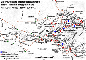
Sokhta Koh (also known as Sotka Koh) (Hindi:सोतका कोह) is the coastal Harappan site, meaning 'burnt hill', which was first surveyed by an American archaeologist George F Dales in 1960, while exploring estuaries along the Makran coast, Balochistan, Pakistan. It is a site of Indus Valley Civilization.
Location
The site is located about 15 miles north of Pasni. A similar site at Sutkagen-dor (also spelled Sutkagan Dor) lies about 30 miles inland, astride Dasht River, north of Jiwani. Their position along a coastline (that was possibly much farther inland) goes well with evidence of overseas commerce in Harappan times. Based on pottery styles, it is estimated that the settlement belongs to the Mature Harappan (Integration) Era (2600-1900 BC).
Abandonment and relocation
Sokhta Koh may have been abandoned due to recession of coast caused by one or more of following reasons:
- Gradual or catastrophic tectonic uplift
- Deposition of alluvial soil/silt in Shadi Kaur delta
- Deposition of sand on beach and in the estuary by wave action
Evidence of ruins of another location nearer to the sea, at the mouth of Shadi Kaur, seems to indicate possible relocation after the estuary harbour at Sokhta Koh had dried up due to coastal recession. Discovery of a harbour, as well as the source of firewood for large-scale pottery firing would be significant challenges for future excavations.
History
Alexander the Great is said to have stopped at Pasni (called 'Cysa' in Arrian's treatise Indica) while unsuccessfully trying to rendezvous with his admiral, Nearchus, during a disastrous exodus via Makran after the Indian Campaign (325 BC). According to one theory, Admiral Nearchus' well-stocked fleet was supposed to have continuously provisioned Alexander's army as the latter marched West along the barren coast towards Persia. In the event, a major portion of Alexander's route through Makran (Bela-Averan-Hoshab-Turbat and then south to Pasni-Gwadar) turned out to be much further inland than expected, apparently due to faulty knowledge of the terrain.
An unexplored Harappan-era settlement known as Sokhta Koh is tucked away in the low hills, about 25 km north of Pasni. It is conjectured that this was an ancient Harappan outpost which traded luxury wares with Mesopotamia and Persian Gulf settlements.
The town of Pasni, along with Gwadar, were burned by the Portuguese in 1581, having had some violent encounters with the Kalmatis in the area.[1]
The town was attacked again, by Baloch rebels during the 1898 Baloch uprising; the town was looted, and the telegraph lines running to Gwadar severed.[2]
References
Back to Indus Valley Civilization

