Aroli Nagpur
| Author:Laxman Burdak, IFS (R) |
- For other village of this name see Aroli


Aroli (आरोळी) is a village in Mauda tehsil in Nagpur district of Maharashtra.
Location
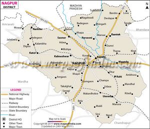
Aroli is a Village in Mouda Taluka in Nagpur District of Maharashtra State, India. It belongs to Vidarbh region . It belongs to Nagpur Division . It is located 49 KM towards East from District head quarters Nagpur, 11 KM from Mouda. Aroli Pin code is 441106 and postal head office is Ramtek. Tuman ( 5 KM ) , Indora ( 5 KM ) , Rajoli ( 6 KM ) , Kachurwahi ( 6 KM ) , Kharda ( 7 KM ) are the nearby Villages to Aroli. Aroli is surrounded by Ramtek Taluka towards North , Mohadi Taluka towards East , Parseoni Taluka towards west , Bhandara Taluka towards East . Ramtek , Kamthi , Bhandara, Tumsar are the near by Cities to Aroli. [1]
Origin
The Founders
Rivers
Rivers Near Aroli are:
- Pivli Nadi
- Nag River (नाग नदी)
History
- Akoli = Ankollika (अङ्कोल्लिक) (L.17). Ankollika (अङ्कोल्लिक) (L.17), mentioned in Nagardhan Plates Of Svamiraja : (Kalachuri) Year 322 (=573 AD), which was situated on the bank of the Shulanadi, has been identified by Vasudev Vishnu Mirashi with modern Aroli, on the right bank of the Shur River, about 8 miles south by east of Nagardhan.[2] Our view is that this village may be Akoli in Kuhi tehsil in Nagpur district of Maharashtra.
Jat Gotras
Population
Notable Persons
External Links
References
Back to Jat Villages

