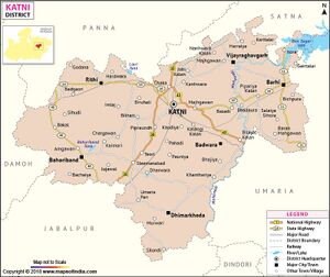
Bahoriband

Bahoriband (बहोरिबंद) is a town and tahsil of district Katni, Madhya Pradesh.
Variants
- Bahuriband/Bahuribanda (बहुरीबंद), म.प्र., (AS, p.615)
- Bahulaband (बहुलबंद)
- Tholabana (थोलावन) (Ptolemy)
Location
It is located 44 km towards west from District headquarters Katni.
History
The ancient Indians used the local geology to build numerous small dams to harvest rainwater into water reservoirs that locals call jhils. These reservoirs extend from Bahuriband to the north of Tigawa. The local tradition is that there was in the distant past a large city in that location, which would explain the numerous mounds found in their region and when excavated, these mounds have yielded broken pottery and bricks. Alexander Cunningham speculated in 1879 that the Bahuriband (also Bahulaband, about 4 kms south of Tigawa) may have been the city that Ptolemy transliterated as Tholabana.[1]
Local tradition believes that it once had a fort and it was part of a major town named Jhanjhangarh, a suburb of ancient Bahuriband.[2]
Inscription
Bahoriband is famous of the inscription [3] at the feet of a colossal stone image of Jain Tirthankara Shantinath. [4] The colossal statue is 12 feet and 2 inches in height.[5]
The inscription reads:
|
संवत १०..फल्गुन वदि ९ सोमे श्रीमद गयाकर्णदेव विजयराज्ये राष्ट्रकूटकुलोद्भव महासमन्ताधिपति श्रीमद् गोर्ल्हणदेवस्य प्रवर्धमानस्य || श्रीमद् गोल्लापूर्वाम्नाये वेल्लप्रभाटिकायामुरुकृताम्नाये तर्कतार्किक चूडामणि श्रीमन् माधवनन्दिनानुगृहीतः तस्साधु श्री सर्व्वधरः तस्य पुत्र महाभोज धर्म्मदानाध्ययनरतः तेनेदं कारितं रम्यम शान्तिनाथस्य मन्दिरं|| स्वलात्यम् सर्ज्जक सूत्रधारः श्रेश्ठि नमावितानं महाश्वेत.म निर्मितमतिसुन्दरं|| श्रीमच्चन्द्रकराचर्य्याम्नाय देशीगणान्वये समस्त विद्या विनयानन्दित विद्वज्जनाः प्रतिष्ठाचार्य श्रीमत् सुभद्राश्चिरं जयतु || |
| Bahoriband inscription Saka era 1020 to 1047 AD.[6] |
The Bahuriband stone inscription from the reign of Kalachuri Gayakarna[7] mentions that one Mahabhoja, son of Sadhu Sarvadhara, from the Golapurva community erected a temple of Shantinath. The image was consecrated by the Acharya Subhadra who belonged to the line of Desiya Gana (a branch of Mula Sangh) in the amnyaya of Candrakara Acharya. The region was ruled by Mahasamanta Golhana Deva of Rashtrakuta clan.
The samvat is not clearly read, Cunningham estimated it to be Saka era 1020 to 1047 AD.[8] Epigraphist Dr. Suman dates it to Vikram 1182 or 1125 CE.[9]
An edict of Ashoka is engraved at a spot named Rupanath nearby.
Monuments
बहुरीबन्द
विजयेन्द्र कुमार माथुर[10] ने लिखा है....बहुरीबन्द (AS, p.615) मध्य प्रदेश में जबलपुर से 42 मील की दूरी पर उत्तर में स्थित एक ग्राम है, जिसे कनिंघम ने टॉलमी द्वारा उल्लिखित 'थोलावन' माना है। इस गाँव में जैन तीर्थंकर शांतिनाथ की 13 फुट ऊँची, श्याम पाषाण की मूर्ति अवस्थित है, जिसे स्थानीय लोग 'खनुवादव' नाम से जानते हैं। मूर्ति के निम्न भाग में एक अभिलेख उत्कीर्ण है, जिससे सूचित होता है कि [p.616]: यह मूर्ति महासामंताधिपति गोल्हणदेव राठौड़ के समय में बनी थी और यह शासक कलचुरी नरेश रायकर्णदेव का सामंत था। लिपि से मूर्ति का समय 12वीं शती जान पड़ता है।
Notable persons
References
- ↑ Cunningham, Alexander (1879). Report of a Tour in the Central Province in 1873-74-75-76 (Vol IX). Archaeological Survey of India. New Delhi, pp. 39-43;
- ↑ Cunningham, Alexander (1879). Report of a Tour in the Central Province in 1873-74-75-76 (Vol IX). Archaeological Survey of India. New Delhi, pp. 39-43;
- ↑ Reports By India Archaeological Survey, Archaeological Survey of India, Published 1879, Office of the Superintendent of Government Printing p. 39-40
- ↑ Nand Chand and a Central Indian Regional Style, by Donald M. Stadtner, Artibus Asiae, 1981, 129-152
- ↑ Cunningham 1879, p. 40.
- ↑ Reports By India Archaeological Survey, Archaeological Survey of India, Published 1879, Office of the Superintendent of Government Printing p. 39-40
- ↑ The Kalachuris and Their Times By R. K. Sharma, Published 1980 Sundeep Prakashan
- ↑ Cunningham 1879, p. 41.
- ↑ Kasturchand Jain Suman, Bharatiya Digambar Jain Abhilekh aur Tirth Parichay, Madhya-Pradesh: 13 vi shati tak, Delhi, 2001.
- ↑ Aitihasik Sthanavali by Vijayendra Kumar Mathur, p.615-616

