Bemetara
| Author:Laxman Burdak, IFS (R) |


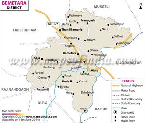
Bemetara (बेमेतरा) is a city and district (formed in 2012 after partition of Durg) of Indian state of Chhattisgarh. Author (Laxman Burdak) visited it on 16.04.1985 while on way from Raipur - Jabalpur.
Variants
Location
Geography
Bemetara is located near the centre of a large plain, sometimes referred as the "rice bowl of India", where hundreds of varieties of rice are grown. The Shivnath River flows to the east of the city of bemetara, and the southern side has dense forests. The Maikal Hills rise on the north-west of Bemetara; on the north, the land rises and merges with the Chota Nagpur Plateau, which extends north-east across Jharkhand state. On the south of Bemetara lies the Deccan Plateau.
Tahsils
Nawagarh, Bemetara, Saja, Than Khamharia, Berla
History
बेमेतरा
बेमेतरा को फौजी जिला के नाम से भी जाना जाता है बेमेतरा ज़िले को दुर्ग जिले से १४ जनवरी २०१२ को अलग करा गया। यह जिला मूल रूप से अपने उन्हारी उत्पादन के लिए पुरे एशिया में विख्यात हैं। यहाँ चना का अत्यधिक उत्पादन होता है। शिक्षा के क्षेत्र में भी यह जिला अग्रिणी रहा हैं। अंतर्राष्ट्रीय स्तर के कवि सुरेन्द्र दुबे भी इसी माटी के हैं, इन्टरनेट पर न्यूज़ सर्विस दे रहे अजीत कुमार शर्मा बेमेतरा जिले के पहले अधिमान्य प्राप्त पत्रकार हैं। माता भद्रकाली संस्थान, योगिद्वीप. देवरबीजा, सरदा, देवकर. नवागढ़ सहित कई महत्वपूर्ण जगह इस किले में स्थित हैं।बेमेतरा से लगभग 14 किलोमीटर की दूरी पर ग्राम संडी है जहाँ पर माँ सिद्धि विराज मान है जिसके दर्शन मात्र से मनोकामनाएँ पूर्ण होती है।रेलमार्ग से अछूता यह शहर सिर्फ सड़क मार्ग के भरोसे भी सफलता की और अग्रसर हैं।
References
Back to Chhattisgarh

