Chabahar
| Author:Laxman Burdak, IFS (Retd.) |


Chābahār (Hindi: चाबहार , Persian: چابهار ) is a city in and capital of Chah Bahar County, Sistan and Baluchestan Province, Iran. Formerly it was called Bandar Beheshtī. Chabahar is a free port (Free Trade Zone) on the coast of the Gulf of Oman.
Location
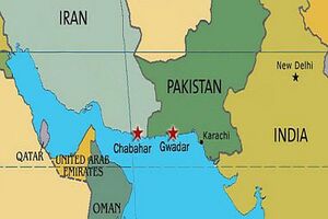
Chabahar is Iran's southernmost city. Chabahar is situated on the Makran Coast of the Sistan and Baluchestan province of Iran.
Origin of name
The name bases on Persian Char that means four and Bahar that means Spring. Hence, it means a place that all four seasons of the year are Spring time.
Jat clans
People
The overwhelming majority of the city's inhabitants are ethnic Baluch who speak the Baluchi language. Society and culture in Chabahar gained its characteristics from the classified tribal community of the Makran region. In this classification, Chabahar society is divided into superior and inferior tribes. Social structure is hierarchical; at the top of the pyramid are superior tribes locally dubbed as Hakom, independent influential tribes are in the middle, and other inferior weak tribes are at the bottom of the pyramid. Hakomes are Khans or Sardars, which in Chabahar refers to Sardarzahi and Boledehi tribes. Hoot and Mir (jadgals) are examples of independent, influential tribes which are at the next higher level in the hierarchy. There are many tribes in the upper and lower middle level, but at the bottom are former slaves from eastern Africa that have been brought by colonialists and Arab traders, especially Omanis, to the Makran Coastal area. These tribes are known as Darzada, Nokar, Sheedi and Gholams. The dominant culture in Chabahar is similar to other parts of Makran.
History
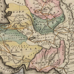
Chabahar is shown as Carpella port on the Map showing the route of Alexander the Great.
There is a fishing village and former port named Tis in Chabahar's neighborhood, which dates from 2500 BC, known in Alexander the Great's conquests as Tiz, eventually renamed Tis.
In addition, in his book Aqd al-Ala lel-Moghefe al Ahla, Afdhal al-Din abu Hamid Kermani wrote in 584 A.H. (1188) about the port of Tiz and its commerce and trade. According to the scholar and historian, Alberuni, author of an encyclopedic work on India called "Tarikh Al-Hind", the sea coast of India commences with Tiz or modern Chabahar.[1]
As a matter of fact the Sarhad range which runs from north to south and separates the Sub-continent of India from the Plateau of Iran, commences in the vicinity of Tiz. Tis was formerly an active commercial port, and was destroyed by the Mongols. There are still some ruins in the village. The Portuguese were the first colonial country to attack the Makran (Oman) Sea. The Portuguese forces under Afonso de Albuquerque gained control of Chabahar and Tis, staying there until 1031 A.H. (1621). The British, and later the Portuguese in the 17th century (year 1616) AC (1026 A.H.), entered this region.
Economic significance
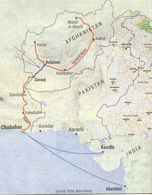
Chabahar is Iran's closest and best access point to the Indian Ocean. For this reason, Chabahar is the focal point of Iranian development of the east of the country through expansion and enhancement of transit routes among countries situated in the northern part of the Indian Ocean and Central Asia. The hope is that with the development of transit routes, and better security and transit services, the benefits will reach the local residents. Chabahar's economic sectors are fish industries and commercial sector, fishery sectors with the largest amount of country's fish catch, mainly located out of the Chabahar Free Trade-Industrial Zone. Growing commercial sector located at free trade area with high potentiality to turn to a place that would connect business growth centers in south Asia (India) and Middle East (Dubai) to Central Asian and Afghanistan market. The government plans to link the Chabahar free trade area to Iran's main rail network, which is connected to Central Asia and Afghanistan as well.
References
- ↑ Alberuni's India: An Account of the Religion, Philosophy, Literature, Geography, Chronology, Astronomy, Customs, Laws and Astrology of India about A.D. 1030, by Edward C. Sachau Published by Kegan Paul, Trench, Trübner & Co., 1910
Back to Jat Places in Iran

