Chincholi
| Author:Laxman Burdak, IFS (R) |


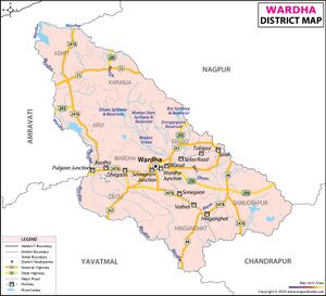
Chincholi is an ancient historical village in Samudrapur tahsil in Wardha district of Maharashtra. It has been mentioned as Chinchapalli (चिंचापल्ली) in Jamb Plates of 2nd year of Pravarasena II[1]
Variants
- Chinchapalli (चिंचापल्ली) in Jamb Plates of 2nd year of Pravarasena II
Origin
Location
Jat Gotras Namesake
History
Jamb Plates Of 2nd year of Pravarasena II[2] record the grant, by Pravarasena II, of the village Kothuraka which was situated in the āhāra (territorial division) of Supratishtha (सुप्रतिष्ठाहार). The village lay to the west of the river Uma, to the north of Chinchapalli (चिंचापल्ली), to the east of Bonthikavataka (बोन्थिकवाटक) and to the south of Mandukigrama (मण्डूकिग्राम). The donee was the celibate Brahmana Kaluttaka (कालूट्टक), who belonged to the Kaundinya gotra and the Taittiriya shakha of the Black Yajurveda. The grant was made at the victorious place of religious worship (vaijayika dharmasthana) and is dated on the twelfth tithi of the bright fortnight of Asvina in the second regnal year. The Dutaka was Chakradeva, and the scribe Nagavarman. (p.11)
Nandivardhana (नन्दिवर्द्धन) has already been identified with Nandardhan or Nagardhan near Ramtek in the Nagpur District.
Kothurarka (कोथुरक), the donated village, cannot now be traced. Its site seems to have been occupied by Mangaon (माणगाँव) on the right bank of the Wunna, about 2-1/2 miles north by west of Jamb, since all the boundary villages mentioned in the present plates can be identified in its vicinity in their respective directions. Thus
Chinchapalli (चिंचापल्ली) is Chicholi which also is situated on the right bank of the same river Wunna, half a mile to the south of Mangaon (माणगाँव);
Bonthikavataka (बोन्थिकवाटक) is now called Bothad (बोथड़) and
Mandukigrama (मण्डूकिग्राम), Mandgaon (माण्डगाँव), about 3-1/2 miles to the north by west and 2 miles to the north respectively from Mandgaon. The Wardha District Gazetteer records a tradition that Mandgaon is named after one Mando Rishi who is said to have done penance on the Wunna river. The present grant, however, shows that the ancient name of the place (p.11) was Mandukigrama. The identification of these three boundaries shows that the river Uma which formed the eastern boundary of the donated village is none other than the Wunna. (p.12)
Notable persons
Gallery
External links
References
- ↑ Corpus Inscriptionum Indicarum Vol.5 (inscriptions Of The Vakatakas), Edited by Vasudev Vishnu Mirashi, 1963, Archaeological Survey of India, p.10-15
- ↑ Corpus Inscriptionum Indicarum Vol.5 (inscriptions Of The Vakatakas), Edited by Vasudev Vishnu Mirashi, 1963, Archaeological Survey of India, p.10-15

