Red Sea
| Author:Laxman Burdak, IFS (R) |


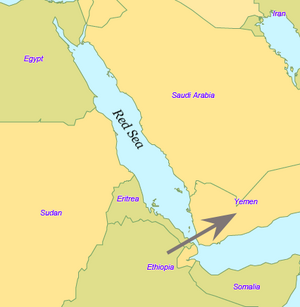
Red Sea (लालसागर), or the Erythraean Sea, is a seawater inlet of the Indian Ocean, lying between Africa and Asia. The connection to the ocean is in the south through the Bab el Mandeb strait and the Gulf of Aden. The sea is underlain by the Red Sea Rift which is part of the Great Rift Valley.
Variants
- Red Sea (Anabasis by Arrian, p. 155, 161, 309, 400.)
- Erythraean Sea
- लालसागर
- Red Sea (रेड सी)
Origin of name
The name of the sea may signify the seasonal blooms of the red-coloured Trichodesmium erythraeum near the water's surface. [1]
Location
In the north, there is the Sinai Peninsula, the Gulf of Aqaba, and the Gulf of Suez (leading to the Suez Canal).
History
The earliest known exploration of the Red Sea was conducted by ancient Egyptians, as they attempted to establish commercial routes to Punt. One such expedition took place around 2500 BC, and another around 1500 BC (by Hatshepsut). Both involved long voyages down the Red Sea.[2] The Biblical Book of Exodus tells the story of the Israelites' crossing of a body of water, which the Hebrew text calls Yam Suph. Yam Suph was traditionally identified as the Red Sea. The account is part of the Israelites' escape from slavery in Egypt. Yam Suph can also been translated as Sea of Reeds.
In the 6th century BC, Darius the Great of Persia sent reconnaissance missions to the Red Sea, improving and extending navigation by locating many hazardous rocks and currents. A canal was built between the Nile and the northern end of the Red Sea at Suez.
In the late 4th century BC, Alexander the Great sent Greek naval expeditions down the Red Sea to the Indian Ocean. Greek navigators continued to explore and compile data on the Red Sea. Agatharchides collected information about the sea in the 2nd century BC.
The Periplus of the Erythraean Sea ("Periplus of the Red Sea"), a Greek periplus written by an unknown author around the 1st century AD, contain a detailed description of the Red Sea's ports and sea routes.[3] The Periplus also describes how Hippalus first discovered the direct route from the Red Sea to India.
The Red Sea was favored for Roman trade with India starting with the reign of Augustus, when the Roman Empire gained control over the Mediterranean, Egypt, and the northern Red Sea. The route had been used by previous states but grew in the volume of traffic under the Romans. From Indian ports goods from China were introduced to the Roman world. Contact between Rome and China depended on the Red Sea, but the route was broken by the Aksumite Empire around the 3rd century A D.[4]
During the Middle Ages, the Red Sea was an important part of the Spice trade route. In 1513, trying to secure that channel to Portugal, Afonso de Albuquerque laid siege to Aden.[5] but was forced to retreat. They cruised the Red Sea inside the Bab al-Mandab, as the first European fleet to have sailed these waters.
अग्निमाली
विजयेन्द्र कुमार माथुर[6] ने लेख किया है ...अग्निमाली (AS, p.10) शूर्पारक-जातक में वर्णित एक सागर-'यथा अग्गीव सुरियो व समुद्दोपति दिस्सति, सुप्पारकं तं पुच्छाम समुद्दो कतमो अयंति। भरुकच्छापयातानं वणि-जानं धनेसिनं, नावाय विप्पनट्ठाय अग्गिमालीति वुच्चतीति।'
अर्थात् जिस तरह अग्नि या सूर्य दिखाई देता है वैसा ही यह समुद्र है; शूर्पारक, हम तुमसे पूछते हैं कि यह कौन-सा समुद्र है? भरुकच्छ से जहाज़ पर निकले हुए धनार्थी वणिकों को विदित हो कि यह अग्निमाली नामक समुद्र है।
इस प्रसंग के वर्णन से यह भी सूचित होता है कि उस समय के नाविकों के विचार में इस समुद्र से स्वर्ण की उत्पत्ति होती थी। अग्निमाली समुद्र कौन-सा था, यह कहना कठिन है। डॉ. मोतीचंद के अनुसार यह लालसागर या रेड सी का ही नाम है किंतु वास्तव में शूर्पारक-जातक का यह प्रसंग जिसमें क्षुरमाली, नलमाली, दधिमाली आदि अन्य समुद्रों के इसी प्रकार के वर्णन हैं, बहुत कुछ काल्पनिक तथा पूर्व-बुद्धकाल में देश-देशांतर घूमने वाले नाविकों की रोमांस-कथाओं पर आधारित प्रतीत होता है। भरुकच्छ या भडौंच से चल कर नाविक लोग चार मास तक समुद्र पर घूमने के पश्चात् इन समुद्रों तक पहुंचे थे। (दे. क्षुरमाली, बड़वामुख, दधिमाली, नलमाली, कुशमाल)
Gallery
-
Map of Middle East Countries]]
References
- ↑ "Red Sea". Encyclopædia Britannica Online Library Edition. Encyclopædia Britannica.
- ↑ Fernandez-Armesto, Felipe (2006). Pathfinders: A Global History of Exploration. W.W. Norton & Company. p. 24. ISBN 0-393-06259-7.
- ↑ Fernandez-Armesto, Felipe (2006). Pathfinders: A Global History of Exploration. W.W. Norton & Company. pp. 32–33. ISBN 0-393-06259-7.
- ↑ East, W. Gordon (1965). The Geography behind History. W.W. Norton & Company. pp. 174–175. ISBN 0-393-00419-8.
- ↑ By M. D. D. Newitt, "A history of Portuguese overseas expansion, 1400-1668", p.87, Routledge, 2005, ISBN 0-415-23979-6
- ↑ Aitihasik Sthanavali by Vijayendra Kumar Mathur, p.10


![Map of Middle East Countries]]](/w/thumb.php?f=Middle_East_Countries_Map.jpg&width=120)