Farrukhabad

Farrukhabad (फ़र्रूख़ाबाद) is a city and District in Uttar Pradesh in northern India.
Variant
- Farukhabad फरुखाबाद, उ.प्र., (AS, p.597)
Location
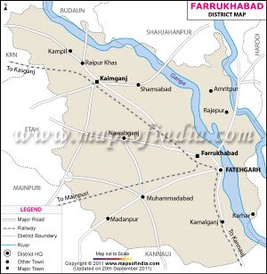
Farrukhabad is situated between Lat. 26° 46' N & 27° 43' N and Long. 79° 7' E & 80° 2' E. The district is bounded by Badaun and Shahjahanpur on the north, Hardoi District on the east, Kannauj District on the south, and Etah and Mainpuri districts on the west. The Ganges River and Ramganga River are located to the east and the Kali River to the south. The city is on the banks of river Ganges and is 338 kms from the national capital Delhi and 190 kms from the state capital Lucknow.
Jat Gotras
- Dahiya (दहिया)
History
फरुखाबाद
विजयेन्द्र कुमार माथुर[1] ने लेख किया है .....फरुखाबाद (AS, p.597), उ.प्र., : इस नगर को नवाब मुहम्मदशाह बंगस ने मुगल सम्राट फर्रूखसियर (1712-1719 ई.) के नाम पर बसाया था. इसी इलाके (जो प्राचीन काल में दक्षिण पंचाल कहलाता था) की राजधानी पहले कन्नौज थी. इस नगर के बस जाने पर राजधानी यहीं बनाई गई और कालपी के बंगश शासकों ने अपने प्रांत का मुख्य स्थान इसी नगर को बनाया.
Administrative divisions
The district formerly included present day Kannauj district. It was divided into two separate districts on 18 September 1997.
Farrukhabad district consists of three tahsils: Farrukhabad, Kaimganj and Amritpur.
The district has seven blocks: Kaimganj, Nawabganj, Shamsabad, Rajepur, Barhpur, Mohamadabad and Kamalganj.
Places of Historical importance
Notable persons
- Pahalwan Prem Singh Dahiya Social Woker and Zamindar
- Vijay Singh Dahiya MLA 2002, 2007, 2012
- Damyanti Vijay Dahiya w/o Vijay Singh - Municipality President Farrukhabad
- Hem Singh
- Ekta Dahiya - Politician
- Karan Singh Dahiya - Politician
Author
Source - Ranvir Singh from Gwalior via WhatsApp Mob.94251 37463
References
Back to Uttar Pradesh

