Gadchiroli
| Author:Laxman Burdak, IFS (R) |


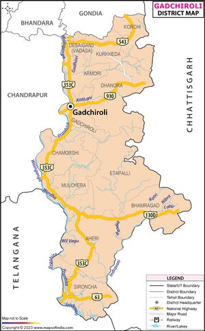
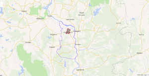
Gadchiroli (गढ़चिरौली) is a city and district in Maharashtra, India. Gadchiroli District was created on 26 August 1982 by the separation of Gadchiroli and Sironcha talukas from Chandrapur district.
Variants
- Garhchiroli (गढ़चिरौली)
Location
Maharashtra tapers in the east, where this district forms the south-east corner. The district is bordered by Gondia district to the north, Mohla-Manpur-Ambagarh Chowki, Kanker, Narayanpur and Bijapur districts of Chhattisgarh to the east, Jayashankar Bhupalpally district of Telangana to the south, and Mancherial and Komaram Bheem districts of Telangana and Chandrapur district to the west.
Divisions
The district is divided into six revenue sub-divisions: 1. Gadchiroli, 2. Aheri,3. Chamorshi, 4. Etapalli, 5. Wadsa (Desaiganj), 6. Kurkheda. These are each further divided into 2 taluka. Gadchiroli sub-division consists of Gadchiroli and Dhanora, Chamorshi sub-division consist of chamorshi and Mulchera talukas; Aheri sub-division consists of Aheri and Sironcha. Etapalli sub-division cover Etapalli and Bhamragad talukas; and Desaiganj (Wadsa) sub-division consists of Wadsa and Armori. Kurkheda sub-division consist of Kurkheda and Korchi talukas. There are 557 gram panchayats (village councils) and 1,688 Revenue Villages. The district has 12 panchayat samitis (local development-block governments). Only three municipalities, Gadchiroli, Wadsa (Desaiganj), and Armori exist in the district.
Geography
Established on 26 August 1982 The main river basin of the district is the Godavari, which flows west-to-east and forms the southern boundary of the district. The major tributaries of the Godavari are the Indravati and the Pranhita, the latter of which is formed by the confluence of the Wainganga and the Wardha near Chaprala village of Chamorshi taluka.
Dhanora, Etapalli, Aheri and Sironcha talukas in the eastern part of the district are covered by forest. Hills are found in Bhamragad, Tipagad, Palasgad and Surjagad area. The eastern part of Gadchiroli, bordering Chhattisgarh state, is mainly hilly and is tribal-dominated, similar to neighbouring Bastar region in Chhattisgarh.
गढ़चिरौली
गढ़चिरौली ज़िला भारत के महाराष्ट्र राज्य का एक ज़िला है। ज़िले का मुख्यालय गढ़चिरौली है। गढ़चिरौली जिले का गठन 26 अगस्त 1982 को चंद्रपुर जिले से गढ़चिरौली और सिरोंचा तहसीलों को अलग करके किया गया था। गढ़चिरौली जिला महाराष्ट्र के दक्षिणपूर्वी कोने में स्थित है। यह पश्चिम में चंद्रपुर जिला, उत्तर में गोंदिया जिला, पूर्व में छत्तीसगढ़ राज्य और दक्षिण और दक्षिण पश्चिम में तेलंगाना राज्य से घिरा है। गढ़चिरौली आदिवासी ज़िला है। गोंड और माडिया समुदाय के लोग है। और एक खास बात यह बंगाली समुदाय के लोक भी ये जो की शरणार्थी है। 1972 के बांगला विभाजन के समय इस ज़िले मे बसाये गये।

