Kali Ganga
| Author:Laxman Burdak, IFS (R) |


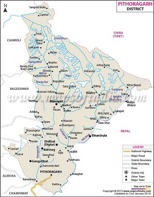
Kali Ganga (काली गंगा) or Sharda River (शारदा नदी), also called Kali River and Mahakali River, originates at Kalapani in Pithoragarh district of Uttarakhand, India.
Variants
- Sharada River शारदा, उ.प्र., (AS, p.895)
- Mahakali River (महाकाली नदी) (in Nepali)
- Sharada Nadi (शारदा नदी)
- Kali Gad (Hindi: काली गाड़, kālī gād) or Kali Ganga in Uttarakhand.
Jat clans
Course
It flows along Nepal's western border with India. It joins Ghaghra River, a tributary of the Ganges.[1] It takes the name Kali River from the union of the two streams at Gunji as it flows through the hills. After Brahmadev Mandi near Tanakpur, it enters the Terai plains, where it is called Sharda River.[2]
In the British definition of 1911, the Kali River is formed by the union of two headwaters: the Kalapani River that originates below the Lipulekh Pass and the Kuthi Yankti river that rises below the Limpiyadhura range.[3] But both the streams have been termed "Kali River" on different occasions.
The Kali River serves as the boundary between Uttarakhand (Kumaon region) and Nepal from "a little below the Kalapani encamping ground" (30.217°N 80.904°E).[4] The Lipulekh pass as well as the Limpayadhura pass (or Limpiya pass) are on Uttarakhand's border with Tibet.[5]
History
शारदा नदी
शारदा नदी (AS, p.895): यह नदी नंदादेवी पर्वत से निकलकर फैजाबाद के नीचे सरयू में मिल जाती है.[6]
काली गंगा या शारदा नदी परिचय
शारदा नदी का उदगम स्थान उत्तराखंड के पूर्वोत्तर कुमाऊँ क्षेत्र का मिलाम हिमनद और गण्डक महान् हिमालय है जो यहाँ से निकलती हुई उत्तर प्रदेश में बहती है। इसे प्रारम्भ में काली गंगा के नाम से पुकारा जाता है। उदगम के निकट इसकी दो सहायक नदियाँ हैं। उदगम के बाद लगभग 160 किलोमीटर प्रवाहित होने के पश्चात् पंचेश्वर के निकट इसमें सरयू और पूर्वी रामगंगा आकर मिलती हैं। यहीं से यह नदी सरयू या शारदा के नाम से पहाड़ियों में चक्करदार मार्ग से होकर ब्रह्मदेव के निकट मैदानी भाग में प्रवेश करती है। यहाँ यह कई भागों में बँट जाती है। परन्तु आगे चलकर मुढ़िया के निकट से सभी प्रवाह मार्ग पुनः एक हो जाते हैं। बहरामघाट के निकट पहुँचकर यह करनाली तथा घाघरा नदी में मिल जाती है।[7]
External links
References
- ↑ Midha, N. & Mathur, P.K. (2014). "Channel characteristics and planform dynamics in the Indian Terai, Sharda River" (PDF). Environmental management. 53 (1): 120–134
- ↑ Walton, H. G., ed. (1911). "Chapter I. General". Almora: A Gazetteer. District Gazetteers of the United Provinces of Agra and Oudh. 35. Allahabad: Government Press, United Provinces. p. 1–42.
- ↑ Walton, H. G., ed. (1911). "Chapter I. General". Almora: A Gazetteer. District Gazetteers of the United Provinces of Agra and Oudh. 35. Allahabad: Government Press, United Provinces. p. 1–42.
- ↑ Walton, Almora Gazetteer (1911), pp. 253–254.
- ↑ Himalayas, The Imperial Gazetteer of India, Volume 13, 1908, p.134.
- ↑ Aitihasik Sthanavali by Vijayendra Kumar Mathur, p.895
- ↑ भारतकोश-शारदा नदी

