
Kargil
| Author:Laxman Burdak, IFS (R) |


Kargil (कारगिल) is a city and a district of the union territory of Ladakh in India. It is the second-largest city in Ladakh after Leh.[1]
Location
Kargil is located 204 kilometres to the east of Srinagar in Jammu and Kashmir, and 234 kilometres to the west of Leh. It is the centre point of the Suru River.
Etymology
The name Kargil is said to derive from the words Khar, meaning castle, and rKil meaning "centre". "Kargil denotes a place between many forts, a central place where people could stay". It appears to be a fitting description for a place that is equidistant from Srinagar, Leh and Skardu.[2]
Administration
The Kargil district was formed in July 1979, by separating it from Leh. Kargil has five (5) Sub-Divisions, eight tehsils.
It is divided into five (5) Sub-Divisions: Drass, Kargil, Shakar-Chiktan, Sankoo, and Zanskar.[3]
Another form of division in terms of tehsils, of which there are eight: Drass, Kargil, Shargole, Shakar-Chiktan, Sankoo, TSG, (Trespone, Saliskote, Gund Mangalpore) Taisuru, Zanskar,[4]
History
Historically, the region around Kargil was called Purig. [5]A major study of the history of Purig is included in the 1987 book Qadeem Ladakh by Kacho Sikander Khan, which includes genealogies of various dynasties that ruled the region.[6]
Kargil is the main town in the historical region of Purig, which consists of the Suru river basin. It was not the historical capital of the region. Earlier, Purig consisted of a number of small but independent kingdoms, which included Pashkum, Chiktan, Fokar, Soth and the Suru Valley. Gasho "Thatha Khan", an exiled prince in the AD 9th century, is perhaps the first ruler who brought together all the territories under a united administration. Another sultan of Purig extended his kingdom to include Zanskar, Sot, Barso, Sankoo pretty much the territory of the present Kargil district. He is referred to as "The Purig Sultan". His capital was based at Karpokhar in the Suru Valley. The other famous kings of Kargil were Boti Khan, Abdal Khan, Amrood Choo, Tsering Malik, Kunchok Sherab Stan and Thi Sultan.
It is said that it was the period of Ali Sher Khan Anchan, the famous ruler of Skardu, in the late 16th and early 17th centuries which had a great influence on the area. This prince from Baltistan conquered most of the principalities of Purig and introduced Balti culture in the Kargil district. Subsequently, it was the Dogras who united Baltistan, Purig, Zanskar and present-day Leh district in the first half of the 19th century under a single administrative unit, which lasted until 1947 when a new line of control was demarcated between India and Pakistan separating Skardu and Kargil.[7]
Before the Partition of India in 1947, Kargil was part of the wazarat (district) of Ladakh, a sparsely populated region with diverse linguistic, ethnic and religious groups, living in isolated valleys separated by some of the world's highest mountains. The Ladakh wazarat had three tehsils (sub-districts), named after the cities of their headquarters: Leh, Skardu and Kargil. The district headquarters shifted between the three locations each year.[8]
The First Kashmir War (1947–48) concluded with a ceasefire line that divided the Ladakh wazarat, putting roughly the Kargil and Leh tehsils on the Indian side, and the Skardu tehsil on the Pakistan side. The two Indian tehsils were soon promoted to districts and Ladakh was named a Division, on par with the Jammu and Kashmir Divisions in the Indian state of Jammu and Kashmir. Pakistan renamed the Skardu tehsil Baltistan and divided it into further districts.
At the end of Indo-Pakistani War of 1971, the two nations signed the Simla Agreement, converting the former ceasefire line with some adjustments into a Line of Control, and promising not to engage in armed conflict with respect to that boundary.[9]
In 1999 the area saw infiltration by Pakistani forces, leading to the Kargil War. Fighting occurred along a 160 km long stretch of ridges overlooking the only road linking Srinagar and Leh.[10] The military outposts on the ridges above the highway were generally around 5,000 metres (16,000 ft) high, with a few as high as 5,485 metres (18,000 ft). After several months of fighting and diplomatic activity, the Pakistani forces were forced to withdraw to their side of the Line of Control by their Prime minister Nawaz Sharif after his visit to the USA.[11]
Kargil-Skardu Road
A famous all-weather road, the Kargil-Skardu road linked Kargil with Skardu, a city in Gilgit-Baltistan. Since the 1948 Kashmir War, the road has been closed. Whilst the Indian Government has been interested in opening the road as a humanitarian gesture, this has been refused by the Pakistani Government."Moving on the Kargil-Skardu road". The Indian Express. 24 April 2007.
Jat clans
Jat History
कारगिल
कारगिल भारत के लद्दाख़ केन्द्रशासित प्रदेश के करगिल ज़िले में स्थित एक नगर है। यह ज़िले का मुख्यालय भी है। यह सुरु नदी की घाटी के मध्य में बसा हुआ है। कारगिल लद्दाख़ का एक प्रमुख पर्यटन स्थल है। वैसे यह स्थान मुख्य से बौद्ध पर्यटन केंद्र के रूप में प्रसिद्ध है। यहां बौद्धों के कई प्रसिद्ध मठ स्थित है। मठों के अतिरिक्त यहां कई अन्य चीजें भी घूमने लायक है। यहाँ की प्राकृतिक सुंदरता पर्यटकों को अपनी ओर आकर्षित करती है। ट्रैकिंग का शौक़ रखने वालों के लिए भी आकर्षण का केंद्र है। कारगिल जिला कश्मीर घाटी के उत्तर-पूर्व पर स्थित है। यह स्थान श्रीनगर से 205 किलोमीटर की दूरी पर स्थित है। कारगिल 1999 में पाकिस्तान के साथ हुए युद्ध से चर्चा में आया था।
कारगिल के मुख्य आकर्षण
मुलबेख गोम्पा: मुलबेख गोम्पा एक मठ है। यह मठ कारगिल ज़िले के मुलबेख में स्थित है। मुलबेख कारगिल से लगभग 45 किलोमीटर और लेह से 190 किलोमीटर की दूरी पर है। मठ तक पहुँचने के लिए खडी चट्टान और घाटी से होकर गुज़रना पड़ता है। यह मठ समुद्र तल से 200 मीटर की ऊँचाई पर स्थित है। यहाँ स्थित भित्तिचित्र, मूर्तियाँ और स्मृतिचिन्ह इस मठ की शोभा को और अधिक बढ़ाते हैं। मुलबेख गोम्पा से आस-पास की ख़ूबसूरत घाटियों का नज़ारा देखा जा सकता है।
शरगोल मठ: शरगोल मठ कारगिल ज़िले से दस किलोमीटर की दूरी पर स्थित मुलबेस में है। इस पुरानी गी-लुग पा बौद्ध मठ में कई बेहतरीन भित्तिचित्र देखे जा सकते हैं। मठ के एक मंदिर है जिसमें अवलिकेतेश्वर की ग्यारह हाथों वाली प्रतिमा स्थित है। इसके अलावा लकड़ी से बनी देवी तारा की प्रतिमा है। इस ख़ूबसूरत प्रतिमा को तिब्बितयन कलाकारों ने बनाया था।
स्टोंगदे मठ: स्टोंगदे मठ पदुम के समीप स्टोंगदे में स्थित है। स्टोंगदे दूसरा बड़ा मठ है। यह काफ़ी पुराना मठ है। इस मठ की नींव तिब्बतन योगी मारपा ने रखी थी। इस मठ में काफ़ी संख्या में मंदिर बने हुए है। यह मठ पदुम से अठारह किलोमीटर की दूरी पर स्थित है।
नुन-कुन गिरीपिण्ड: नुन-कुम मासिफ विशाल हिमालय पंक्ति है। यह लद्दाख़ का सबसे ऊँचा शिखर है। समुद्र तल से इसकी ऊँचाई लगभग 7,077 मीटर है। कारगिल के दक्षिण से इस जगह की दूरी 70 किलोमीटर है। इस गिरीपिण्ड में दो प्रमुख पर्वत जिसमें पहला नुन (7,357 मीटर) और दूसरा कुन (7,087 मीटर) है। इस पर्वतों पर सुरू घाटी द्वारा पहुँचा जा सकता है।
कनिक स्तूप: कनिक स्तूप कारगिल ज़िले के सनी पर स्थित है। इस स्तूप का सम्बन्ध प्रसिद्ध भारतीय योगी नारूपा से है। ऐसा माना जाता है कि इन संत ने इस स्तूप के भीतर रहकर कुछ समय तक ध्यानसाधना की थी। यहाँ एक छोटा सा कमरा है जिसमें योगी की कंसे की मूर्ति स्थापित है। इस आकृति को वर्ष में केवल एक बार जुलाई माह के अंत में देखा जा सकता है। इस अवसर के दौरान एक त्यौहार मनाया जाता है। यह त्यौहार दो दिनों तक चलता है। काफ़ी संख्या में लोग इस अवसर पर सम्मिलित होते हैं। इसके अलावा, बरदान मठ के मठवासियों द्वारा नकाब नृत्य प्रस्तुत किया जाता है।
See also
Gallery
-
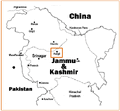
Location of Kargil with respect to the Line of Control
-
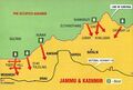
Map of Kargil War areas
-
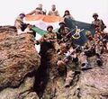
Indian soldiers after winning a battle during the Kargil War
-
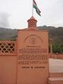
Kargil War Memorial


External links
References
- ↑ Osada et al (2000), p. 298.
- ↑ Gupta, Radhika (2013). "Allegiance and Alienation: Border Dynamics in Kargil". In David N. Gellner (ed.). Borderland Lives in Northern South Asia. Duke University Press. p. 49. ISBN 978-0-8223-7730-6.
- ↑ https://kargil.nic.in/tehsil/
- ↑ https://kargil.nic.in/tehsil/
- ↑ Grist, Nicola (2008). "Urbanisation in Kargil and its Effects in the Suru Valley". In Martijn van Beek; Fernanda Pirie (eds.). Modern Ladakh: Anthropological Perspectives on Continuity and Change. BRILL. p. 80. ISBN 978-90-474-4334-6.
- ↑ Kalla, Krishan Lal (1997). Kashmir Panorama. Raj Publications. ISBN 978-81-86208-07-6.
- ↑ Ismail Khan (4 September 2005). "A peaceful Kargil". Dawn.
- ↑ Aggarwal, Ravina (2004), Beyond Lines of Control: Performance and Politics on the Disputed Borders of Ladakh, India, Duke University Press, ISBN 0-8223-3414-3, p.35.
- ↑ Cheema, Pervaiz Iqbal (2003). The Armed Forces of Pakistan. Allen & Unwin. ISBN 1-86508-119-1. Pg 4
- ↑ "1999 Kargil Conflict". GlobalSecurity.org.
- ↑ "War in Kargil – The CCC's summary on the war" (PDF).