Comilla
| Author:Laxman Burdak, IFS (R) |


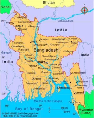
Comilla (कोमिल्ला) is a city in the Chittagong Division of Bangladesh. Comilla is the second-largest city of eastern Bangladesh after Chittagong and is one of the three oldest cities in Bangladesh.
Variants
Location
It is located along the Dhaka-Chittagong Highway. Comilla covers a total area of 51 square kms. It is bounded by Burchiganj and Tripura on the north, Laksham and Chauddagram on the south, and Barura on the west. The major rivers that pass through Comilla include Gumti[1] and Little Feni. The Tropic of Cancer crosses Comilla town on the south side just over the Tomsom Bridge.
History
Established as the Tippera or Tipperah district of Bengal by the British in 1790,[2] it included the Sub-divisions of Brahmanbaria and Chandpur which eventually became separate districts in 1984.The district was renamed Comilla in 1960. Comilla district is located in the south eastern part of Bangladesh.[3]
The Comilla region was once under ancient Samatata and was joined with Tripura State. This district came under the reign of the kings of the Harikela in the ninth century AD. Lalmai Mainamati was ruled by the Deva dynasty (eighth century AD), and (during 10th and mid-11th century AD). In 1732, it became the centre of the Bengal-backed domain of Jagat Manikya.[4]
The Peasants’ Movement against the king of Tripura in 1764, which originally formed under the leadership of Shamsher Gazi is a notable historical event in Comilla.[5] It came under the rule of East India Company in 1765. This district was established as Tripura district in 1790. It was renamed Comilla in 1960. Chandpur and Brahmanbaria subdivisions of this district were transformed into districts in 1984.
कोमला
विजयेन्द्र कुमार माथुर[6] ने लेख किया है ...कोमला (AS, p.236) वायु पुराण 2,37,369 में वर्णित नगर संभवत वर्तमान कोमिल्ला (बांगलादेश) छठी सदी ई. में यहां टिपारा प्रदेश की राजधानी थी. यह युवानच्वांग का कियामोलोंगकिया है. इसका एक अन्य नाम कमलांक भी है.
कर्मांत
विजयेन्द्र कुमार माथुर[7] ने लेख किया है ...कर्मांत = बड़कंत (जिला कोमिल्ला, बांग्लादेश) (AS, p.146): कर्मांत गुप्तकाल में संभवत: समतट प्रदेश की राजधानी कर्मांत (वर्तमान बड़कंत) नामक नगर में थी। समतट का उल्लेख समुद्रगुप्त की प्रयाग प्रशस्ति में है।
External links
References
- ↑ Chisholm, Hugh, ed. (1911). "Comilla" . Encyclopædia Britannica. 6 (11th ed.). Cambridge University Press. p. 763.
- ↑ "Gazetteer - Bengal District Gazetteer Tipperah District - South Asia Archive". www.southasiaarchive.com.
- ↑ Siddiqi, Mamun (2012). "Comilla District". In Islam, Sirajul; Jamal, Ahmed A. Banglapedia: National Encyclopedia of Bangladesh (Second ed.). Asiatic Society of Bangladesh.
- ↑ Kilikhar, Bidhas Kanti (1995). Tripura of the 18th Century with Samsher Gazi Against Feudalism: A Historical Study. Agartula: Chhapa Kathi, Tripura State Tribal Cultural Research Institute and Museum. p. 55. OCLC 39290375.
- ↑ Nawaz, Ali (2012). "Shamsher Gazi". In Islam, Sirajul; Jamal, Ahmed A. Banglapedia: National Encyclopedia of Bangladesh (Second ed.). Asiatic Society of Bangladesh.
- ↑ Aitihasik Sthanavali by Vijayendra Kumar Mathur, p.236
- ↑ Aitihasik Sthanavali by Vijayendra Kumar Mathur, p.146

