Mandani Ganga
| Author:Laxman Burdak, IFS (R) |

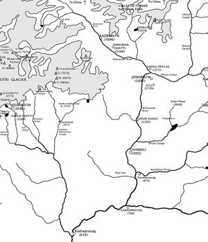
Mandani Ganga (मंदानी गंगा) is a tributory river of Vasuki River and originates from Mandani Parbat (6190 m) in the state of Uttarakhand, India.
Variants
- Mandani Parbat (मंदानी परबत)
- Mandani Parvata (मंदानी पर्वत)
- Mandani River (मंदानी नदी)
Origin
Jat clans
History
Mandani (मंडाणी) was mother of Cyrus (c. 600 BC or 576 BC–530 BC), commonly known as Cyrus the Great, was the founder of the Achaemenid Empire. She was of Manda Jat Gotra. She was daughter of the last Manda emperor Ishtuvegu (Astyages of the Greeks). She was was married to a small vassal prince of Ellam. It was forecast by the Magis that her issue will become the king of Asia and Europe.
Mandani Parbat
Mandani Parbat is a mountain of the Garhwal Himalaya in Uttarakhand India. The elevation of Mandani Parbat is 6,193 metres (20,318 ft). It is joint 140th highest located entirely within the Uttrakhand. Nanda Devi, is the highest mountain in this category. It lies between Chaukhamba IV, 6,854 metres (22,487 ft) and Sumeru Parbat, 6,351 metres (20,837 ft). Its nearest higher neighbor Chaukhamba IV lies 5.5 km east. It is located 8.4 km SE of Sumeru Parbat and 6.5 km NE lies Janhukut 6,829 metres (22,405 ft).
Gangotri Glacier lies on the northern side of Mandani Parbat from the snout of Gangotri Glacier comes out Bhagirathi River one of the main tributaries of river Ganga. On the south western side lies Mandani Glacier, from there comes out Mandani river after a short run it merges with Kali Ganga at Jalmalla near Kalimath which later joins Mandakini River below Naryankoti near Gupt Kashi later it joins Alaknanda River at Rudra Prayag which ultimately joins Bhagirathi River the other main tributaries of river Ganga at Dev Prayag and became Ganga there after.[1]
मंदानी पर्वत
मंदानी पर्वत उत्तराखंड भारत में गढ़वाल हिमालय का एक पर्वत है। मंदानी पर्वत की ऊंचाई 6,193 मीटर (20,318 फीट) है । यह पूरी तरह से उत्तराखंड में स्थित संयुक्त 140वां सबसे ऊंचा स्थान है। नंदा देवी , इस श्रेणी का सबसे ऊँचा पर्वत है। यह चौखम्बा IV, 6,854 मीटर (22,487 फीट) और सुमेरु पर्वत, 6,351 मीटर (20,837 फीट) के बीच स्थित है। इसका निकटतम उच्च पड़ोसी चौखम्बा IV 5.5 किमी पूर्व में स्थित है। यह सुमेरु पर्वत के 8.4 किमी दक्षिण पूर्व में स्थित है और 6.5 किमी पूर्वोत्तर जनहुकुट 6,829 मीटर (22,405 फीट) में स्थित है।
गंगोत्री ग्लेशियर गंगोत्री ग्लेशियर के थूथन से मंदानी पर्वत के उत्तरी किनारे पर स्थित है, भागीरथी नदी गंगा नदी की मुख्य सहायक नदियों में से एक है। दक्षिण पश्चिम की ओर मंदानी ग्लेशियर है, वहाँ से मंदानी नदी निकलती है, थोड़ी देर के बाद यह कालीमठ के पास जलमल्ला में काली गंगा में मिल जाती है जो बाद में गुप्त काशी के पास नारायणकोटि के नीचे मंदाकिनी नदी में मिल जाती है, बाद में यह रुद्र प्रयाग में अलकनंदा नदी में मिल जाती है जो अंततः भागीरथी में मिलती है। देव प्रयाग में गंगा नदी की अन्य मुख्य सहायक नदियाँ नदी और उसके बाद गंगा बन गईं।
External links
References
Back to Rivers

