Pasa
| Author:Laxman Burdak, IFS (Retd.) |

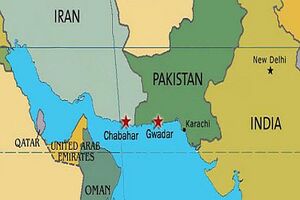
Pasa is a village in Sand-e Mir Suiyan Rural District, Dashtiari District, Chabahar County, Sistan and Baluchestan Province, Iran.
Variants
- Pasabandar (Persian: پسابندر, also Romanized as Pasā Bandar
- Pasā
- Pas Bandar
- Fasa-Kuri
Location
It is the southernmost town of Iran.
History
Mention by Pliny
Pliny[1] mentions....They (The fleet of Alexander commanded by Oncsicritus sailed from India into the heart of Persia) then came to the island of Athothradus, and those called the Gauratæ, upon which dwells the nation of the Gyani; the river Hyperis15 , which discharges itself midway into the Persian Gulf, and is navigable for merchant ships; the river Sitiogagus, from which to Pasargadæ16 is seven days' sail; a navigable river known as the Phristimus, and an island without a name; and then the river Granis17, navigable for vessels of small burden, and flowing through Susiane; the Deximontani, a people who manufacture bitumen, dwell on its right bank. The river Zarotis comes next, difficult of entrance at its mouth, except by those who are well acquainted with it; and then two small islands; after which the fleet sailed through shallows which looked very much like a marsh, but were rendered navigable by certain channels which had been cut there.
15 Forbiger has suggested that this may be the same as the modern Djayrah.
16 Mentioned again in c. 29 of the present Book. Its modern name is Pasa or Fasa-Kuri, according to Parisot.
17 Supposed to be the stream called by D'Anville and Thevenot the Boschavir, the river of Abushir or Busheer.
References
Back to Jat Places in Iran

