Ramban
| Author:Laxman Burdak, IFS (R) |


Ramban (Hindi: रामबन) is a town and district in Jammu and Kashmir.
Variants
Location
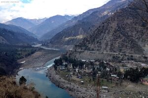
Ramban is located in the lap of Pir Panjal range of the mighty Himalayas. Ramban town is located at 33.25°N 75.25°E. on the right bank of River Chenab that is also known as 'Chandrabhaga' river. The town is located on National Highway-1A (now NH44) at about 150 km from Jammu and about 150 km from Srinagar making it almost a central point on Jammu-Srinagar National Highway.
Administrative divisions
Presently District Ramban in Jammu and Kashmir is divided into two tehsils: Ramban and Banihal.
The district is further divided into four blocks: Ramban, Banihal, Gool and Ramsu.
History

C.E. Bats writes in his book, ‘The Gazetteer of Kashmir’, that before the formation of the J&K State in 1846, there was a small village consisting of 15 houses on the right bank of Chenab river known as Nashband (later 'Ramban'). When Raja Gulab Singh of Jammu became the Maharaja of J&K State, he adopted the Jammu-Udhampur-Banihal route to reach Srinagar for the movement of royal caravans. In this process, Ramban received the status of halting station for the royal caravans. The Dogras constructed a pucca building near present Ramban and a wooden bridge for the crossing of Chenab River. Sukhdev Singh Chadak writes in his book Maharaja Ranbir Singh that Maharaja passed an order for a cart road from Jammu to Srinagar via Banihal and a suspension bridge over Chenab River at Ramban. This road became a national highway; it is being converted into four lanes. With the development of this road, the halting station Ramban also developed significantly and now it has got the status of district headquarters.[1]
रामबन
रामबन (उर्दू: : رام بن) भारत के जम्मू और कश्मीर प्रदेश का एक नगर है। यह रामबन ज़िले का मुख्यालय है और चिनाब नदी के किनारे बसा हुआ है। राष्ट्रीय राजमार्ग 44 से सड़क द्वारा कई अन्य स्थानों से जोड़ता है।
C.E. Bats ने अपनी पुस्तक ‘The Gazetteer of Kashmir’ में लिखा है कि जम्मू और कश्मीर राज्य के गठन 1846 से पूर्व चिनाब नदी के किनारे रामबन एक छोटा सा गाँव था और 'नशबंद' नाम से जाना जाता था जो बाद में रामबन नाम से जाना गया। जम्मू के राजा गुलाब सिंह जब जम्मू और कश्मीर राज्य के महाराजा बन गए तब वे श्रीनगर जाने के लिए जम्मू-उधमपुर-बनिहाल रूट लेते थे और रामबन एक शाही हाल्ट स्टेशन बन गया तबसे इसका महत्व बढ़ गया।

