Tiruchirapalli
| Author:Laxman Burdak, IFS (R) |


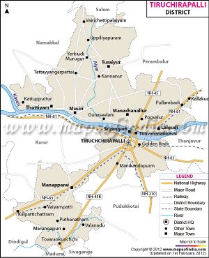
Tiruchirappalli (तिरुचिरापल्ली) is a city and district in the Indian state of Tamil Nadu.
Variants
- Aur-Thaur (by the historian Ptolemy)
- Orthoura (by the historian Ptolemy)
- Trichanapalli त्रिचनापल्ली = Trishirapalli त्रिशिरापल्ली
- Nichulapura (निचुलपर) (AS, p.415),
- Nichulapura निचुलपुर, दे. Trichanapalli त्रिचनापल्ली, (AS, p.500)
- Trichinopoly (commonly referred to in English)
- Trichy (shortened form)
- Tiruchi (shortened form)
- Urayiyura (उरयियूर) = Uragapura (उरगपुर) (AS, p.100)
- Trishirapalli (त्रिशिरापल्ली)
- Trichanapalli (त्रिचनापल्ली)
- Trishirapalli त्रिशिरापल्ली = Trichanapalli त्रिचनापल्ली (AS,p.418)
- Tiruchchirappalli (तिरुचिरापल्ली)
- Tiruchchirapali (तिरुचिरापल्ली)
- Trishirapuram
Location
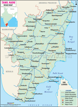
Located 322 kms south of Chennai and 374 kms north of Kanyakumari, Tiruchirappalli sits almost at the geographic centre of the state. The Cauvery Delta begins 16 kms west of the city where the Kaveri river splits into two, forming the island of Srirangam, which is now incorporated into the Tiruchirappalli City Municipal Corporation.
Etymology
According to Hindu mythology, Tiruchirappalli derives its name from the three-headed demon Trishira, who meditated on the god Shiva near the present-day city to obtain favours from the god. An alternative derivation is that the source of the city's name is the Sanskrit word "Trishirapuram"—Trishira, meaning "three-headed", and palli or puram meaning "city".[1][2]
Telugu scholar C. P. Brown has proposed that Tiruchirappalli might be a derivative of the word Chiruta-palli meaning "little town". Orientalists Henry Yule and Arthur Coke Burnell have speculated that the name may derive from a rock inscription carved in the 16th century in which Tiruchirappalli is written as Tiru-ssila-palli, meaning "holy-rock-town" in Tamil. Other scholars have suggested that the name Tiruchirappalli is a rewording of Tiru-chinna-palli, meaning "holy little town".[3][4]
The Madras Glossary gives the root as Tiruććināppalli or the "holy (tiru) village (palli) of the shina (Cissampelos pareira) plant".[5]
Historically, Tiruchirappalli was commonly referred to in English as "Trichinopoly".[6] The shortened forms "Trichy" or "Tiruchi" are used in common parlance.
History
Tiruchirappalli is one of the oldest inhabited cities in Tamil Nadu; its earliest settlements date back to the second millennium BC.[7] Uraiyur, the capital of the Early Cholas for 600 years from the 3rd century BC onwards,[8] is a suburb of present-day Tiruchirappalli.[9][10] The city is referred to as Orthoura by the historian Ptolemy in his 2nd-century work Geography.[11]
Tiruchirappalli's recorded history begins in the 3rd century BC, when it was under the rule of the Cholas. The city has also been ruled by the Mutharaiyars, Pandyas, Pallavas, Vijayanagar Empire, Nayak Dynasty, the Carnatic state and the British. The most prominent historical monuments in Tiruchirappalli include the Rockfort, the Ranganathaswamy temple at Srirangam and the Jambukeswarar temple at Thiruvanaikaval. The archaeologically important town of Uraiyur, capital of the Early Cholas, is now a suburb of Tiruchirappalli. The city played a critical role in the Carnatic Wars (1746–1763) between the British and the French East India companies.
Jat History
Dr Naval Viyogi[12] has mentioned the history of Sor Jat clan. According to him Cher, Chola and Pandyas have been important indigenous tribes of Ancient India. H.L. Kosare [13] puts forth his opinion on their origin and history. Urgapur was one of the towns of Nagas of southern region. We have enough information on this issue. Ptolemy has informed that the name of the chief city of southern Cholas was Aur-Thaur. Aur-Thaur was capital of Shor Nagas and it was under Shoartai [14]. The word Shor is synonymous of Sor or Chol of Tamil language. It is quite clear from the name of Shor nagas that Aur-Thaur was the capital of the naga kings; whosoever, he was called Shor (Chola) because he was the ruler of Shor-Tai.[15]
तिरुचिरापल्ली परिचय
तिरुचिरापल्ली (त्रिचि/तिरुची) भारत के तमिलनाडु प्रान्त का एक शहर और एक जिलाहै। प्राचीन काल में चोल साम्राज्य का एक महत्वपूर्ण हिस्सा रहा है. यह स्थान त्रिची के नाम से भी प्रसिद्ध है। यह शहर कावेरी नदी के तट पर बसा हुआ है। यह स्थान विशेष रूप से विभिन्न मंदिरों जैसे श्री रंगानाथस्वामी मंदिर, श्री जम्बूकेश्वरा मंदिर और वरैयूर आदि के लिए प्रसिद्ध है। शहर के मध्य से कावेरी नदी गुजरती है। वर्तमान समय में तिरूचिरापल्ली का एक महत्वपूर्ण हिस्सा वरैयूर है, यह चोल साम्राज्य की राजधानी था।
तिरूचिरापल्ली में कुछ समय तक मुगल शासकों ने भी राज किया। इसके पश्चात् इस पर विजयनगर के शासकों ने कब्जा किया। विजयनगर के शासकों के राज्यपाल ने इस क्षेत्र में 1736 ई. तक शासन किया। इनका नाम विश्वनाथ नायक था। इन्होंने उस समय तिप्पकुलम और किले का निर्माण करवाया था। बाद में यह नायक वंश के अधीन आया। इसके कुछ वर्षो के बाद तिरूचिरापल्ली पर चांद साहिब और मोहम्मद अली ने शासन किया। आखिर में यह स्थान अंग्रेजों के हाथों में चला गया। जल्द ही यह क्षेत्र ईस्ट इंडिया कम्पनी को दे दिया गया। यह क्षेत्र कर्नाटक युद्ध की पूर्वसंध्या पर एक समझौते के तहत ईस्ट इंडिया कम्पनी को दिया गया था। यह जिला ब्रिटिशों के अधीन लगभग 150 वर्षो तक रहा।
त्रिचनापल्ली
त्रिचनापल्ली = त्रिशिरापल्ली (AS, p.415): किंवदंती के अनुसार त्रिशिर नामक राक्षस का ग्राम (पल्ली) होने के कारण यह नगरी त्रिशिरापल्ली कहलाई. ऐसी मान्यता है कि त्रिशिर राक्षस का वध भगवान शिव ने इसी स्थान पर किया था। यह नगरी मद्रास से 250 मील दूर कावेरी नदी के तट पर अवस्थित है। त्रिचनापल्ली का दुर्ग पल्लव कालीन है। यह एक मील लम्बा और आधा मील चौड़ा समकोणाकार बना हुआ है और 272 फुट ऊँची पहाड़ी पर स्थित है। शिखर पर जाते समय पल्लव नरेशों के समय में निर्मित सौ स्तंभों का एक मंडप और कई [p.415]: गुहा मंदिर भी दिखाई पड़ते हैं। पहले दुर्ग के चारों ओर एक खाई थी और परकोटा खिंचा हुआ था। खाई अब भर दी गई है। भीतर एक चट्टान पर भूतेश्वर शिव और गणेश के मंदिर स्थित हैं। चट्टान के दक्षिण में नवाब का महल है, जिसे 17वीं शती में चोकानायक ने बनवाया था। चट्टान और मुख्य प्रवेश द्वार के बीच में 'तेघकुलम्' या 'नौका सरोवर' है। गणपति मंदिर दुर्ग से 2 फलांग दूर है। अभिलेखों में त्रिचनापल्ली का एक नाम 'निचुलपर' भी मिलता है। [16]
यहाँ कर्नाटक की मसनद के दावेदार मुहम्मद अली ने 1751 ई. में शरण ली थी। फ़्राँसीसी तथा उनके आश्रित चन्दा साहब ने जब अर्काट को अपने अधिकार में कर लिया था, तो उन्हें अपना घेरा उठा लेना पड़ा था। 1753 ई. में यहाँ पर पुन: फ़्राँसीसियों के द्वारा घेरा डाला गया, किन्तु 1754 ई. में अंग्रेज़ों ने इस घेरे को तोड़ दिया। यह तब तक कर्नाटक के नवाब के अधीन रहा, जब तक भारतीय ब्रिटिश साम्राज्य में नहीं मिला लिया गया।
उरग - उरगपुर
विजयेन्द्र कुमार माथुर[17] ने लेख किया है ... उरग - उरगपुर (AS, p.100): उरगपुर चोल साम्राज्य की तीन राजधानियों में से पहली थी। महाकवि कालिदास ने 'उरग' का अपने महाकाव्य 'रघुवंश'[6,59] में उल्लेख किया है- 'अथोरगाख्यपुरस्य नाथं दौवारिकी देवसरूपमेत्य, इतश्चकोराक्षि विलोकयेति पूर्वानुशिष्टां निजगाद भोज्याम्'।
मल्लिनाथ ने इसकी टीका करते हुए लिखा है, 'उरगाख्यस्त पुरस्यपंड्यदेशे कान्यकुब्जतीरवर्ति नागपुरस्य'। इससे ज्ञात होता है कि 'उरगपुर' कान्यकुब्ज नदी के तट पर बसा हुआ था। एपिग्राफ़िका इंडिका 10,103 में उरगपुर को अशोक कालीन चोल देश की राजधानी बताया है, जिसे 'उरयियूर' भी कहते थे। यह 'त्रिशिरापल्ली' और 'त्रिचनापल्ली' का ही प्राचीन नाम था। मल्लिनाथ का नागपुर वर्तमान 'नेगापटम' (ज़िला राजमहेन्द्री- मद्रास) है।
चोल
विजयेन्द्र कुमार माथुर[18] ने लेख किया है ...1. चोल (AS, p.345): सुदूर दक्षिण का प्रदेश-- कोरोमंडल या चोलमंडल. महाभारत सभा पर्व है 31,71 में चोल या चोड़ प्रदेश का उल्लेख है. इसे सहदेव ने दक्षिण की दिग्विजय यात्रा के प्रसंग में जीता था-- 'पाण्ड्यांश च द्रविड़ांश्चैव सहितांश चॊड्र केरलैः'. चोड का पाठांतर चोड्र भी है. वन पर्व 51,22 में में चोलों का द्रविड़ों और आंध्रों के साथ उल्लेख है-- 'सवंङ्गाङ्गान स पौण्ड्रोड्रान सचॊल द्रविडान्धकान'. सभा पर्व 51 में केरल और चोल नरेशों द्वारा युधिष्ठिर को दी गई भेंट का उल्लेख है--'चंदनागरुचानन्तं मुक्तावैदर्य चित्रिका:, चोलश्च केरलश्चोभौ ददतु: पाण्डवायवै'.
अशोक के शिलालेख 13 में चोल का प्रत्यंत (पड़ोसी) देश के रूप वर्णन है. प्राचीन समय में यहां की मुख्य नदी कावेरी थी. चोल प्रदेश की राजधानी उरगपुर या वर्तमान त्रिशिरापल्ली (त्रिचनापल्ली, मद्रास) में थी. इसे उरयियूर भी कहते थे. किंतु कालिदास ने (रघुवंश 6,59) 'उरगाख्यपुर' को पाण्ड्य देश की राजधानी बताया है. अवश्य ही यह भेद इतिहास के विभिन्न कालों में इन दोनों पड़ोसी देशों की सीमाएं बदलती रहने के कारण हुआ होगा. चोल नरेशों ने प्राचीन काल और मध्यकाल में [p.346]: शासन की जनसत्तात्मक पद्धति शापित की थी जिसमें ग्राम पंचायतों और ग्राम समितियों का बहुत महत्व था. यह सूचना हमें चोल नरेशों के अनेक अभिलेखों से मिलती है.
External links
References
- ↑ Hemingway, Frederick Ricketts (1907). Madras District Gazetteers: Trichinopoly. 1. Government Press. p.2
- ↑ Yule, Sir Henry; Burnell, Arthur Coke (1903). "Trichinopoly". Hobson-Jobson: A glossary of colloquial Anglo-Indian words and phrases. J. Murray. Archived from the original on 15 December 2012., p. 938.
- ↑ Yule, Sir Henry; Burnell, Arthur Coke (1903). "Trichinopoly". Hobson-Jobson: A glossary of colloquial Anglo-Indian words and phrases. J. Murray. Archived from the original on 15 December 2012., p. 938.
- ↑ Jaques, Tony (2007). Dictionary of Battles and Sieges. 3. Greenwood Publishing Group. ISBN 978-0-313-33536-5. Handbook for India, Burma, and Ceylon. John Murray. 1920, p. 1025.
- ↑ Thani Nayagam, Xavier S. (1957). Tamil Culture. 6. Academy of Tamil culture., p. 324.
- ↑ Sastri, K. A. Nilakanta (1935). The Cōlas. University of Madras., p. 22.
- ↑ Sastri, K. A. Nilakanta (1935). The Cōlas. University of Madras., p. 19.
- ↑ Beck, Elisabeth (2006). Pallava Rock Architecture And Sculpture. Sri Aurobindo Institute of Research in Social Sciences, East West Books (India) Limited. ISBN 978-81-88661-46-6, p. 40.
- ↑ Caldwell, Robert (1881). A Political and General History of the District of Tinnevelly, in the Presidency of Madras: From the Earliest Period to Its Cession to the English Government in A.D. 1801. E. Keys, at the Government Press. p. 25.
- ↑ Dr Naval Viyogi: Nagas – The Ancient Rulers of India, p. 310
- ↑ H.L. Kosare, P.47
- ↑ E.A. 8 P-368
- ↑ D.R. Bhandarkar, Ram Prakash Ojha "Ashoka" PP 35-36
- ↑ Aitihasik Sthanavali by Vijayendra Kumar Mathur, p.415
- ↑ Aitihasik Sthanavali by Vijayendra Kumar Mathur, p.100
- ↑ Aitihasik Sthanavali by Vijayendra Kumar Mathur, p.345

