Surankote
| Author:Laxman Burdak, IFS (R) |

Surankote (सूरनकोट) is a tahsil town in Poonch district in the union territory of Jammu and Kashmir, India.
Variants
Location
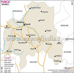
Surankote township is located at some 27 kilometres to the south-east of Poonch city and 221 kilometres from winter capital Jammu.
Jat Gotras
History
Surankote - Surankote is a small village situated on the banks of Suran River and has very charming valley surrounded by lofty peaks which are covered with snow during winter and is popularly called Pahalgam of Poonch. In Rajatarangini, this town was described as Sawernik in the past. Nearly in 1036 A.D. there was a big fort called Kote which ultimately changed to its present name of Surankote.[1]
Villages in Surankote tahsil
Town: 1. Surankote,
Villages: 1 Bafliaz, 2 Behrangala, 3 Buni Khet, 4 Chananser, 5 Chandi Marh, 6 Dandi Dhara, 7 Daraba, 8 Dhara Mohara, 9 Dodi, 10 Dogey, 11 Dundhak, 12 Fazal Abad, 13 Gaunthal, 14 Hari, 15 Kalar Kattal, 16 Lassana, 17 Lathung, 18 Mahara, 19 Malhan, 20 Marhote, 21 Mohra Bachhai, 22 Morha, 23 Pamrote , 24 Phagla, 25 Poshiana, 26 Potha, 27 Sailan, 28 Samote, 29 Sanei, 30 Sangla, 31 Sangliani, 32 Surankot, 33 Traran Wali,
Source' - https://www.census2011.co.in/data/subdistrict/19-surankote-punch-jammu-and-kashmir.html

