Surankote
| Author:Laxman Burdak, IFS (R) |

Surankote (सूरनकोट) is a tahsil town in Poonch district in the union territory of Jammu and Kashmir, India.
Variants
- Sabarnika (सबर्निक) : village revered in Lohara mentioned in Rajatarangini [1]
- Sawernik
- Savvernik
- Surankot
Location
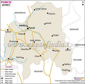
Surankote township is located at some 24 kilometres to the south-east of Poonch city and 221 kilometres from winter capital Jammu. Surankote is a Town in Surankote Block in Poonch District of Jammu & Kashmir State, India. It is located 24 KM towards East from District head quarters Poonch. It is a Block head quarter. Surankote Pin code is 185121 and postal head office is Samote . Pamrote ( 1 KM ) , Samote Upper ( 2 KM ) , Samote Lower ( 2 KM ) , Potha Upper ( 2 KM ) , Dandi Dhara ( 3 KM ) are the nearby Villages to Surankote. Surankote is surrounded by Bufliaz Block towards East , Balakote Block towards South , Mendhar Block towards west , Thana Mandi Block towards East . Punch , Rajauri , Baramula , Sopore are the nearby Cities to Surankote. This Place is in the border of the Poonch District and Rajauri District. Rajauri District Manjakote is South towards this place . [2]
Jat Gotras
History
Surankote - Surankote is a small village situated on the banks of Suran River and has very charming valley surrounded by lofty peaks which are covered with snow during winter and is popularly called Pahalgam of Poonch. In Rajatarangini, this town was described as Sawernik in the past. Nearly in 1036 A.D. there was a big fort called Kote which ultimately changed to its present name of Surankote.[3]
Lalitaditya had built Poonch city but at present there is no building existing on ground belonging to Lalitaditya except Ram Kund Temple Mendhar. Mr Stein who translated Rajatarangini, visited Poonch in 1892, identified a number of places like Loharkote (Loran), Attalika (Atoli), Saramber (Chamber Kanari), Savvernik (Surankote) mentioned in Rajatarangini. He could not locate Ram Kund as it was located in very remote area. Other proof is that Devadasis reported to Lalitaditya that they belonged to a nearby village known as Sover Dehmana, which is still existing near Narol, where Ram Kund Temple exists, known as Dharana instead of Dehmana.[4]
In Rajatarangini
Sabarnika (सबर्निक) village revered in Lohara is mentioned in Rajatarangini [5]
Rajatarangini[6] tells that ...Mallarjjuna was being carried by his servants on their shoulders, his legs being like those of a goat, [defective], he could not walk on the road. When he had passed the dangerous places and had arrived at the village Sabarnika, revered in Lohara, he was arrested by a Thakkura named Jaggika who had placed sentinels there.
Mallarjjuna (b. 1114-r. 1130-1132 AD) was a King of Loharkot. He succeeded Lothana. He was son of Sussala. He lost Kigdom at the age of 18 years in year 1132 AD.
Villages in Surankote tahsil
Town: 1. Surankote,
Villages: 1 Bafliaz, 2 Behrangala, 3 Buni Khet, 4 Chananser, 5 Chandi Marh, 6 Dandi Dhara, 7 Daraba, 8 Dhara Mohara, 9 Dodi, 10 Dogey, 11 Dundhak, 12 Fazal Abad, 13 Gaunthal, 14 Hari, 15 Kalar Kattal, 16 Lassana, 17 Lathung, 18 Mahara, 19 Malhan, 20 Marhote, 21 Mohra Bachhai, 22 Morha, 23 Pamrote , 24 Phagla, 25 Poshiana, 26 Potha, 27 Sailan, 28 Samote, 29 Sanei, 30 Sangla, 31 Sangliani, 32 Surankot, 33 Traran Wali,
Source - https://www.census2011.co.in/data/subdistrict/19-surankote-punch-jammu-and-kashmir.html
Tourism
Jat History

- Sajjan Singh Gahlawat (Major) (08.06.1966 - 23.10.1997), Shaurya Chakra, became martyr of militancy on 23.10.1997 in village Surankote in Poonchh district of Jammu and Kashmir. He was from Khedi Sadh village in Tehsil and District Rohtak of Haryana. Unit: 9 Madras Regiment.
External links
References
- ↑ Kings of Kashmira Vol 2 (Rajatarangini of Kalhana)/Book VIII (i), p.203
- ↑ http://www.onefivenine.com/india/villages/Poonch/Surankote/Surankote
- ↑ https://poonch.nic.in/places-of-interest/
- ↑ Kashmir Paradise, 29.3.2009
- ↑ Kings of Kashmira Vol 2 (Rajatarangini of Kalhana)/Book VIII (i), p.203
- ↑ Kings of Kashmira Vol 2 (Rajatarangini of Kalhana)/Book VIII (i), p.203

