Karkheh River
| Author: Laxman Burdak, IFS (R). |


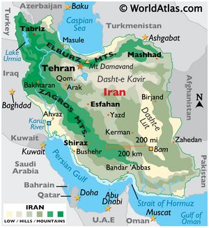
Karkheh or Karkhen is a river in Khūzestān Province Andimeshk city, Iran (ancient Susiana).
Variants of name
- Eulaeus River (Greek)
- Eulaeus/Eulæus (Greek)
- Eulaios
- Karkheh
- Karkhen
- Kara Su
- Gihon—one of the four rivers of Eden/Paradise to the Bible and as the Choaspes[1] in ancient times;
Jat clans
Location
It rises in the Zagros Mountains, and passes west of Shush (ancient Susa), eventually falling in ancient times into the Tigris just below its confluence with the Euphrates very near to the Iran-Iraq border. The river is currently the location of the Karkheh Dam and hydro-power plant in Iran.
Course
In modern times, after approaching within 16 kilometres of the Dez River, it turns to the southwest and then, northwest of Ahvaz, turns northwest and is absorbed by the Hawizeh Marshes that straddle the Iran–Iraq border. Its peculiarly sweet water was sacred to the use of the Persian kings.[3] Ancient names for the Karkheh should be treated as conjectural because the bed of the river has changed in historic times, and because a nearby watercourse between the Karkheh and the Dez River, the Shaur, confuses the identification.[4]
The problem with the ancient names is that while the Karkheh flows a kilometre or two west of Susa, another major watercourse flows parallel to the Karkheh within a few kilometres east of Susa. When these rivers are in flood stage, the entire area south of Susa can be flooded, as the waters of the two watercourses mingle. The watercourse a kilometre or two east of Susa, now called the Shaur, flows east between the Haft Tepe and Shaur ridges into the Dez River, north of where the Dez and Karun rivers merge. At some previous time, the Karkheh may have joined the eastern end of the Shaur. The timing of these changes is not known with any certainty. The ancient name of the Shaur may have been the Choaspes.
The river is mentioned in the Bible, Book of Daniel 8:2,16, and should not be confused with the Choaspes River in modern-day Afghanistan, which flows into the Indus.
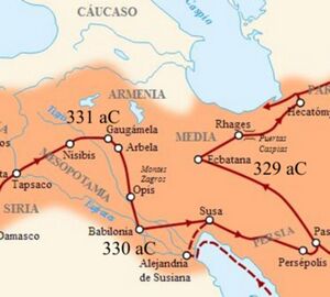
Arrian[5] writes....Alexander now ordered Hephaestion to lead the main body of the infantry as far as the Persian Sea, while he himself, his fleet having sailed up into the land of Susiana, embarked, with the shield-bearing guards and the body-guard of infantry; and having also put on board a few of the cavalry Companions, he sailed down the river Eulaeus to the sea.[1] When he was near the place where the river discharges itself into the deep, he left there most of his ships, including those which were in need of repair, and with those especially adapted for fast sailing he coasted along out of the river Eulaeus through the sea to the mouth of the Tigres. The rest of the ships were conveyed down the Eulaeus as far as the canal which has been cut from the Tigres into the Eulaeus, and by this means they were brought into the Tigres. Of the rivers Euphrates and Tigres which enclose Syria between them, whence also its name is called by the natives Mesopotamia,[2] the Tigres flows in a much lower channel than the Euphrates, from which it receives many canals; and after taking up many tributaries and its waters being swelled by them, it falls into the Persian Sea.[3] It is a large river and can be crossed on foot nowhere as far as its mouth,[4] inasmuch as none of its water is used up by irrigation of the country. For the land through which it flows is more elevated than its water, and it is not drawn off into canals or into another river, but rather receives them into itself. It is nowhere possible to irrigate the land from it. But the Euphrates flows in an elevated channel, and is everywhere on a level with the land through which it passes. Many canals have been made from it, some of which are always kept flowing, and from which the inhabitants on both banks supply themselves with water; others the people make only when requisite to irrigate the land, when they are in need of water from drought.[5] For this country is usually free from rain. The consequence is, that the Euphrates at last has only a small volume of water, which disappears into a marsh. Alexander sailed over the sea round the shore of the Persian Gulf lying between the rivers Eulaeus and Tigres; and thence he sailed up the latter river as far as the camp where Hephaestion had settled with all his forces. Thence he sailed again to Opis, a city situated on that river.[6] In his voyage up he destroyed the weirs which existed in the river, and thus made the stream quite level. These weira had been constructed by the Persians, to prevent any enemy having a superior naval force from sailing up from the sea into their country. The Persians had had recourse to these contrivances because they were not a nautical people; and thus by making an unbroken succession of weirs they had rendered the voyage up the Tigres a matter of impossibility. But Alexander said that such devices were unbecoming to men who are victorious in battle; and therefore he considered this means of safety unsuitable for him; and by easily demolishing the laborious work of the Persians, he proved in fact that what they thought a protection was unworthy of the name.
1. The Eulaeus is now called Kara Su. After joining the Ooprates it was called Pasitigris. It formerly discharged itself into the Persian Gulf, but now into the Shat-el-Arab, as the united stream of the Euphrates and Tigris is now called. In Dan. viii. 2, 16, it is called Ulai. Cf. Pliny, vi. 26, 31; xxxi. 21.
2. The Greeks and Romans sometimes speak of Mesopotamia as a part of Syria, and at other times they call it a part of Assyria. The Hebrew and native name of this country was Aram Naharaim, or "Syria of the two rivers."
3. The Tigris now falls into the Euphrates.
4. Cf. Arrian, iii. 7, supra; Curtius, iv. 37.
5. Cf. Strabo, xvi. 1; Herodotus, i, 193; Ammianus, xxiv. 3, 14.
6. Probably this city stood at the junction of the Tigris with the Physcus, or Odoneh. See Xenophon (Anab. ii. 4, 26); Herodotus, i. 189; Strabo, (xvi. 1) says that Alexander made the Tigris navigable up to Opis.
Mention by Pliny
Choaspes: Pliny[6] mentions....After this, it (Tigris) receives the Choaspes17, which comes from Media; and then, as we have already stated,18 flowing between Seleucia and Ctesiphon, discharges itself into the Chaldæan Lakes, which it supplies for a distance of seventy miles. Escaping from them by a vast channel, it passes the city of Charax to the right, and empties itself into the Persian Sea, being ten miles in width at the mouth. Between the mouths of the two rivers Tigris and the Euphrates, the distance was formerly twenty-five, or, according to some writers, seven miles only, both of them being navigable to the sea. But the Orcheni and others who dwell on its banks, have long since dammed up the waters of the Euphrates for the purposes of irrigation, and it can only discharge itself into the sea by the aid of the Tigris.
17 A river of Susiana, which, after passing Susa, flowed into the Tigris, below its junction with the Euphrates. The indistinctness of the ancient accounts has caused it to be confused with the Eulæus, which flows nearly parallel with it into the Tigris. It is pretty clear that they were not identical. Pliny here states that they were different rivers, but makes the mistake below, of saying that Susa was situate upon the Eulæus, instead of the Choaspes. These errors may be accounted for, it has been suggested, by the fact that there are two considerable rivers which unite at Bund-i- Kir, a little above Ahwaz, and form the ancient Pasitigris or modern Karun. It is supposed that the Karun represents the ancient Eulæus, and the Kerkhah the Choaspes.
18 In c. 26 of the present Book. The custom of the Persian kings drinking only of the waters of the Eulæus and Choaspes, is mentioned in B. xxxi. c. 21.
References
- ↑ Bosworth, A. B. (1993). Conquest and Empire: The Reign of Alexander the Great. Cambridge University Press. p. 88. ISBN 0-521-40679-X.
- ↑ Potts, Daniel T. (1999). The Archaeology of Elam: Formation and Transformation of an Ancient Iranian State. Cambridge University Press. p. 236. ISBN 0-521-56496-4. "One refers to his camp while on campaign and to action near the Ulai, the modern Karkheh river, in Khuzistan"
- ↑ Hazlitt, William (1851). "page 108". The Classical Gazetteer. Archived from the original on 2007-03-03.
- ↑ John Hansman, "Charax and the Karkheh," Iranica Antiqua VII(1967), pp.21-58, and Michael J. Kirkby, "Land and Water Resources of the Deh Luran and Khuzistan Plains," Appendix I, in Studies in the Archaeological History of the Deh Luran Plain. The Excavation of Chagha Sefid, edited by Frank Hole, pp. 251-288. Memoirs, no. 9, Ann Arbor, Museum of Anthropology, University of Michigan
- ↑ The Anabasis of Alexander/7a, Ch.7
- ↑ Natural History by Pliny Book VI/Chapter 31

