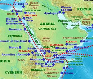
Ocelis
| Author:Laxman Burdak, IFS (R) |


Ocelis was a port on the Red Sea, on the Arabian side near or at Bab al-Mandeb, the strait separating the Red Sea from the Gulf of Aden, part of the ancient reckoning of Arabia Felix. The site of Ocelis is tentatively identified as at Khor Ghurayrah (Shaykh Sa'id) in Yemen.[1][2]
Variants
- Okelis (Ancient Greek: Ὄκηλις ἐμπόριον)
- romanized: Okêlis emporion; and Ὤκηλις
- Acila or Akila (Ἀκίλα)
Jat Gotras Namesake
- Aki = Acila (Pliny.vi.32, Pliny.vi.35)
- Okla = Ocelis = Acila (Pliny.vi.32)
History
It is placed by Ptolemy a little to the north of the straits of the Red Sea.[3] It belonged to the Elisari, and was subject to Cholebus.[4] The place also sometimes appears as Acila or Akila (Ἀκίλα).[5][6][7]
Ocelis belonged to the South Arabian kingdom of Saba-Himyar and is known as a stop on the maritime route from Egypt to India in the 1st centuries CE. In the 1st century, Periplus Maris Erythraei describes it as "not so much a port of trade as harbour, watering station, and the first place to put in for those sailing on".[8] Pliny the Elder reports their destination and describes Ocelis as the first stop on the sea journey from Egypt to India.[9]
Ocelis was visited by traders coming over from the African side on rafts with aromatics, myrrh, ivory and tortoise shell, this being the only report of African navigation in this work.[10]
The site of Ocelis is tentatively identified as at Khor Ghurayrah (Shaykh Sa'id) in Yemen.[11][12] During the 18th century, a port identified as Ocelis[13] was known "An extract of a journey through part of Arabia Felix", p. 167 in A Collection of Curious Travels and Voyages, London: John Ray, 1705 OCLC 219498067.Ziden. It was described as a settlement of 500 houses with over a hundred ships in the anchorage.[14]
Mention by Pliny
Pliny[15] mentions....Passengers generally set sail at midsummer, before the rising of the Dog-star, or else immediately after, and in about thirty days arrive at Ocelis28 in Arabia, or else at Cane29, in the region which bears frankincense. There is also a third port of Arabia, Muza30 by name; it is not, however, used by persons on their passage to India, as only those touch at it who deal in incense and the perfumes of Arabia.
More in the interior there is a city; the residence of the king there is called Sapphar31, and there is another city known by the name of Save. To those who are bound for India, Ocelis is the best place for embareation.
28 Now called Gehla, a harbour and emporium at the south-western point of Arabia Felix.
29 An emporium or promontory on the southern coast of Arabia, in the country of the Adramitæ, and, as Arrian says, the chief port of the increase-bearing country. It has been identified by D'Anville with Cava Canim Bay, near a mountain called Hissan Ghorab, at the base of which there are ruins to be seen.
30 Probably the modern Mosch, north of Mokha, near the southern extremity of Arabia Felix.
31 Its ruins are now known as Dhafar. It was one of the chief cities of Arabia, standing near the southern coast of Arabia Felix, opposite the modern Cape Guardafui.
Mention by Pliny
Pliny[16] mentions Arabia....We then come to the Sabæi, a nation of Scenitæ29, with numerous islands, and the city of Acila30, which is their mart, and from which persons embark for India.
29 Or the Tent-Dwellers, the modern Bedouins.
30 By some geographers identified with the Ocelis or Ocila, mentioned in c. 26, the present Zee Hill or Ghela, a short distance to the south of Mocha, and to the north of the Straits of Bab-el-Mandeb. Hardouin says, however, that it was a different place, Acila being in the vicinity of the Persian Gulf, in which he appears to be correct.
Mention by Pliny
Pliny[17] mentions Ethiopia....All these differences, however, have since been settled; for the persons sent by Nero for the purposes of discovery have reported that the distance from Syene to Meroë is eight hundred and seventy-one miles, the following being the items. From Syene to Hiera Sycaminos14 they make to be fifty-four miles, from thence to Tama seventy-two, to the country of the Evonymitæ15, the first region of Æthiopia, one hundred and twenty, to Acina fifty-four, to Pittara twenty-five, and to Tergedus one hundred and six.
14 Or the sacred "sycamore tree."
15 Situate beyond the Great Cataract, and on the western bank.
External links
References
- ↑ Richard Talbert, ed. (2000). Barrington Atlas of the Greek and Roman World. Princeton University Press. p. 4, and directory notes accompanying.
- ↑ Lund University. Digital Atlas of the Roman Empire.
- ↑ Ptolemy. The Geography. Vol. 1.7.4, 1.15.11, 6.7.7, 8.22.7.
- ↑ Hudson, Geog. Min. tom. i. p. 14; Ptolemy. The Geography. Vol. 6.7.7.
- ↑ Strabo. Geographica. Vol. p. 769. Page numbers refer to those of Isaac Casaubon's edition.
- ↑ Pliny. Naturalis Historia. Vol. 6.23.26, 28, 32.
- ↑ Ptolemy. The Geography. Vol. 6.7.7.
- ↑ Casson, L. 1989. The Periplus Maris Erythraei. Princeton: Princeton University Press.
- ↑ Pliny. Naturalis Historia. Vol. 6.104.
- ↑ Casson, L. 1989. The Periplus Maris Erythraei. Princeton: Princeton University Press.
- ↑ Richard Talbert, ed. (2000). Barrington Atlas of the Greek and Roman World. Princeton University Press. p. 4, and directory notes accompanying.
- ↑ Lund University. Digital Atlas of the Roman Empire.
- ↑ Alexander Macbean, "Acila", A Dictionary of Ancient Geography, London: G. Robinson and T. Cadell, 1773 OCLC 642566361.
- ↑ "An extract of a journey through part of Arabia Felix", p. 167 in A Collection of Curious Travels and Voyages, London: John Ray, 1705 OCLC 219498067.
- ↑ Natural History by Pliny Book VI/Chapter 26
- ↑ Natural History by Pliny Book VI/Chapter 32
- ↑ Natural History by Pliny Book VI/Chapter 35

