Kunar River
| Author:Laxman Burdak, IFS (Retd.) |

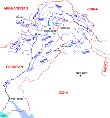
Kunar River (कुनार नदी) also known as Chitral River is about 480 km long, located in northern Pakistan. Rigveda mentions a river named Kusava (कुसावा) (RV IV.18.8.) which has been identified with the Kunar River in Pakistan.
Location
Origin of name
Alexander Cunningham[1] writes that The name of Kophes (Kabul) is as old as the time of the Vedas, in which the Kubha river is mentioned as an affluent of the Indus. The Kunar River, the Kurram River, and the Gomal rivers to the west, and the Kunihar River to the east of the Indus, all of which are derived from the Scythian ku, " water."
Course
The river system is fed from melting glaciers and snow of the Hindu Kush mountains. It is part of the Indus / Sindh watershed. It was once called the Kama River.[2]
The river rises in the far north of Chitral District in Pakistan. Downstream as far as Mastuj it is known as the Yarkhun River from there to its confluence with the Lutkho River just north of the important regional centre of Chitral it is called the Mastuj River.[3] It is then called the Chitral River, before flowing south into the upper Kunar Valley. At the confluence of the Pech it meets Asadabad, historically Chaga Sarai. The Kunar River empties into the Kabul River just to the east of the city of Jalalabad in Afghanistan. The combined rivers then flow eastwards into Pakistan, roughly following the Grand Trunk Road through the Khyber Pass, and joining the Indus River at the city of Attock.
History
V S Agarwal [4] writes names of some important tribes in the Ganapatha, which deserve to be mentioned as being of considerable importance. We are indebted to the Greek historians of Alexander for the information that most of these were republics. These tribes include - Hāstināyana, Āśvāyana, Āśvakāyana. The first is mentioned in Sutra VI.4.174, the second in IV.1.110, and the third in Naḍadi gana (IV.1.99)
[p.454]: While describing Alexander’s campaign from Kapisa towards the Indus through Gandhara, the Greek historians mention three warlike peoples, viz., Astakenoi, with capital at Peukelaotis, the Aspasioi in the valley of Kunar or Chitral River and the Assakenoi settled between the Swat and the Panjkora rivers, with the capital at Massaga, and more especially in the mountainous regions of the Swat. The Paninian evidence throws light on these three names for the first time:
- (a) Aspasioi = Ashvayana; in Alisang or Kunar Valley
- (b) Assakenoi = Ashvakayana; in the Swat valley and highlands, with capital at Mashakavati
- (c) Astakenoi = Hastinayana; near the confluence of Swat with the the Kabul, with capital at Pushkalavati.
The Asvayanas and the Asvakayanas were the bravest fighters of all, being strongly entrenched in their mountainous fortresses. Alexander himself directed the operations against them. The Ashvakayana capital at Massaga or Masakavati is given in Bhashya as the name of a river (IV.2.71), that should be looked for in that portion of the Suvastu in its lower reaches where Mazaga or Massanagar is situated on it at a distance of 24 miles from Bajaur in the Yusufzai country. In times of danger the Asvakayanas withdrew into the impregnable defences of their hilly fortress which the Greeks have named Aornos. It appears to be same as Varaṇā of the Ashtadhyayi (see ante, p.69, for its identification with modern Uṇrā on the Indus). The Greeks also mention another of their towns, viz., Arigaeon, which commanded the road between the Kunar and Panjkira valleys, and is comparable with Ārjunāva of the Kashika (ṛijunāvām nivāso deshaḥ, IV.2.69).
Jat clans
External links
References
- ↑ Alexander Cunningham: The Ancient Geography of India/Kabul,pp. 37
- ↑ The Afghan War, 1838-1842: From the Journal and Correspondence of the Late Major - General Augustus Abbott - with Charles Rathbone Low, Publisher R. Bentley and son, 1879,
- ↑ Pakistan and the Karakoram Highway
- ↑ V S Agarwal, India as Known to Panini,p.453-454

