Hormuz
| Author:Laxman Burdak, IFS (R) |

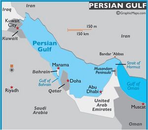
Hormuz is a strait between the Persian Gulf and the Gulf of Oman. It provides the only sea passage from the Persian Gulf to the open ocean and is one of the world's most strategically important choke points.
Variants of name
- Ormuzd (Anabasis by Arrian, p. 243.)
- Armozei (Pliny.vi.28)
- Hormoz
- Hurmogh
- Hurmoz
- Hurmuz
- Ormus
- Ormuz
- Kharmuz = Hormuz[1]
- Strait of Hormuz
Location
On the north coast lies Iran, and on the south coast the United Arab Emirates and Musandam, an exclave of Oman. At its narrowest, the strait has a width of 29 nautical miles (54 km).[2]
History
At the time of Alexander's invasion Karamania was a satrapy on the Persian Gulf coast west of Hormoz; it was bounded on the east by Gedrosia. Some authors, such as Ptolemy called the northern deserts, which stretched as far as Parthia and Aria, "desert Carmania", apparently to be distinguished from Carmania proper, which was a cultivated and fertile region, known for its teak wood. Alexander erected a pillar/s on the Carmanian coast, possibly marking the edge of his empire, and established a city at a currently unknown site, probably in the area of Gavkosh or Gulashkird. Marco Polo later visited this town.
By the end of the rule Antiochus IV in 163 BC, the Seleucid empire had lost control of their eastern Persia area, including Persis and Seistan.
We must assume that Carmania, had become an independent kingdom called Ormuz,[3] the capital of which was Arkiotisas in the upper Jiroft basin. Numismatic evidence indicates an otherwise unknown dynasty of kings, Bellaios, Tigraios and Goaisos. Arkiotisas was briefly an important post on the trade route from India to Persepolis and thence Rome, and was clearly identified in the Peutinger Table as a half-way house between Seistan and Ormuz, there may have been visited by Marco Polo. The kingdom was after two centuries was absorbed into the Bactrian or Parthian kingdoms.
The opening to the Persian Gulf was described, but not given a name, in the Periplus of the Erythraean Sea, a 1st-century mariner's guide:
- "At the upper end of these Calaei islands is a range of mountains called Calon, and there follows not far beyond, the mouth of the Persian Gulf, where there is much diving for the pearl-mussel. To the left of the straits are great mountains called Asabon and to the right there rises in full view another round and high mountain called Semiramis; between them the passage across the strait is about six hundred stadia; beyond which that very great and broad sea, the Persian Gulf, reaches far into the interior. At the upper end of this gulf there is a market-town designated by law called Apologus, situated near Charaex Spasini and the River Euphrates."....— Periplus of the Erythraean Sea, Chapter 35
In the 10th–17th centuries AD, the Kingdom of Ormus, which seems to have given the strait its name, was located here. Scholars, historians and linguists derive the name "Ormuz" from the local Persian word هورمغ Hur-mogh meaning date palm.[4] In the local dialects of Hurmoz and Minab this strait is still called Hurmogh and has the aforementioned meaning. The resemblance of this word with the name of the Persian god هرمز Hormoz (a variant of Ahura Mazda) has resulted in the popular belief that these words are related.
External links
References
- ↑ H. W. Bellew:An Inquiry Into the Ethnography of Afghanistan,p.102
- ↑ Alejandra Roman & Administration. "Strait of Hormuz". The Encyclopedia of Earth.
- ↑ Pliny XI 110.
- ↑ Municipality of Minab, (in Persian).

