Parthia
| Author:Laxman Burdak, IFS (R) |
Parthia (पर्थिया) is a region of north-eastern Iran, best known for having been the political and cultural base of the Arsacid dynasty, rulers of the Parthian Empire. Parthia is the modern Khorasan.[1]
Variants
- Parthia and Parthians (Anabasis by Arrian, p. 155, 161, 168, 181, 182, 185, 191, 197, 216, 278, 361, 378, 387.)
- Parthi (Pliny.vi.29)
- Parthia (Pliny.vi.39)
- Parthian
- Parthians
- Parthian Empire/Parthian empire
- Parthava (पार्थव) - the region Parthia (Old Persian)
- Pritha (पृथा) refers to Kuntī, Krishna’s aunt. She was the daughter of Śūrasena, the sister of Vasudeva, the wife of Pandu, and the mother of the three eldest Pandavas (Yudhisthira, Bhima, Arjuna) and Karna. (
- Partha (पार्थ) - Partha is other name of Arjuna derived from Pritha meaning son of Pritha. अर्जुन का ही दूसरा नाम है भगवान श्री कृष्णा ने अर्जुन को पार्थ ही सम्बोधन दिया था ।महाभारत के युद्ध में श्री भगवत गीता का ज्ञान देते समय। इसलिए कुछ तोमर जाट पार्थ को उपनाम के रूप में काम लेते है क्योकि तोमर जाट पाण्डुवंशी अर्जुन के ही वंशज हैं।
Jat Gotras Namesake
- Jats = Parthian Jats = Parthia and Parthians (Anabasis by Arrian, p. 155, 161, 168, 181, 182, 185, 191, 197, 216, 278, 361, 378, 387.)
Jat Gotras Namesake
- Jats = Parthian Jats = Parthi (Pliny.vi.29)
- Jats = Parthian Jats = Parthia (Pliny.vi.39)
Location
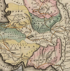
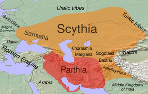
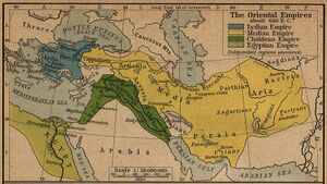
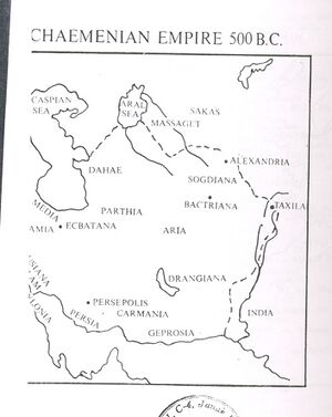
Parthia roughly corresponds to the western half of Khorasan region in northeastern Iran. It was bordered by the Kopet Dag mountain range in the north and the Dasht-e-Kavir desert in the south. It bordered Media on the west, Hyrcania on the north west, Margiana on the north east, and Aria on the south east.
During Arsacid times, Parthia was united with Hyrcania as one administrative unit, and that region is therefore often (subject to context) considered a part of Parthia proper.
Origin of name
- Parthava = 'of the Parthians' in Old Persian. The name "Parthia" is a continuation from Latin Parthia, from Old Persian Parthava, which was the Parthian language self-designator signifying "of the Parthians" who were an Iranian people.
- Parthians - descendents of Prithu, an important section of the Sakas. [3]
Parthava derived from Prithu
Parthava in Sanskrit glossary: Source: DDSA: The practical Sanskrit-English dictionary
Pārthava (पार्थव).—a. Belonging to पृथु (pṛthu); अस्मिन् कृतमतिर्मत्येः पार्थवीं गतिमाप्नुयात् (asmin kṛtamatirmatyeḥ pārthavīṃ gatimāpnuyāt) Bhāg.4.23.39.
--- OR ---
Pārthava (पार्थव).—Greatness, immensity, width.
Derivable forms: pārthavam (पार्थवम्).
Source: Cologne Digital Sanskrit Dictionaries: Shabda-Sagara Sanskrit-English Dictionary
Pārthava (पार्थव).—n.
(-vaṃ) Greatness, immensity. E. pṛthu great, aṇ aff.; also pṛthutā, pṛthutva, &c. Source: Cologne Digital Sanskrit Dictionaries: Benfey Sanskrit-English Dictionary
Pārthava (पार्थव).—i. e. pṛthu + a, adj., f. vī, Belonging to Pṛthu, [Bhāgavata-Purāṇa, (ed. Burnouf.)] 1, 3, 14.
Source: Cologne Digital Sanskrit Dictionaries: Cappeller Sanskrit-English Dictionary
Pārthava (पार्थव).—[feminine] ī belonging to Pṛthu; [neuter] extent, width. Source: Cologne Digital Sanskrit Dictionaries: Monier-Williams Sanskrit-English Dictionary
1) Pārthava (पार्थव):—mf(ī)n. belonging or peculiar to Pṛthu, [Bhāgavata-purāṇa]
2) m. Patr. [from] pṛthu, [Pravara texts]
3) n. width, great extent, [Āpastamba-śrauta-sūtra [Scholiast or Commentator]] Source: Cologne Digital Sanskrit Dictionaries: Yates Sanskrit-English Dictionary
Pārthava (पार्थव):—(vaṃ) 1. n. Greatness.
Source - https://www.wisdomlib.org/definition/parthava
Mention by Pliny
Pliny[4] mentions 'Media and the Caspian Gates'....On the other side8 of these gates (Caspian Gates) we come to the deserts9 of Parthia and the mountain chain of Cithenus; and after that, the most pleasant locality of all Parthia, Choara10 by name. Here were two cities of the Parthians, built in former times for their protection against the people of Media, Calliope,11 and Issatis, the last of which stood formerly12 on a rock. Hecatompylos,13 the capital of Parthia, is distant from the Caspian Gates one hundred and thirty-three miles. In such an effectual manner is the kingdom of Parthia shut out by these passes.
8 To the south-east of them.
9 Mentioned in c. 29 of the present Book.
10 Or Choarene.
11 Its site is unknown; but it is mentioned by Appian as one of the many towns erected by Seleucus.
12 By the use of the word "quondam," he implies that in his time it was in ruins.
13 A place of considerable importance, which seems to have derived its name from its "hundred gates." It was one of the capitals of the Arsacidan princes; but, extensive though it may have been, there is great doubt where it was situate, the distance recorded by ancient writers not corresponding with any known ruins.
Mention by Pliny
Pliny[5] mentions Nations situated around the Hyrcanian Sea....Next comes the district of Margiane,5 so remarkable for its sunny climate. It is the only spot in all these regions that produces the vine, being shut in on every side by verdant and refreshing hills. This district is fifteen hundred stadia in circumference, but is rendered remarkably difficult of access by sandy deserts, which extend a distance of one hundred and twenty miles: it lies opposite to the country of Parthia, and in it Alexander founded the city of Alexandria. This place having been destroyed by the barbarians, Antiochus,6 the son of Seleucus, rebuilt it on the same site as a Syrian city.7 For, seeing that it was watered by the Margus,8 which passes through it, and is afterwards divided into a number of streams for the irrigation of the district of Zothale, he restored it, but preferred giving it the name of Antiochia.9
5 This district occupied the southern part of modern Khiva, the southwestern part of Bokhara, and the north-eastern part of Khorassan. This province of the ancient Persian empire received its name from the river Margus, now the Moorghab. It first became known to the Greeks by the expeditions of Alexander and Antiochus I.
6 Antiochus Soter, the son of Seleucus Nicator.
7 The meaning of this, which has caused great diversity of opinion among the Commentators, seems to be, that on rebuilding it, he preferred giving it a name borne by several cities in Syria, and given to them in honour of kings of that country. To this he appears to have been prompted by a supposed resemblance which its site on the Margus bore to that of Antiochia on the Orontes.
8 The modern Moorghab; it loses itself in the sands of Khiva.
9 Its remains are supposed to be those of an ancient city, still to be seen at a spot called Merv, on the river Moorghab.
Mention by Pliny
Pliny[6] mentions The nations of Scythia and the countries on the Eastern Ocean..... Beyond this river (Jaxartes) are the peoples of Scythia. The Persians have called them by the general name of Sacæ,1 which properly belongs to only the nearest nation of them. The more ancient writers give them the name of Aramii. The Scythians themselves give the name of "Chorsari" to the Persians, and they call Mount Caucasus Graucasis, which means "white with snow."
The multitude of these Scythian nations is quite innumerable: in their life and habits they much resemble the people of Parthia.
1 The Sacæ probably formed one of the most numerous and most powerful of the Scythian Nomad tribes, and dwelt to the east and north-east of the Massagetæ, as far as Servia, in the steppes of Central Asia, which are now peopled by the Kirghiz Cossacks, in whose name that of their ancestors, the Sacæ, is traced by some geographers.
Mention by Pliny
Pliny[7] mentions The Persian And The Arabian Gulfs. ....Here Persis begins, at the river Oratis13, which separates it from Elymais.14 Opposite to the coast of Persis, are the islands of Psilos, Cassandra, and Aracia, the last sacred to Neptune15, and containing a mountain of great height. Persis16 itself, looking towards the west, has a line of coast five hundred and fifty miles in length; it is a country opulent even to luxury, but has long since changed its name for that of "Parthia."17 I shall now devote a few words to the Parthian empire.
13 Now the Tab, falling into the Persian Gulf.
14 A district of Susiana, extending from the river Euleus on the west, to the Oratis on the east, deriving its name perhaps from the Elymæi, or Elymi, a warlike people found in the mountains of Greater Media. In the Old Testament this country is called Elam.
15 Ptolemy says that this last bore the name of "Alexander's Island."
16 Persis was more properly a portion only or province of the ancient kingdom of Persia. It gave name to the extensive Medo-Persian kingdom under Cyrus, the founder of the Persian empire, B.C. B.C. 559.
17 The Parthi originally inhabited the country south-east of the Caspian, now Khorassan. Under Arsaces and his descendants, Persis and the other provinces of ancient Persia became absorbed in the great Parthian empire. Parthia, with the Chorasmii, Sogdii, and Arii, formed the sixteenth satrapy under the Persian empire. See c. 16 of this Book.
Mention by Pliny
Pliny[8] mentions The Parthian Empire....The kingdoms1 of Parthia are eighteen in all: such being the divisions of its provinces, which lie, as we have already stated, along the Red Sea to the south, and the Hyrcanian to the north. Of this number the eleven, called the Higher provinces, begin at the frontiers of Armenia and the shores of the Caspian, and extend to the Scythians, whose mode of life is similar in every respect.
The other seven kingdoms of Parthia bear the name of the Lower provinces. As to the Parthi themselves, Parthia2 always lay at the foot of the mountains3 so often mentioned, which overhang all these nations. On the east it is bounded by the Arii, on the south by Carmania and the Ariani, on the west by the Pratitæ, a people of the Medi, and on the north by the Hyrcani: it is surrounded by deserts on every side.
The more distant of the Parthi are called Nomades4; on this side of them there are deserts. On the west are the cities of Issatis and Calliope, already mentioned,5 on the north-east Europus6, on the south-east Maria; in the middle there are Hecatompylos7, Arsace, and Nisiæa, a fine district of Parthiene, in which is Alexandropolis, so called from its founder. (26.)
It is requisite in this place to trace the localities of the Medi also, and to describe in succession the features of the country as far as the Persian Sea, in order that the account which follows may be the better understood. Media8 lies crosswise to the west, and so presenting itself obliquely to Parthia, closes the entrance of both kingdoms9 into which it is divided.
It has, then, on the east, the Caspii and the Parthi; on the south, Sittacene, Susiane, and Persis; on the west, Adsiabene; and on the north, Armenia. The Persæ have always inhabited the shores of the Red Sea, for which reason it has received the name of the Persian Gulf. This maritime region of Persis has the name of Ciribo10; on the side on which it runs up to that of the Medi, there is a place known by the name of Climax Megale,11 where the mountains are ascended by a steep flight of stairs, and so afford a narrow passage which leads to Persepolis12, the former capital of the kingdom, destroyed by Alexander. It has also, at its extreme frontier, Laodicea13, founded by Antiochus. To the east of this place is the fortress of Passagarda14, held by the Magi, at which spot is the tomb of Cyrus; also Ecbatana15, a city of theirs, the inhabitants of which were removed by Darius to the mountains.
Between the Parthi and the Ariani projects the territory of the Parætaceni.16 By these nations and the river Euphrates are the Lower kingdoms of Parthia bounded; of the others we shall speak after Mesopotamia, which we shall now describe, with the exception of that angle of it and the peoples of Arabia, which have been already mentioned in a former book.17
Foot Notes
1 The provinces of Parthia have been already mentioned in detail in the preceding Chapters, except Susiana and Elymais, which are mentioned in c. 31.
2 The original Parthia, the modern Khorassan.
3 The so-called Caucasian chain. See c. 16 of the present Book.
4 Or "Wandering Parthians," lying far to the east.
5 In c. 17 of the present Book.
6 Not to be confounded with the place in Atropatene, mentioned in c. 21 of the present Book.
7 It has been supposed that the modern Damgham corresponds with this place, but that is too near the Portæ Caspie. It is considered most probable that the remains of Hecatompylos ought to be sought in the neighbourhood of a place now known as Jah Jirm. It is mentioned in c. 17 and 21 of the present Book.
8 Media occupied the extreme west of the great table-land of the modern Iran. It corresponded very nearly to the modern province of Irak-Ajemi.
9 The Upper and the Lower, as already mentioned.
10 Hardouin suggests that this should be Syrtibolos. His reasons for so thinking will be found alluded to in a note to c. 31. See p. 80, Note 98.
11 Or the "Great Ladder." The Baron de Bode states, in his Travels in Luristan and Arabistan, that he discovered the remains of a gigantic causeway, in which he had no difficulty in recognizing one of the most ancient and most mysterious monuments of the East. This causeway, which at the present day bears the name of Jaddehi-Atabeg, or the "road of the Atabegs," was looked upon by several historians as one of the wonders of the world, who gave it the name of the Climax Megale or "Great Ladder." At the time even of Alexander the Great the name of its constructor was unknown.
12 Which was rebuilt after it was burnt by Alexander, and in the middle ages had the name of Istakhar; it is now called Takhti Jemsheed, the throne of Jemsheed, or Chil-Minar, the Forty Pillars. Its foundation is sometimes ascribed to Cyrus the Great, but more generally to his son, Cambyses. The ruins of this place are very extensive.
13 Its site is unknown; but Dupinet translates it the "city of Lor."
14 The older of the two capitals of Persia, Persepolis being the later one. It was said to have been founded by Cyrus the Great, on the spot where he gained his victory over Astyages. Its exact site is doubtful, but most modern geographers identify it with Murghab, to the north-east of Persepolis, where there are the remains of a great sepulchral monument of the ancient Persians, probably the tomb of Cyrus. Others place it at Farsa or at Dorab-Gherd, both to the south-east of Persepolis, the direction mentioned by Strabo, but not in other respects answering his description so well as Murghab.
15 It is most probable that he does not allude here to the Ecbatana, mentioned in c. 17 of this Book.
16 There were several mountainous districts called Parætacene in the Persian empire, that being the Greek form of a Persian word signifying "mountainous."
17 In B. v. c. 21. He returns to the description of Susiana, Elymais, and Characene in c. 31 of the present Book.
Mention by Pliny
Pliny[9] mentions Mesopotamia....The Parthi again, in its turn, founded Ctesiphon21, for the purpose of drawing away the population of Seleucia, at a distance of nearly three miles, and in the district of Chalonitis; Ctesiphon is now the capital of all the Parthian kingdoms. Finding, however, that this city did not answer the intended purpose, king Vologesus22 has of late years founded another city in its vicinity, Vologesocerta23 by name.
21 Ammianus, like Pliny, has ascribed its foundation to the Parthians under Varanes, or Vardanes, of whom, however, nothing is known. It stood in the south of Assyria, on the eastern or left bank of the Tigris. Strabo speaks of it as being the winter residence of the Parthian kings, who lived there at that season, owing to the mildness of the climate. In modern times the site of this place has been identified with that called by the Arabs Al Madain, or the "two cities."
22 Or Vologeses. This was the name of five kings of Parthia, of the race of the Arsacidæ, Arsaces xxiii., xxvii., xxviii., xxix., xxx. It was the first of these monarchs who founded the place here mentioned by Pliny.
23 Or the "City of Vologesus;" certa being the Armenian for "city."
Mention by Pliny
Pliny[10] mentions Tigris...Below31 this district is Susiane, in which is the city of Susa32, the ancient residence of the kings of Persia, built by Darius, the son of Hystaspes; it is distant from Seleucia Babylonia four hundred and fifty miles, and the same from Ecbatana of the Medi, by way of Mount Carbantus.33 Upon the northern channel of the river Tigris is the town of Babytace34, distant from Susa one hundred and thirty-five miles. Here, for the only place in all the world, is gold held in abhorrence; the people collect it together and bury it in the earth, that it may be of use to no one.35 On the east of Susiane are the Oxii, a predatory people, and forty independent savage tribes of the Mizæi.
Above these are the Mardi and the Saitæ, subject to Parthia: they extend above the district of Elymais, which we have already mentioned36 as joining up to the coast of Persis. Susa is distant two hundred and fifty miles from the Persian Sea.
31 More to the south, and nearer the sea.
32 Previously mentioned in c. 26.
33 A part of Mount Zagrus, previously mentioned, according to Hardouin.
34 Its site appears to be unknown. According to Stephanus, it was a city of Persia. Forbiger conjectures that it is the same place as Badaca, mentioned by Diodorus Siculus, B. xix. c. 19; but that was probably nearer to Susa.
35 The buryer excepted, perhaps.
36 In c. 28 of the present Book.
History
Ch. 19: Darius pursued into Media and Parthia
Arrian[11]After bringing these matters to a successful issue, he advanced towards Media; for he ascertained that Darius was there. Now Darius had formed the resolution, if Alexander remained at Susa or Babylon, to stay there among the Medes, in order to see if any change of policy were made by Alexander. But if the latter marched against him, he resolved to proceed into the interior towards Parthia and Hyrcania, as far as Bactria, laying waste all the land and making it impossible for Alexander to advance any further. He therefore sent the women and the rest of the property which he still retained, together with the covered carriages, to what were called the Caspian Gates[1]; but he himself stayed at Ecbatana,[2] with the forces which had been collected from those who were at hand. Hearing this, Alexander advanced towards Media, and invading the land of the Paraetacae,[3] he subdued it, and appointed Oxathres, son of Abulites, the former viceroy of Susa, to rule as viceroy. Being informed on the march that Darius had determined to meet him for battle, and to try the fortune of war again (for the Scythians and Cadusians had come to him as allies), he ordered that the beasts of burden, with their guards and the rest of the baggage, should follow; and taking the rest of his army, he led it in order of battle, and on the twelfth day arrived in Media. There he ascertained that the forces of Darius were not fit for battle, and that his allies, the Cadusians and Scythians, had not arrived; but that he had resolved to flee. He therefore marched on with still greater speed; and when he was only three days' journey from Ecbatana, he was met by Bistanes, son of Ochus, who reigned over the Persians before Darius. This man announced that Darius had fled five days before, taking with him 7,000 talents of money[4] from the Medes, and an army of 3,000 cavalry and 6,000 infantry.
When Alexander reached Ecbatana, he sent the Thessalian cavalry and the other Grecian allies back to the sea, paying them the full hire which had been stipulated, and making them an additional donation from himself of 2,000 talents. He issued an order that if any man of his own accord wished still to continue to serve for hire with him, he should enlist; and those who enlisted in his service were not a few. He then ordered Epocillus, son of Polyeides, to conduct the rest down to the sea, taking other cavalry as a guard for them, since the Thessalians sold their horses there. He also sent word to Menes to take upon himself the duty of seeing that they were conveyed in triremes to Euboea, when they arrived at the sea.[5] He instructed Parmenio to deposit the money which was being conveyed from Persis in the citadel at Ecbatana, and to hand it over to the charge of Harpalus;[6] for he had left this man over the money with a guard of 6,000 Macedonians and a few horsemen and light-armed infantry to take care of it. He told Parmenio himself to take the Grecian mercenaries, the Thracians, and all the other horsemen except the Companion cavalry, and march by the land of the Cadusians into Hyrcania. He also sent word to Clitus, the commander of the royal squadron of cavalry, who had been left behind at Susa ill, that when he arrived at Ecbatana from Susa he should take the Macedonians who had been left there in charge of the money, and go in the direction of Parthia, where also he himself intended soon to arrive.
1. This was the principal pass through the Elburz mountains from Media into Hyrcania and Parthia.
2. This was the capital of Media, called in Chaldee Achmetha (Ezra vi. 2). The present city of Hamadan is on the same site. It is situated at the foot of Mount Orontes, and was used by the Persian and Parthian kings as their summer residence. It was surrounded by seven walls, each overtopping the one before it, from the outer to the inner, crowned with battlements of different colours. Its citadel was used as a royal treasury. Below it stood a splendid palace, with silver tiles, and adorned with wainscotings, capitals, and entablatures of gold and silver. These treasures, to the value of 4,000 talents, were coined into money by Antiochus the Great of Syria. See Herodotus, i. 98; Polybius, x. 27.
3. This tribe lived in the mountains between Media and Persis.
4. £1,700,000.
5. Curtius (v. 23) says that 6,000 Grecian mercenaries under Plato the Athenian met Alexander in Media, having marched up from Cilicia.
6. Diodorus (xvii. 80) says that the amount of treasure deposited at Ecbatana was 180,000 talents or £41,400,000.
Jat History
Hukum Singh Panwar (Pauria) [12] writes: Investigations show that the Sobii, Sophites, Kathai & Malli, being cognate tribes, were intimately connected with each other and also with the Gakhars and Taxili (Takasali or the Takkas or Takshakas). Daci (Daki in Jatu dialect) and Dacia of Roman history or Dasyu of Sanskrit or Dasae of Stephen us Byzantinus are Dahae or Tahae of the Chinese, a tribe of the eastern Scythians, the Massagetae. Meds or Medi or Mand or Mind or Mandrueni or Mandueni or Mers or Moedi of Strabo (enemies of Jats) still found in the Rechna and Sindh-Sagar Doabas, were the first Indo-Scythian conquerors of the Punjab from Mandrus river to the South of the Oxus or they were Thracian Getae. The Mogas or Mogars, founder of Moga or Moog-nagar on the east bank of the Jhelam, were the Parthians, descendents of Prithu, an important section of the Sakas. Interestingly, Arjuna, the Pandava hero in the Mahabharata war, is addressed by Krishna, his charioteer friend, as Partha. Prithudaka (modern Pehowa) in the Kurukshetra region was, according to O.P. Bharadvaja (1986: 197f), the original home of Prithus or Parthas. The ancient Parthia must have owed its name to the Parthian emigrants from the eastern part of Sapta Sindhu.
पृथा से पर्थिया
पर्थिया - ईरान का हरा-भरा देश ‘पर्थिया’ कहलाता है, जो कि अपभ्रंश है पृथा का। महाराणी कुन्ती के तीन नाम प्रसिद्ध थे - मायके का नाम पृथा, पांचाल देश के राजा कौन्त की पोष्य-पुत्री होने से कुन्ती और देवहूती मंत्र जानने से देवहूती। इसीलिए ईरानी लोग पृथा की जन्मभूमि अर्थात् मायके को ‘पर्थिया’ और देवहूत को हुमा कहते हैं, जो कि अपभ्रंश और लघुरूप है ‘देवहूती’ का (देखो हिस्टोरिकल लीजेन्ड्स आफ़ पर्शिया बाई जौन विल्सन डी० डी० एम० आर० ए० एस०)।
हूमा, एक नाम है जिससे अभिप्राय है स्वर्ग में रहनेवाली चिड़िया। देवहूती जिसका अर्थ है देवताओं का आवाहन करने वाली। दोनों का तात्पर्य एक ही है।
इसी पर्थिया देश में सूर्यकुमार कर्ण की उत्पत्ति हुई थी। इसीलिए जिस नदी में कर्ण का प्रवाह किया गया था आज भी वह नदी ‘करन’ कहलाती है जो कि ईरान की खाड़ी में गिरती है। ‘करन’ अपभ्रंश है कर्ण का।
ईरानी लोग कर्ण को ‘दारा’ तथा ‘दराव’ कहते हैं। दारा अपभ्रंश है ‘द्यौरा’ का और दाराब अपभ्रंश है ‘द्यौरवि’ का। द्यौ = सूर्य, रवि रविनन्दन। तात्पर्य है सूर्यकुमार कर्ण से। दाराब या दारा जिसको यूनानी ‘दी बास्टर्ड’ कहते हैं अर्थात् जो कवारेपन में उत्पन्न हुआ हो और जिसके पिता का पता न हो। जिस नगर को महाराणी कुन्ती अर्थात् हूमा ने श्री कृष्णचन्द्र व बलराम जी के नाम से बसाया था उसको सामराम कहते हैं, जो कि अपभ्रंश है ‘श्यामराम’ का (देखो हिस्टोरिकल लीजेन्ड्स आफ़ पर्शिया बाई जौन विल्सन डी० डी० एम० आर० ए० एस०)।[13]
पार्थिया प्रदेश
दलीप सिंह अहलावत[14] लिखते हैं:
पार्थियन बौद्ध प्रचारक - प्राचीन भारतीय ग्रन्थों में पार्थिया को ‘पह्लव’ कहा गया है, और रामायण, महाभारत तथा पुराणों में शक, पह्लव, बर्बर नाम प्रायः साथ-साथ आते हैं जो कि जाटवंश हैं। (तृतीय अध्याय, शक पह्लव, बर्बर प्रकरण देखो)।
पार्थिया प्रदेश बैक्ट्रिया (बल्ख) के पश्चिम और कैस्पियन सागर के दक्षिण-पूर्व में स्थित था। इसकी स्थापना पह्लववंशज जाटों ने 248 ई० पू० में की थी, जिनके नेता असरक और तरिदात थे। इन्होंने ईरान को भी जीत लिया था। यहां के राजाओं तथा निवासियों ने बौद्धधर्म अपना लिया था। दूसरी सदी ईस्वी में पह्लव वंश का बौद्धभिक्षु चीन गया। चीनी साहित्य में उसका नाम न्गन-चे-काओ तथा संस्कृत नाम लोकोत्तम था। वह चीन में श्वेताश्व विहार में रहा, जहां इसने अनुवादकों के लिए एक पीठ की स्थापना की। इसने स्वयं 100 से भी अधिक बौद्ध ग्रन्थों का चीनी भाषा में अनुवाद किया, जिसमें से 55 इस समय भी उपलब्ध हैं। उस अनुवाद पीठ में बहुत से विद्वानों में से ‘न्गन हिउअन’ का नाम उल्लेखनीय है। वह भी पह्लव वंश का था और व्यापार के लिए लोयांग में बसा हुआ था (पृ० 53, 165)।
Society
City-states of "some considerable size" existed in Parthia as early as the first millennium BC, "and not just from the time of the Achaemenids or Seleucids." However, for the most part, society was rural, and dominated by large landholders with large numbers of serfs, slaves, and other indentured labor at their disposal. Communities with free peasants also existed.
By Arsacid times, Parthian society was divided into the four classes (limited to freemen). At the top were the kings and near family members of the king. These were followed by the lesser nobility and the general priesthood, followed by the mercantile class and lower-ranking civil servants, and with farmers and herdsmen at the bottom.
Little is known of the Parthian economy, but agriculture must have played the most important role in it. Significant trade first occurs with the establishment of the Silk road in 114 BC, when Hecatompylos became an important junction.
Parthian cities
See also
References
- ↑ Arrian:The Anabasis of Alexander/3a, Ch.8, f.n.4
- ↑ Hukum Singh Panwar (Pauria): The Jats:Their Origin, Antiquity and Migrations/The identification of the Jats,p.324
- ↑ Hukum Singh Panwar (Pauria): The Jats:Their Origin, Antiquity and Migrations/The identification of the Jats,p.324
- ↑ Natural History by Pliny Book VI/Chapter 17
- ↑ Natural History by Pliny Book VI/Chapter 18
- ↑ Natural History by Pliny Book VI/Chapter 19
- ↑ Natural History by Pliny Book VI/Chapter 28
- ↑ Natural History by Pliny Book VI/Chapter 29
- ↑ Natural History by Pliny Book VI/Chapter 30
- ↑ Natural History by Pliny Book VI/Chapter 31
- ↑ Arrian: The Anabasis of Alexander/3b, Ch.19
- ↑ The Jats:Their Origin, Antiquity and Migrations/The identification of the Jats,p.324
- ↑ Jat History Dalip Singh Ahlawat/Chapter IV (Page 337)
- ↑ जाट वीरों का इतिहास: दलीप सिंह अहलावत, पृष्ठ-331
Back to Jat Places in Iran

